Another storm is on the way! These late-season spring systems are almost always a messy forecast with a high potential to bust. The upcoming storm will NOT be an exception to this general rule. We detail the set-up for the storm and provide some initial thoughts and expectations for rain and snow set to begin Friday afternoon and continue into Saturday.
We first brought attention to this storm more than a week ago, but covered it most recently in our weekly outlook on Monday. The weather models have stuck to their guns over the last few days, largely keeping the track of the storm unchanged. And indeed, another upslope event is headed our way! There are still plenty of concerns in our minds, but confidence is growing for yet another shot of spring moisture for the Front Range, armed with plenty of cold air to support snow, even for the Plains.
The storm will be somewhat of a hybrid as far as track. For a spring upslope storm in northeast Colorado, the upper-level low needs to end-up in southeastern Colorado, one way or another. This position produces the easterly upslope across our region. The two typical paths for storms of this nature are depicted in the diagram below (blue lines).
- There’s the “northwest track”, which has the storm approaching straight from Idaho. This approach generally brings a colder storm to Colorado, but with less moisture to work with.
- The “southern track” brings the storm ashore in California and straight across the Four Corners into southern Colorado. While this type of set-up favors better moisture influx from the Gulf of Mexico and more precipitation overall, it’s often too warm to support snow for the Plains.
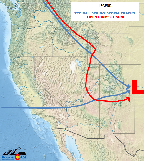
What gets us most excited is that this week’s storm takes a path that should provide the best of both worlds to our state! The anticipated track is shown in red above. The storm will approach from the northwest, briefly pivots in Wyoming, then meanders into the Four Corners before ejecting eastward across northern New Mexico.
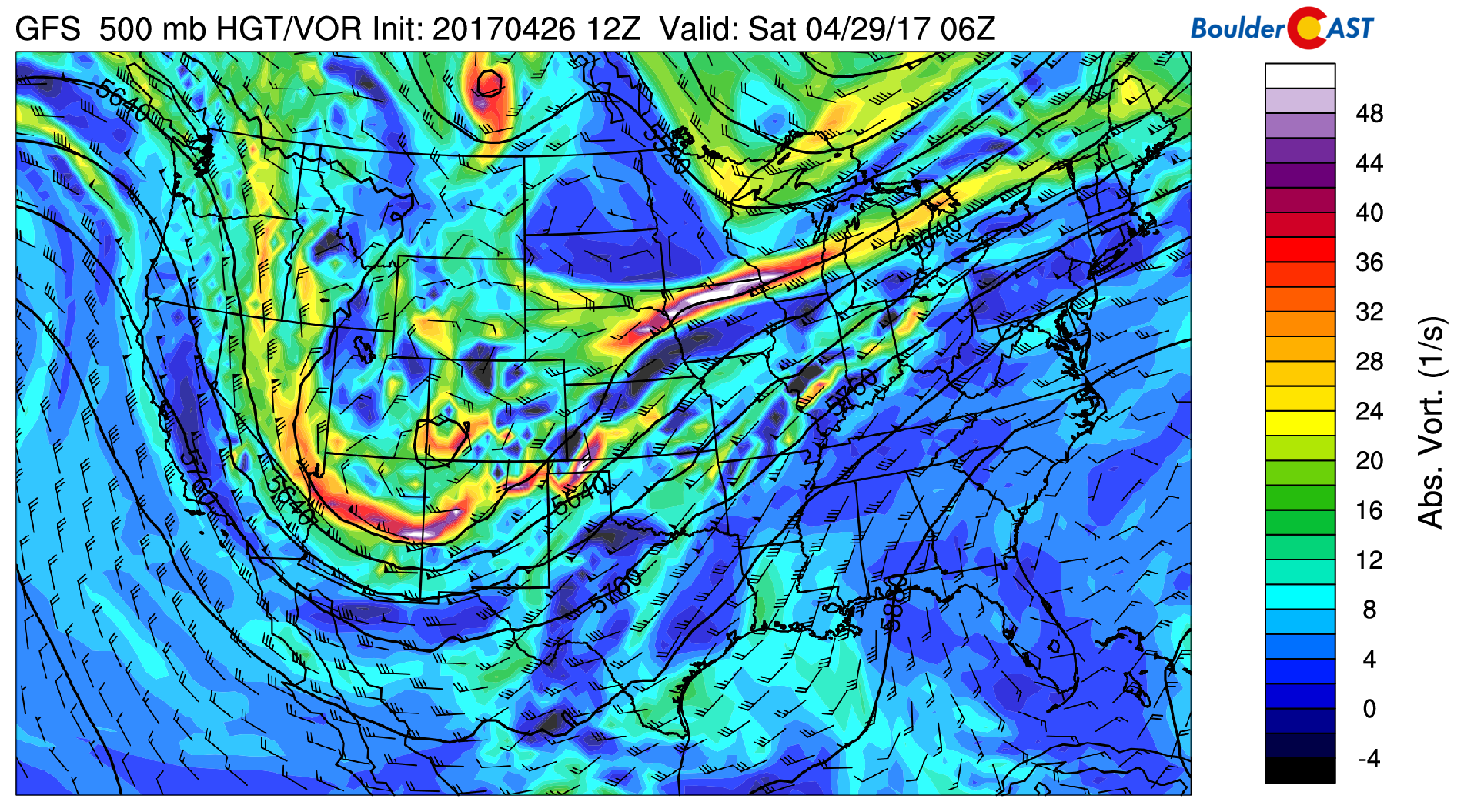
The 500 mb vorticity map from the GFS shows the position of the storm on Saturday morning over southwestern Colorado.
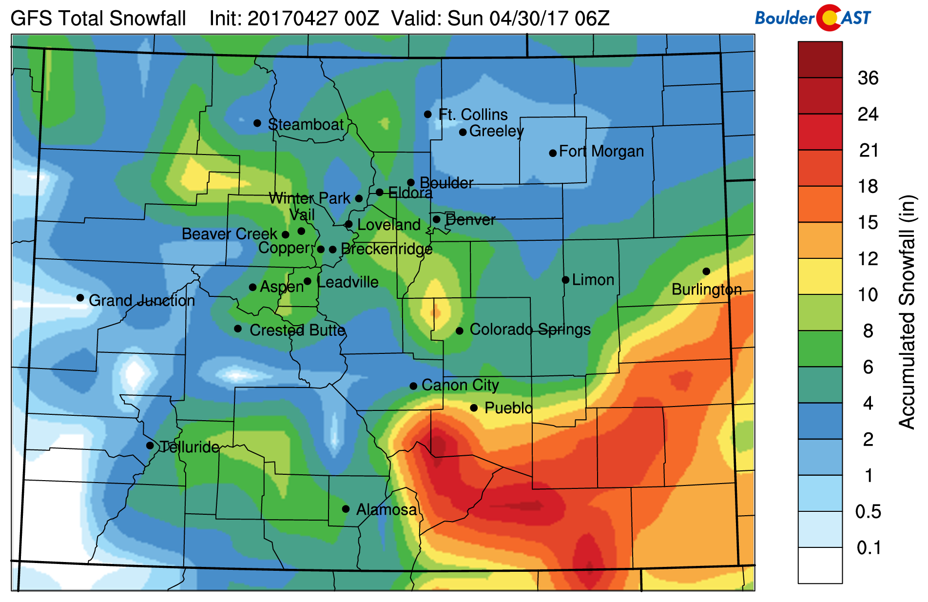
Thankfully, this time around temperatures are the “easy” part of the forecast. Models are predicting plenty of cold air on the northern and western sides of this system. There’s no question that this storm will dump SIGNIFICANT snow in the areas it hits hardest. Right now, though, we’re not optimistic that this will be the Front Range. The big winners for spring snow appear to be central Wyoming where the storm first pivots during the day Friday, then areas right along the Colorado-New Mexico border Saturday morning as the storm ejects eastward and really begins to explode while tapping into Gulf moisture. Both of these areas have fair to high odds of exceeding 12″ of snow. The below map of forecast liquid precipitation from the GFS model depicts these two regions in red circles.
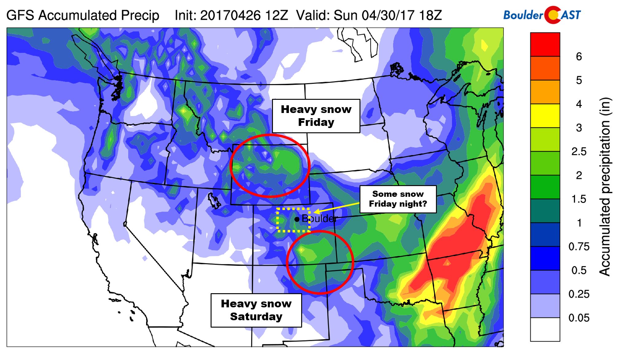
However, this does put the Front Range in a delicate location, smack in the middle-ground between both bulls-eyes. As the storm moves from the northern dumping to the southern one, upslope and snow WILL occur across the Denver Metro and Foothills. It’s just a question of how much upslope and moisture will we see, and how long will it last?
Model variation is still a concern, and this track is VERY tricky one to say the least. The spread in the model ensembles is still uncomfortably large, allowing us only low to medium confidence in our forecast right now. We believe the issue models are having is related to tiny shifts in the storm’s track as it slumbers southward Friday night along the Utah and Colorado border. Slight deviations in any direction will have LARGE impacts for our region.
For now, here are our expectations:
- The first half of Friday will be dry, but precipitation should increase Friday afternoon and especially into the evening as a strong cold front moves in from the northeast.
- Snow levels will start out around 7,000 feet, but will drop all the way down onto the Plains Friday night and remain their through the rest of the storm. Temperatures early Saturday are projected to drop into the upper 20’s in Denver and Boulder. The 700 mb temperature map below from the NAM model for midnight Friday night shows temperatures near -12 Celsius at 10,000 feet over Boulder. This is so cold that snow is essentially guaranteed to be occurring. The GFS and Euro models are even colder. For this reason, we expect a change-over to snow to occur between 8PM and midnight for everyone.
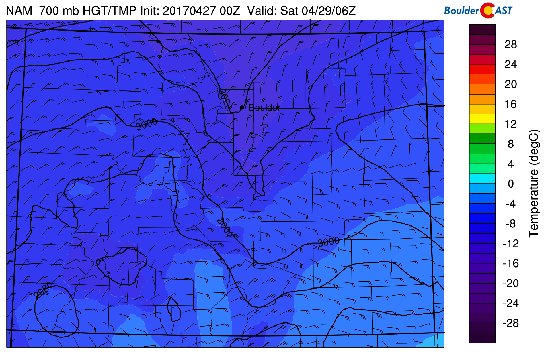
NAM 700 mb temperatures forecast for midnight Friday night showing cold air across the region. Plenty cold enough to support snow.
- Note in the map above that winds at 700 mb are more northerly than easterly around Boulder..not the most favorable upslope direction. Those juicy, due-easterly winds are confined to southern Colorado (where they will remain most of the storm).
- The wind field looks favorable to keep at least light snow lingering across the Denver Metro into Saturday afternoon, especially in the southern and western suburbs.
- We’re thinking this storm should produce 2-5″ of snow in the Denver Metro Area, with 4-10″ in the Foothills and Palmer Divide. Areas north and east of Denver will see lower amounts, likely less than 2″.
This is the latest snowfall forecast for the storm derived from GFS model data. This is not our official forecast, but we actually think it looks reasonable.
There are bound to be a few tweaks to our forecast needed before the system arrives Friday evening. Check back tomorrow for our final forecast update and snowfall map. In the meantime, get your milk, eggs, and bread before everyone else inevitably does!
.
Don’t be selfish…share our forecast with your friends!
.


Great post! I just moved to Boulder yesterday. Looking forward to learning more about the weather on the Front Range. As an avid paraglider pilot, I’m always keeping a keen eye on synpotic weather and its local subtleties. I’d love to chat more about this! aneigher(at)gmail(dot)com
Welcome to Boulder and thanks for reading, Alex! Paragliding is a popular pass time here for sure. We’d love to hear more, such as what type of weather/wind patterns are desirable and troublesome for you. Feel free to contact us directly via email or on social media.