Over the course of the next 24 hours, there will be a drastic change in our weather! Temperatures will fall nearly 60 degrees, with the warm spring breezes of Sunday afternoon being replaced with freezing drizzle, snowflakes, and bitter cold. Let’s take a look at the incoming winter storm set to drop our first significant snowfall of the New Year, including timing and snowfall amounts.
*Premium Storm Update* Mon 2/3/2020 8:00AM: We discuss when the freezing drizzle will change to snow and why we think Monday’s evening commute will be very treacherous. Click HERE to read.
T
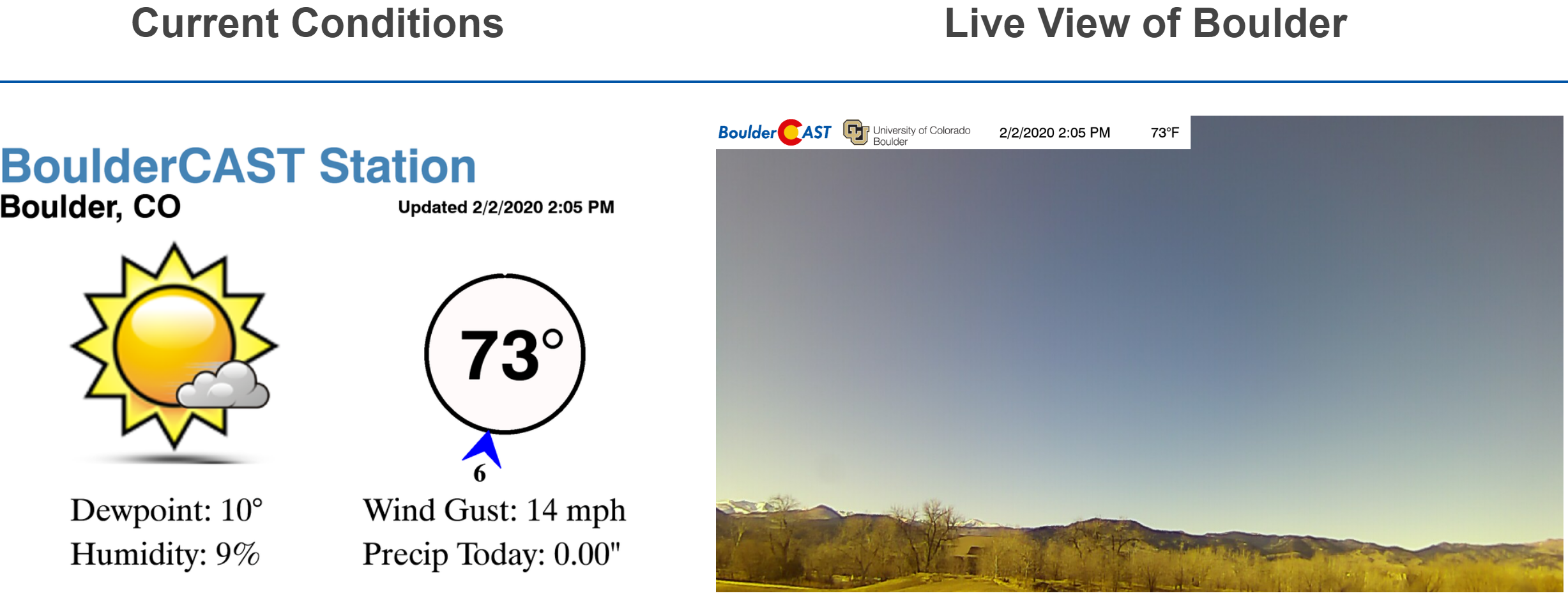
he “warm before the storm” is in full-swing here on Sunday afternoon! Temperatures have cracked the 70-degree mark in most Front Range cities….nearly record warmth for the date. It’s a little bit breezy, but otherwise with full sunshine, there’s not much wiggle room to complain for this time of year!
It has been more than two months since we’ve had a real winter storm system follow a track from west to east across Colorado. That is exactly the path our incoming snow-maker will take dropping southeastward from western Canada into northern Utah by early Monday and then into southern Colorado by Monday night. A rough storm track is outlined in the 500mb height anomaly forecast map below.

GFS 500 mb height anomaly forecast map for Monday morning showing the expected track of the storm
A favorable storm track for the Front Range is one where the low pressure passes just to our south. This is because counter-clockwise flow around the low produces easterly winds north of the storm’s track. As you know, this is upslope for us! This is the precise setup we will have during the day Monday into Tuesday. The GFS 700mb temperature and wind forecast map below highlights the large swath of easterly winds north of the low spreading from Wyoming into northern Colorado Monday evening.
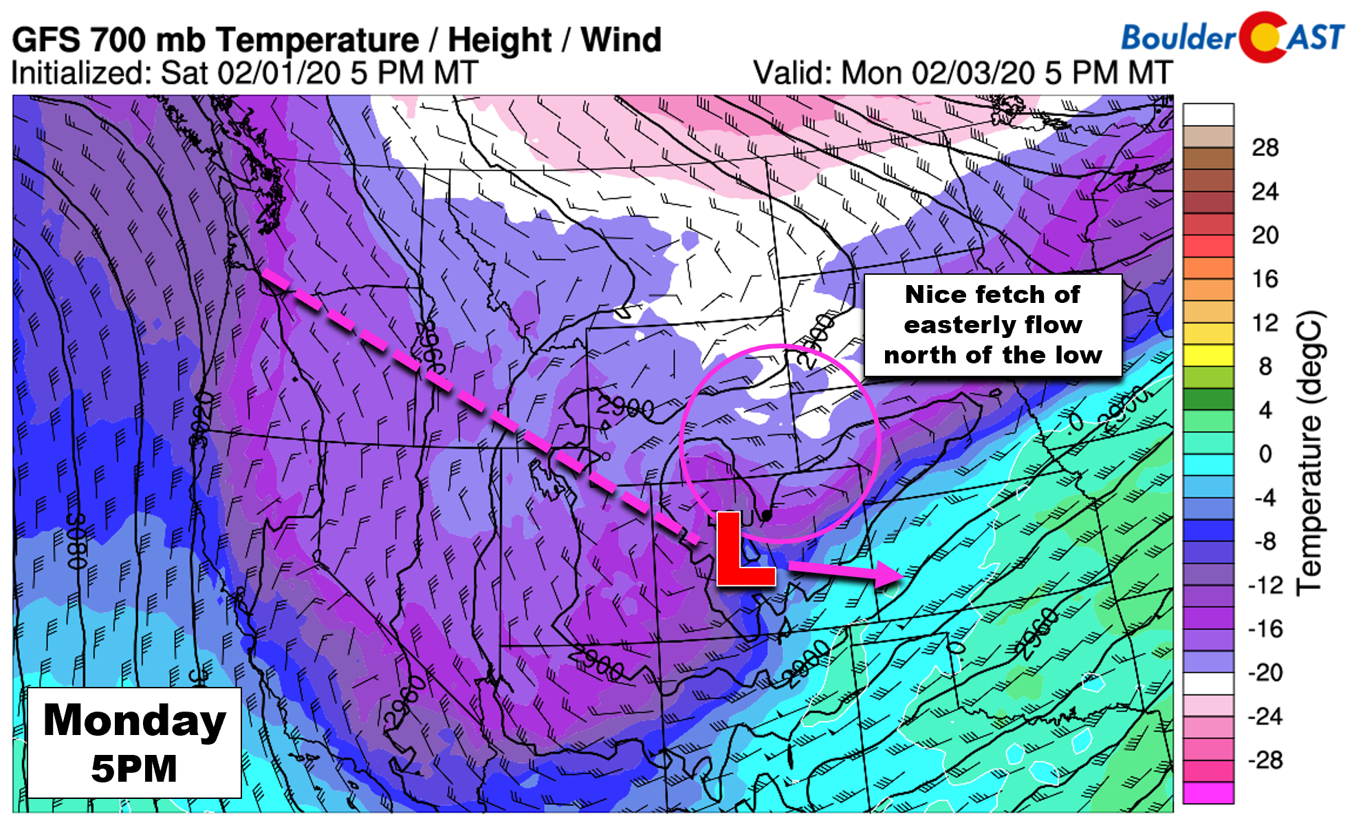
GFS 700 mb temperature and wind forecast for Monday evening. Efficient upslope is indicated across the Front Range as the low tracks to our south
Upslope will persist at the 700mb level (~10,000 feet elevation) from Monday afternoon into Tuesday morning. The graphic below shows the 10 to 20 mph northeasterly upslope winds across the Front Range. It’s great to see the return of upslope to the Boulder area! While not overly intense, this direction is quite favorable for Boulder and Jefferson Counties and should lead to persistent light snow. The most efficient upslope and therefore best chances of moderate snowfall in our area will be Monday afternoon and evening. By mid-day Tuesday (bottom right panel), we begin to see winds turn northwesterly aloft which will start to taper off the snow for many areas.
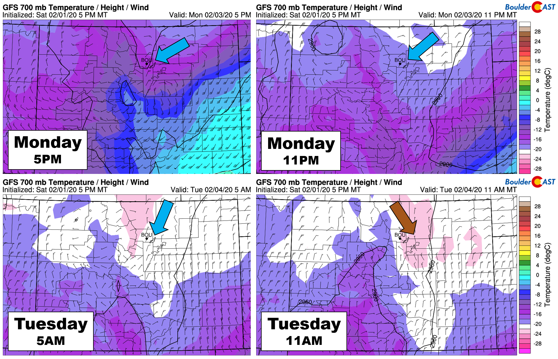
GFS 700mb temperature and wind forecast timeline for the event. Upslope and cold air overtake the Front Range, turning to downslope by Tuesday mid-day
We also must consider that this will be a long duration wintry event. The storm itself is rather slow-moving. From the time the snow begins late Monday morning, some areas could see continual snowfall for more than 24 hours, especially those near the base of the Foothills.
Despite all the bells and whistles this storm is showing off, we do have our concerns. For one, models are now indicating that the upper-low won’t fully close off and will remain a stretched open wave. This just means that the storm’s energy won’t fully consolidate across Colorado and also that stronger deeper upslope is off the table. This is something we expressed concern for in our last forecast update on Friday.
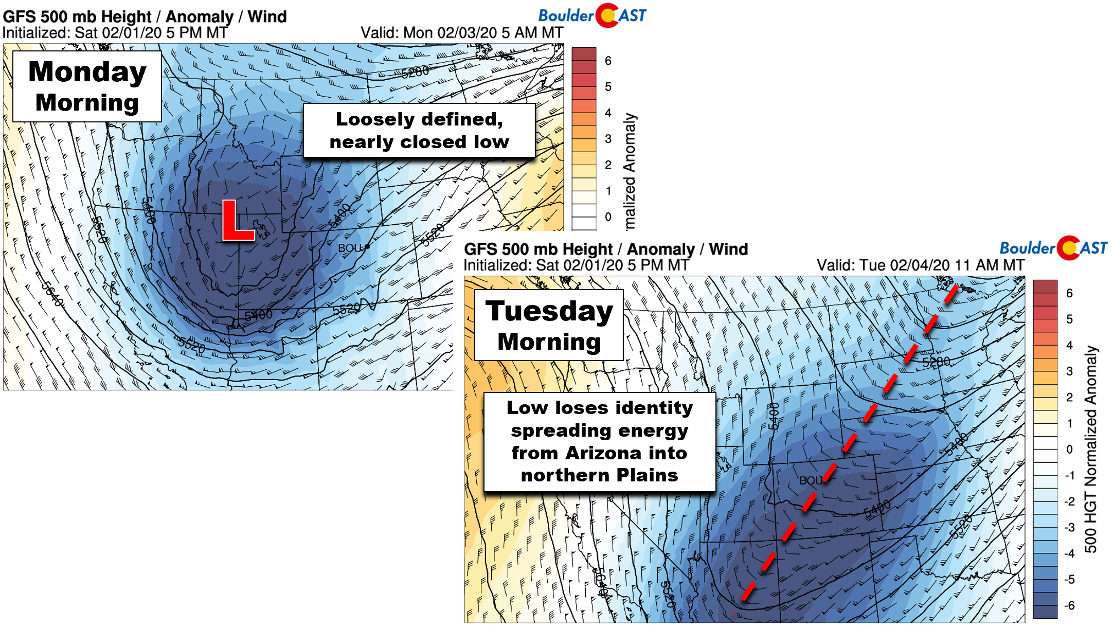
GFS 500mb height anomaly forecast maps for Monday morning (left) and Tuesday morning (right). The storm weakens and looses its identity in time
Another consequence of the slow arrival and movement of the storm is that very cold air will eventually push into the Front Range Monday night and early Tuesday while upslope is still on-going. We expect temperatures to drop well below zero in the Foothills and into the single digits to lower teens across the Plains during this time. The Arctic airmass oozing into the area will be so cold that it won’t be able to support dendritic snow growth. This will tank snow ratios on the back half of the snowstorm as smaller, less fluffy crystals become the dominant type. For dendrites, we need an appreciable layer aloft with temperatures between 0 and 10°F.
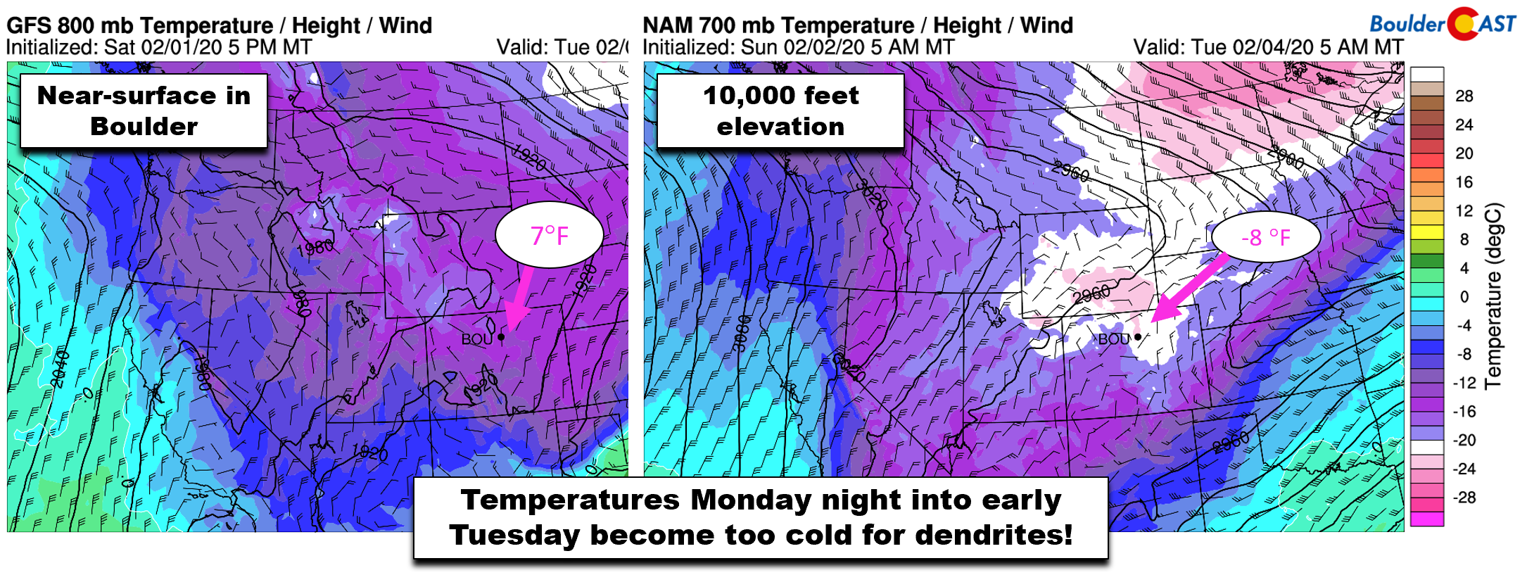
GFS temperature and wind forecast maps for Monday night from near ground-level (left) and near 10,000 feet elevation (right)
Timeline
It may be toasty now, but things change quickly Sunday evening as the cold front arrives! It’s coming in a tad slower than original expectations and is currently looking to push from north to south across the Denver Metro area between 8 and 11PM Sunday evening. Temperatures will quickly fall behind the front dropping into the 30’s overnight and into the 20’s by sunrise Monday. The atmosphere will be in a weird place early on where the cold surface layer saturates but warm and dry air still remains aloft. This will produce a period of freezing drizzle across the Metro area and lowest Foothills Monday morning. It’s always difficult to pin-point freezing drizzle in regards to timing and location, but we do expect most of the area will see some icing Monday morning.
As colder and moister air arrives aloft around mid-day Monday, freezing drizzle will turn over to snow. As mentioned earlier, Monday afternoon and early evening will have the strongest push of upslope and lift from the trough in-place. This timeframe will offer the best chances of moderate snowfall across the area. We could see snowfall rates of 1 to 1.5″ per hour during this time in the heavier bursts of snow. Depending on how and where things shake out, this could wreak havoc on your Monday evening commute.
Upslope weakens through the overnight hours Monday night with even colder air filtering in. Shallow upslope should keep snow going across the region, especially west of Interstate 25, throughout the night. Temperatures will be very cold during this time in the teens to single digits so snow-packed roadways are inevitable Monday evening and into early Tuesday.
Light snow may linger into Tuesday afternoon or evening in furthest western suburbs. Additional accumulations will be light however with bitter cold temperatures. Highs Tuesday will be in the teens.

Uh…brr?
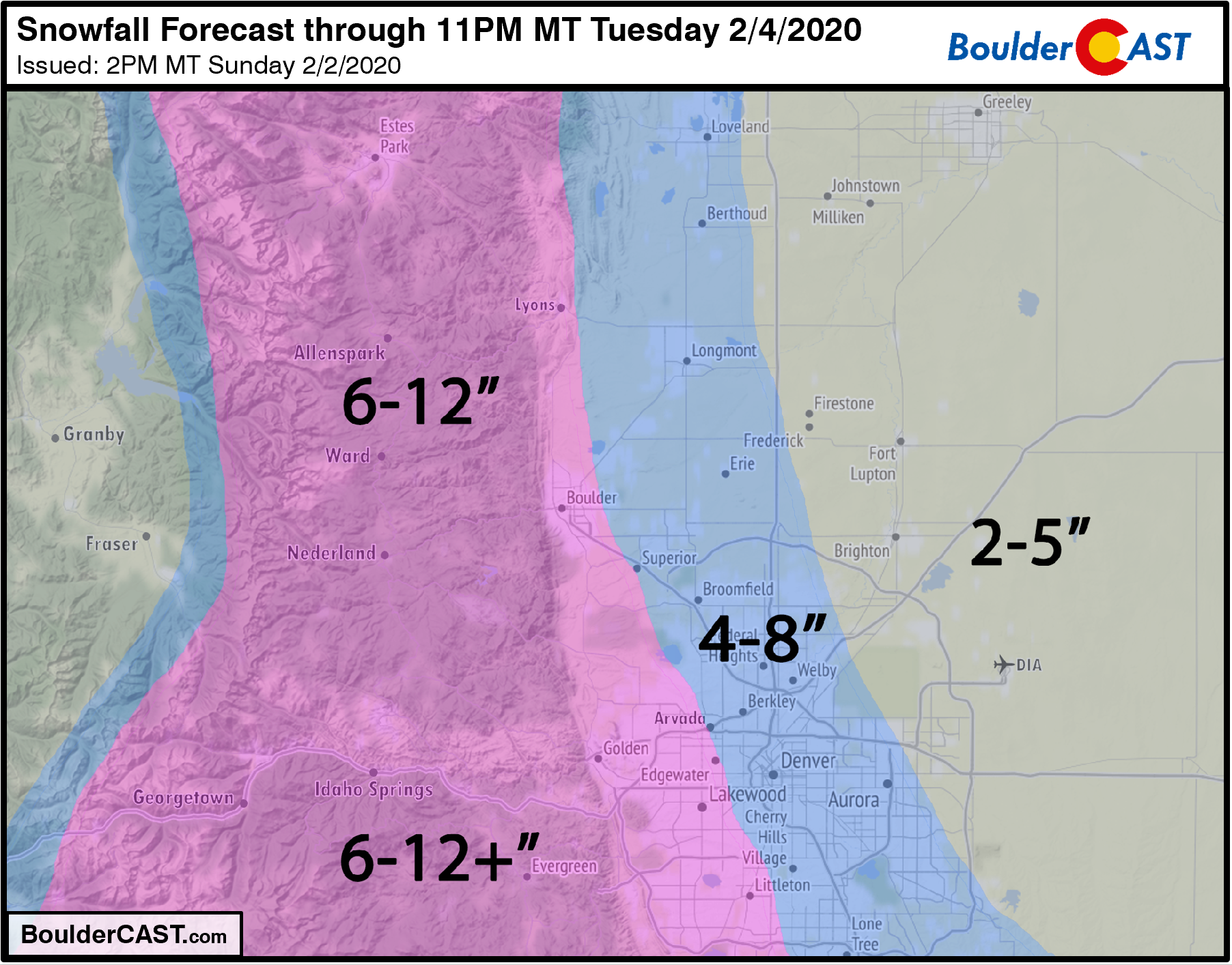
Expected snow totals
Prolonged upslope is the primary forcing mechanism for snow this time around. Thus we are expecting the greatest amount of snow across western portions of the Metro area and in the lower Foothills.
Models are indicating anywhere from 0.5 to nearly 1.0″ of liquid with this storm around Boulder and Golden, down to as little as 0.2 to 0.3″ in eastern Denver near DIA. Given what we discussed earlier about tanking snow ratios, we anticipate an average snow ratio of ~13:1 for this storm with fluffy snow early trending to a sugarlike snow towards the end of the event.
The GFS model has remained the most bullish on snow totals with this storm, predicting more than a foot of snow in Boulder (below on left). However, the NAM (below on right) and European models are in relatively good agreement for slightly lower totals for the Front Range, but nonetheless still sizable.

Given everything we are seeing, are expectations for snow amounts are as follows:
- Boulder area: 6-12″
- Most of Denver: 3-8″
- Further northeast from DIA to Greeley: 2-5″
- Foothills: 6-12″, locally higher amounts in Jefferson County possible
Our official snowfall forecast map for the first major wintry event of 2020 is shown below. This covers snow falling through Tuesday evening.
These spring-like temperatures on Sunday should help keep the impacts from the freezing drizzle early on rather modest. Road surfaces are starting out very warm. BUT…as temperatures cool through the 20’s into the single digits and the heavier snow arrives later Monday, roadways will likely become slick and snow covered. The worst commutes will be Monday evening and Tuesday morning.
We’ll continue to monitor the situation as most of the snow won’t begin until Monday afternoon. If any tweaks to the snowfall forecast are needed, we’ll update this post. Otherwise, we’ll be extending the discussion with additional thoughts and model checks for our Premium members later tonight or early Monday morning.
Get ready for winter’s triumphant return, stay tuned for updates and may your arbitrarily chosen “favorite” team of the Super Bowl prevail!
—
We discuss Boulder and Denver weather every single day on BoulderCAST Premium. Sign up today to get access to our daily forecast discussions every morning, complete six-day skiing and hiking forecasts powered by machine learning, access to all our Front Range specific weather models, additional storm updates and much more!

Subscribe to receive email notifications for BoulderCAST updates:
We respect your privacy. You can unsubscribe at any time.
.
Spread the word, share the BoulderCAST snow forecast!


You must be logged in to post a comment.