The first major storm is coming together quite nicely. We provide some last minute thoughts on the system eyeing the Front Range, and give our final forecast snow totals for the region.
The latest model runs remain mostly unchanged from this morning. They bring the powerful system into Southeast Colorado overnight, and move it into Kansas at a somewhat sluggish pace.
Rain and snow have already moved into the area. Currently, Boulder is running a few degrees warmer than most of the Denver Metro area, and as such, hasn’t changed over to snow quite yet. BoulderCAST Station is hovering at a balmy 38 degrees. We do expect a gradual cool down to continue, but hopefully this warm trend doesn’t last long, which could cut into our snow totals. We expect the change over to occur for everyone before 9pm, with relatively steady snow through 5am.

A majority of the models are pointing to near a foot of snow in Boulder (GFS, SREF, Canadian), but we just aren’t convinced. The warm temperatures, the threat of downslope, the lack of truly dynamic lift over Boulder County, all wave giant red flags of caution. Several models are showing this as well (HRRR, RAP, NAM).
There is high potential for this storm to bust either way (Boulder get more snow, or less). This is to be expected with such a tight gradient in snow totals. As such, our forecast remains largely unchanged for Boulder County from what we predicted this morning. We mostly just ramped up snow totals for the southern and central portions of Denver.
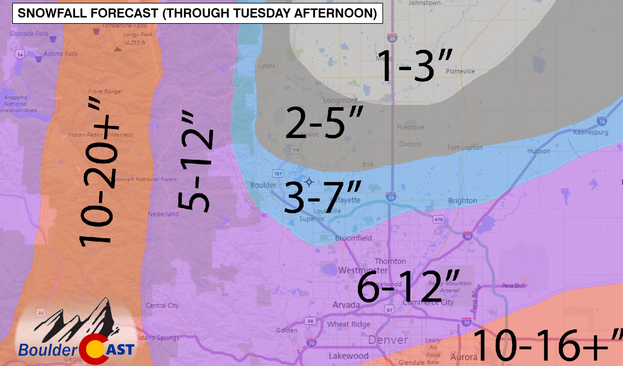
- Plains: 2-7″ (higher totals for the southeast portions of the county)
- Foothills: 5-12″ (southern portions of the county will do better)
- Mountains: 10-24+” (skiers can’t complain about the powder anywhere!)
- Denver southward: 6-16″ (highest totals south and east of the city, particularly in Palmer Divide locals)
With heavy snow and wind on the horizon, travel across parts of the Metro area will be dangerous and in some cases, impossible, tonight through the morning tomorrow. Be safe out there! We all know how dangerous those Priuses can be during the first major snow of the year!
Be sure to subscribe to BoulderCAST to receive notification of all future updates!


