Read our final forecast update discussing the timing, amounts, and impacts for the approaching snowstorm and frigid temperatures.
What a whirlwind of weather changes over the last day or two. This storm was always a possibility, but we doubted it would come to fruition given the fickle nature of the models over the last week regarding this Arctic system. Needless to say, it’s gonna snow!
Everything from our preliminary forecast yesterday is on track. The models have remained remarkably steadfast over the last 36 to 48 hours with this system. Upslope, moisture, and jet dynamics will combine this evening and overnight to produce our biggest snowfall of the winter season!
Timing:
Light to moderate snow is already falling in the Foothills of western Boulder County and in a few areas near the Foothills. This will continue through the day and intensify as moisture arrives from the west. On the Plains, it will be a chilly day with highs in the teens before a front shows up later this morning. Behind the front, moderate snow should commence. High-resolution models shows a start time of 1 to 3PM in Boulder, and 2 to 5PM in Denver. Snow will continue, heavy at times under jet-forced bands, into Thursday morning. Snow will begin to taper off from north to south through the late morning and early afternoon Thursday. Temperature will fall through the single digits tonight and down to near zero or slightly below zero by sunrise Thursday.
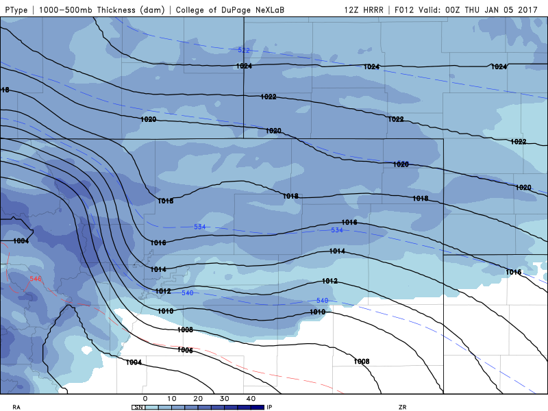
High-res HRRR showing snow encompassing the Metro Area for rush hour Wednesday evening
Amounts:
We’re basically looking at 18 to 24 hours of continuous snowfall in the Denver Area (even longer in the higher elevations and at the base of the Foothills). Upslope will be present throughout (though not as deep as we would like).
Model guidance is in fairly good agreement for Denver to see 0.3 to 0.6″ of liquid, 0.5 to 0.9″ in Boulder, and 0.7 to 1.3″ in the Foothills. Snow to liquid ratios are expected to be ~17:1 for this storm (see below).
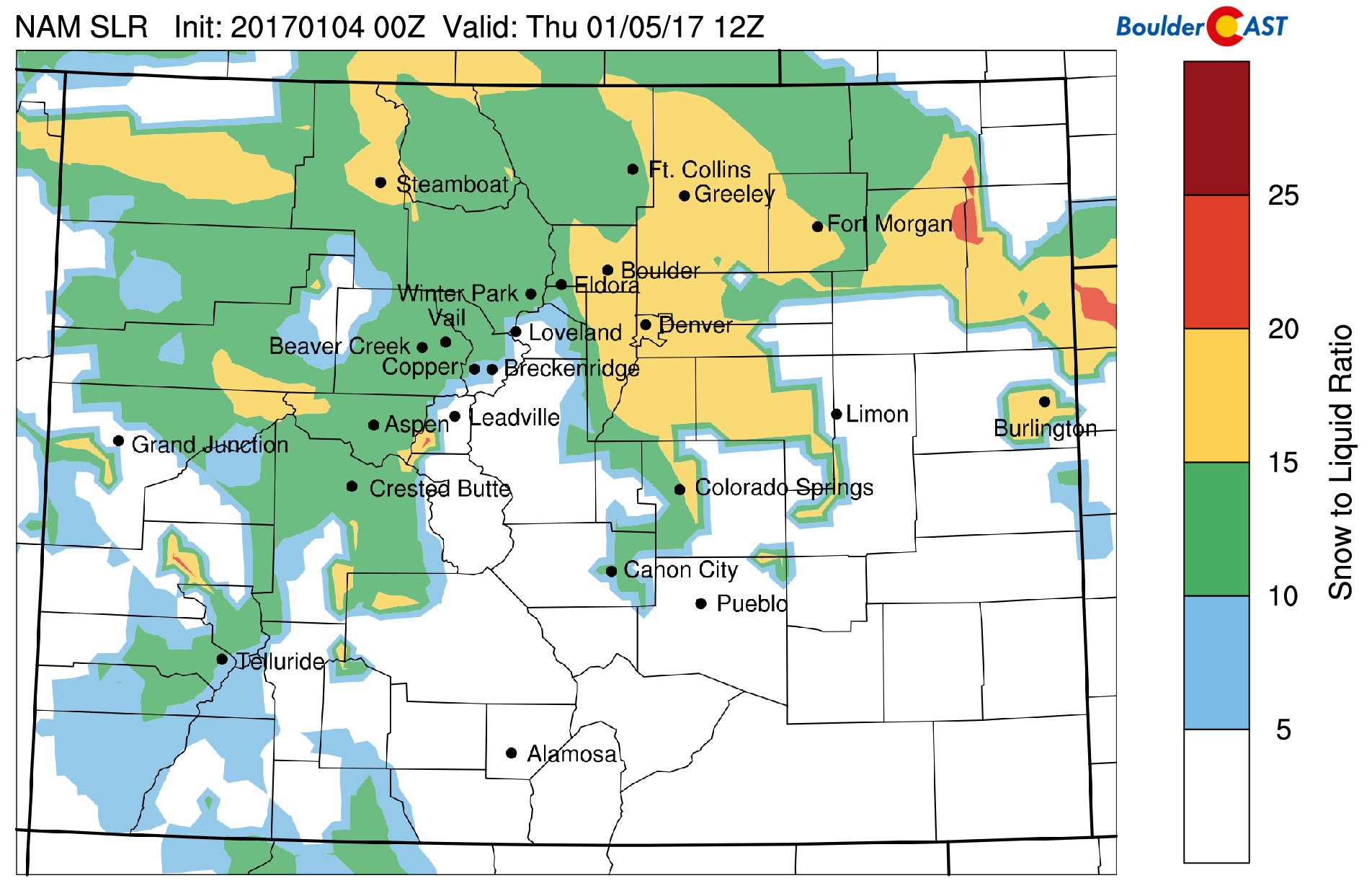
Forecast snow to liquid ratios for Wednesday night, derived from NAM model data
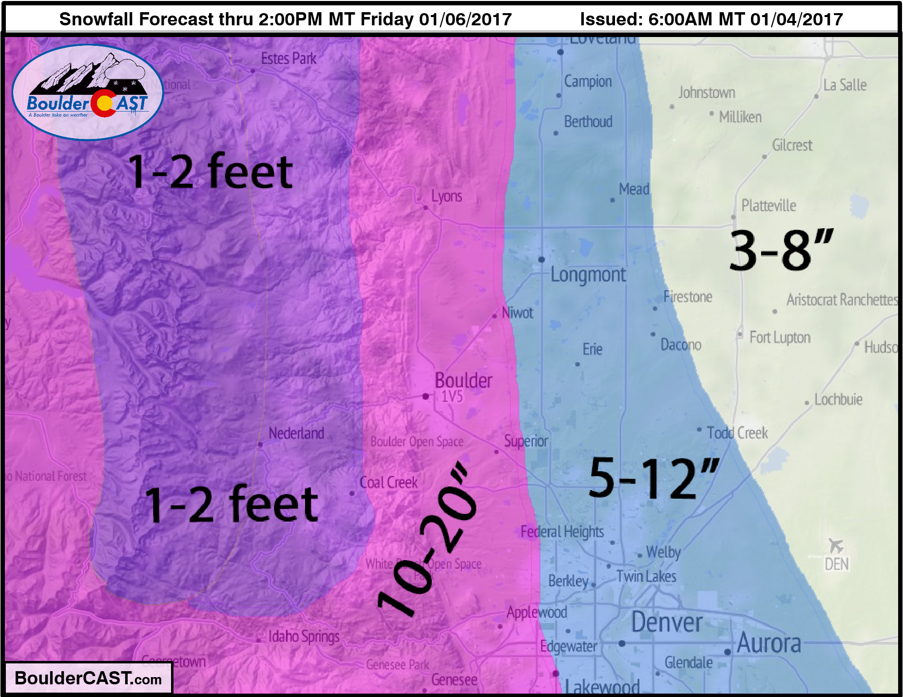
Given everything we are seeing, our snowfall forecast map is below:
Cautions:
The forecast for this storm hinges strongly on the presence of widespread heavy snow bands during the overnight hours tonight. They’re always a difficult forecast, but there are plenty of signs in the models that they should be prevalent this time around. With that, it’s conceivable that localized areas could exceed our forecast, or come up short. We do expect relatively large location-to-location variation, especially east of Interstate 25.
—
We’ll post an update to this post if anything drastic changes. Feel free to update us on conditions or totals from your location in the comments below. Enjoy the snow and stay safe!
.


