As we have been relaying to you all week, another spring snow storm is on the way this evening and will linger into Saturday afternoon. Read on as we detail our final thoughts on the storm and snow amounts for the Foothills and Plains.
STORM UPDATE (Saturday April 29 at 8AM):
Snow totals in Boulder are sitting in the 4 to 6″ range right now, with 6-12″ in the Foothills. The worst of the snow is now behind us. We expect light snow showers to continue in Boulder and the nearby Foothills for much of the day. Additional accumulations will be minimal, maybe an inch or two. It’s almost May, so even with the cloud cover, the sun will be melting things quickly as we approach lunchtime. The roads will be fine and if your power didn’t go out already, you’re in the clear. DIA only received about 2″ of snow, so arrivals and departures should be business as usual.
Our attention turns to potentially record cold tonight. It only got down to around 27 to 29 degrees this morning on the Plains with snow falling. However, we’re expecting some clearing tonight which will allow temperatures to plummet even further. 21 to 24 degrees looks good for the Plains, with teens in the Foothills. This type of cold on the last day of April will be enough to kill certain types of vegetation that is already in full bloom.
Hang in there…we’ll return to the 70’s in no time. More on this in our weekly outlook Monday! Enjoy the rest of the weekend.
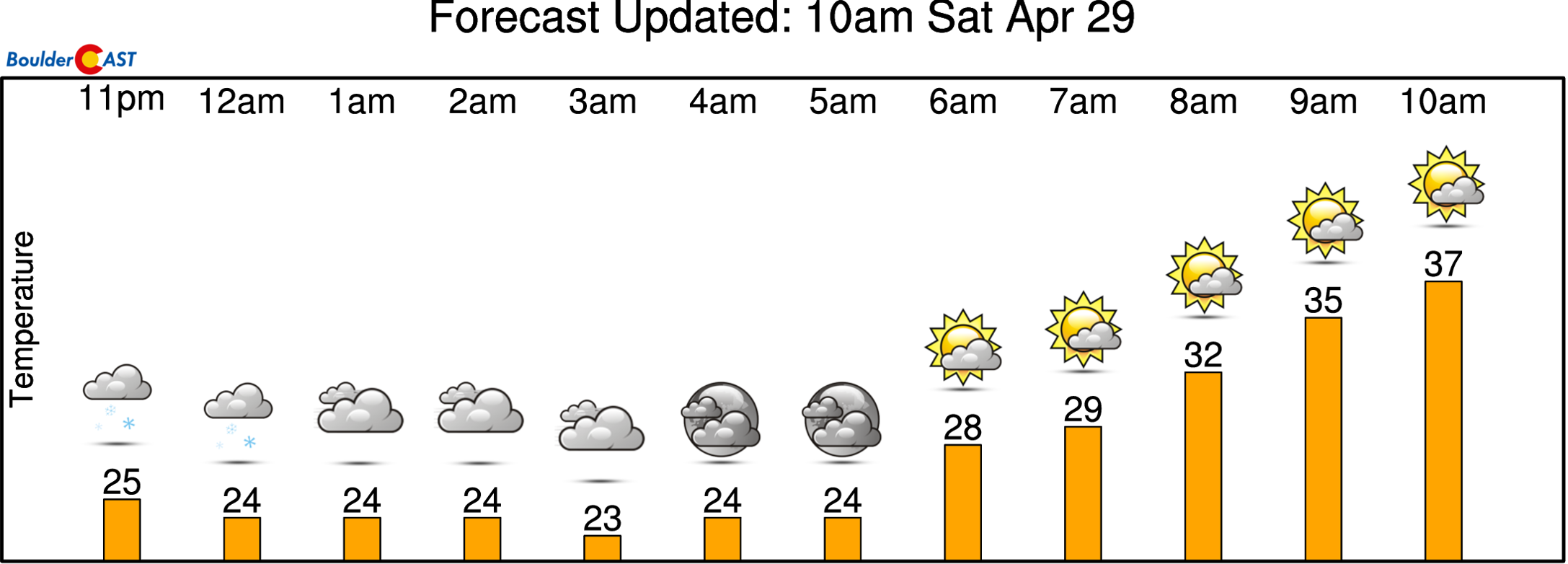
Image from our NowCAST page
Let it snow!
A few of the finer details have been ironed out since our forecast update yesterday, but there shouldn’t be TOO many surprises here…
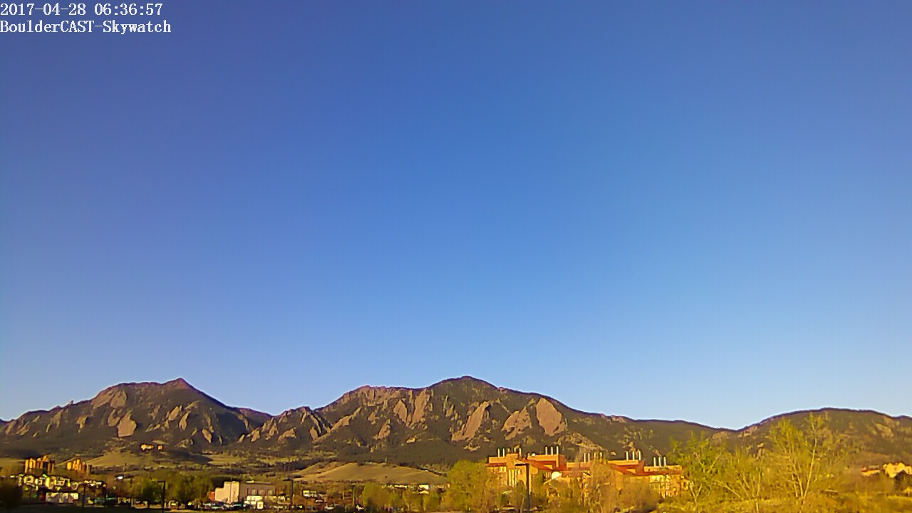
Those deep blue skies this morning hardly hint that it will be snowing in just twelve hours’ time. Conditions will rapidly go downhill this afternoon and flakes will be flying before the sun goes down tonight. Alas, it’s springtime in Colorado!
A strong cold front is set to move through the region later today, with upslope flow on the back end. As noted in our update yesterday, this front will lead to dropping temperatures through the afternoon, approaching freezing by sunset and eventually into the upper 20’s overnight. This cold air is evident in the forecasted snow levels from the NAM for 6PM tonight (below on right). Initially, snow levels start at around 6,500 feet midday, but fall to below 5,000 feet this evening and overnight.
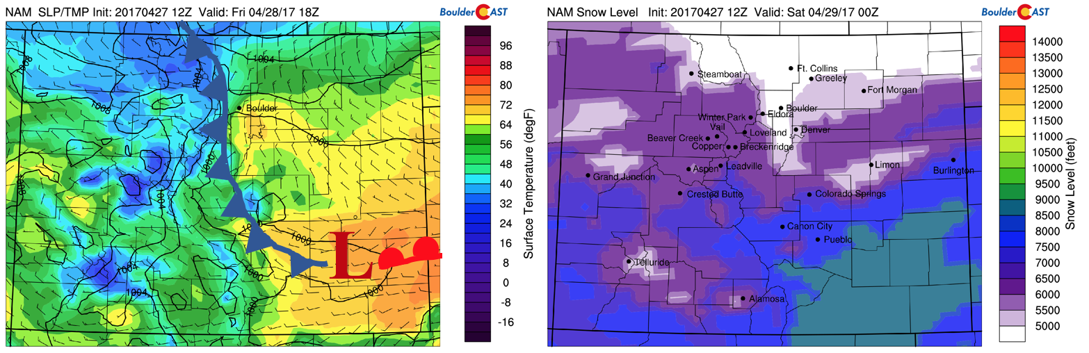
NAM model surface temperature and frontal boundaries this afternoon (left) and NAM snow level prediction for this evening (right)
The biggest change in our forecast from yesterday is that the colder air will be arriving slightly ahead of schedule. Rapid cooling aloft behind the front will lead to the potential for convective precipitation this afternoon and evening. With the colder temperatures through the bottom third of the atmosphere, this heavier precipitation could be more snow than it is rain. This could be a game-changer for some areas. The HRRR model forecast precipitation loop ending at 11PM tonight shows this potential for heavier bands with snowfall rates of 1 to 2 inches per hour. This is especially true in and near the Foothills where convection should be focused.
HRRR animated loop of precipitation and type through midnight tonight. A quick change-over to snow is apparent around 6PM to 8PM
With the latest guidance, we expect only a quick shot of rain this afternoon on the Plains, maybe just a couple of hours, before things fully change-over to snow for everyone between 5 and 9 PM. This earlier change-over will boost totals slightly from our predictions yesterday.
Uncertainty, even less than 12 hours out, is still present with this storm system. The exact track and subsequent re-intensification of the low pressure to our south is a tough forecast. Thus, we are not overly confident in exactly what may happen…
GFS 500 mb vorticity animation from the GFS through Saturday
One of the reasons for the uncertainty in the forecast lies in the strength of the low pressure system itself. Below shows the GFS model upper-level jet stream pattern for midnight tonight. It depicts a strong jet across the Pacific Northwest, and another jet streak stretching from New Mexico, northeast into the Great Lakes. The GFS model is somewhat weaker in regards to the low pressure system coming out of northern Arizona. The Euro, NAM, and Canadian models, however, are slightly stronger. This small difference leads to a position shift in the entrance region of the jet streak over southeastern Colorado. The Euro/NAM models place this further north, while the GFS (see below) places it over the southeastern part of the state. If the stronger, more northern track verifies (which we think it will), snow totals will be boosted.
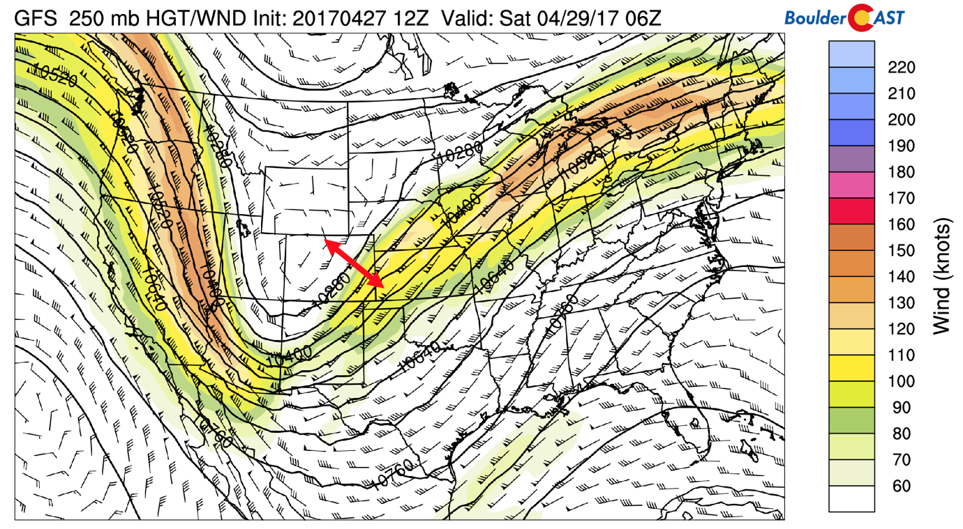
GFS upper-level jet pattern midnight tonight. Red arrow denotes the range of forecasts of the jet streak across Colorado among the models
As a result of that weaker, southern track, the GFS is producing just 0.2 to 0.6″ of liquid across the Front Range. The NAM and Euro are wetter (snowier!) with liquid projections ranging from 0.5″ to over 1″ south and west of Denver. We’re going to blend our forecast towards the European and NAM solutions. The GFS looks too far south and a little “off” with the wind fields across northeast Colorado. What this means is MORE snow than we were thinking yesterday (and even more than other weather outlets are predicting right now).
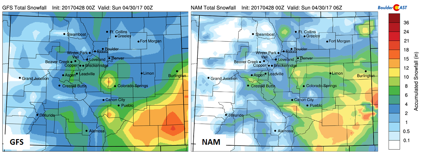
Snowfall forecast from the GFS (left) and NAM (right) models.
Throughout the week, model forecasts have been rather consistent on the track and evolution of the system. The remaining uncertainty lies in the tiny details, which almost always make or break a Front Range forecast.
Timing & Amounts:
- With the cold front plowing through this afternoon, cloud cover will be increasing and light rain showers will develop. These will quickly change over to all snow by early evening with temperatures falling to the freezing mark around sunset.
- The timing of the event will be from 3PM this afternoon until early afternoon tomorrow, with the strongest period of snowfall between 8PM tonight and 4AM tomorrow morning.
- Convective showers could lead to embedded heavy snow in and near the Foothills late this afternoon and evening. Overnight, jet-forced banded snow is also possible, but shouldn’t be widespread.
- Snow will initially only stick on grassy surfaces in the evening, but eventually it will stick to roads and sidewalks overnight with temperatures dropping into the upper 20’s. Be careful if out and about, especially in the Foothills and Mountains.
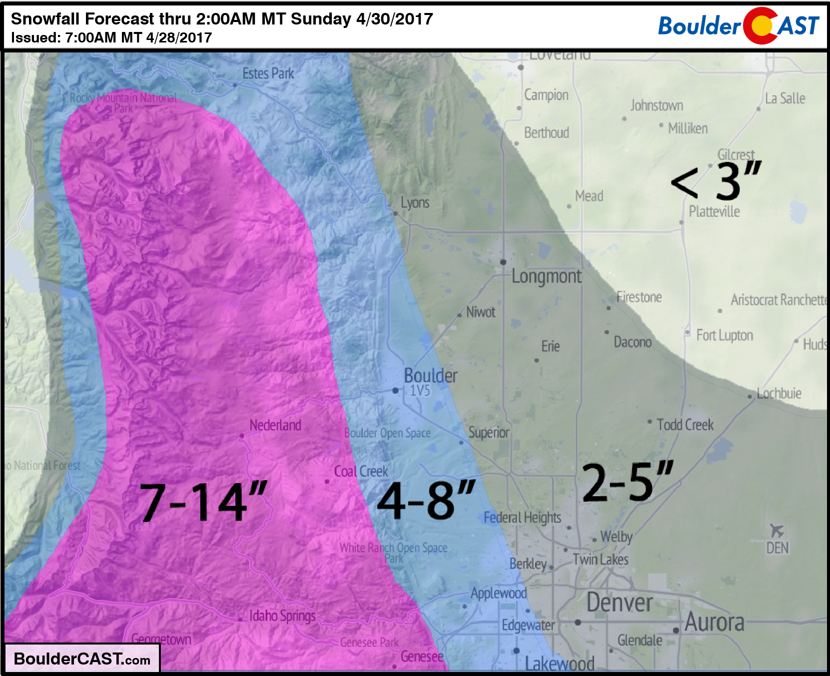
- We are still predicting about 3-8″ of heavy wet snow across the Plains, with 7-14″ in the Foothills. Generally totals will be higher south and lower north. For the finer details, see our snowfall forecast map below. This snow will be the heavy variety, so power outages and broken tree limbs will be possible in areas that creep towards or past the 6″ mark.
- Stay warm as highs Saturday will only reach the upper 30’s and overnight lows by Sunday morning will drop to the LOWER 20’s. Yikes! Be sure to bring your potted plants indoors.
Don’t be selfish…share our forecast with your friends!


