
Around a foot and a half of fluffy snow fell in Boulder for Easter, while many areas saw much less. We take a look at snow totals from around the region. We also discuss our next wave of snow coming Monday afternoon into the evening, as well as the outlook for the rest of the week (spoiler: there will be more snow). Let’s get to it!
We discuss Boulder and Denver weather every single day on BoulderCAST Premium. Sign up today to get access to our daily forecast discussions every morning, complete six-day skiing and hiking forecasts powered by machine learning, access to all our Front Range specific weather models, additional storm updates and much more!

Key Highlights from This Post:
- Easter snow totals were BOOMING in some areas, including Boulder which saw nearly 18″ so far
- A resurgence of snow expected through the day Monday with up to 6″ of additional accumulation expected
- Cooler than normal temperatures persist the rest of the week
- Another good chance of accumulating snow Wednesday night through Thursday
- The upcoming weekend looks much nicer

EASTER SNOW TOTALS
Winter arrived in a hurry around midnight Saturday night as a gusty Arctic cold front blew through from the north right on schedule. Temperatures dropped from the mild 60’s into the lower 20’s rather rapidly with snow quick to follow. Pockets of heavy snowfall impacted the northern Front Range before sunrise on Easter with very fluffy snow ratios. Places from Boulder to Loveland to Greeley reported nearly 6″ of snow from these bands alone. This was much more than expected from the initial wave and ultimately this led to BOOMING snow totals in these areas for Easter Sunday!
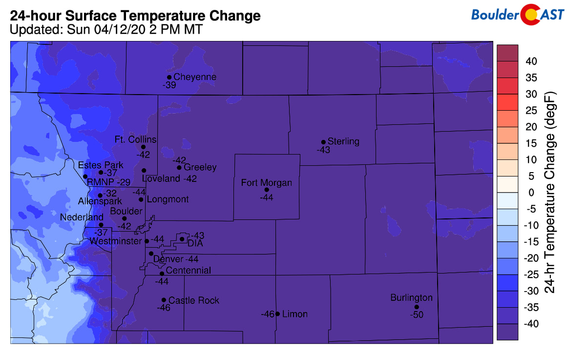
Impressive 24-hour temperatures drops of 40-50°F from Saturday 2PM to Sunday 2PM
The rest of the snowstorm played out just as expected with persistent light snow across the Front Range focused west of Interstate 25. This snow continued in the Foothills and adjacent Plains nearly continuously during the day Sunday and into Sunday night, whereas areas further east saw breaks in the action and even a few peaks of welcomed sunshine! By 6:00PM Sunday evening, Boulder had broken its daily snowfall record for April 12, recording 8.8″ of snow. By contrast, Denver International Airport barely saw measurable snow on Easter Sunday; just 0.1″ was reported at Denver’s official climate station.
As the sun went down Sunday evening, we expected this to be the best period for widespread accumulation under the cover of darkness and this was the case in many areas. Light snow continued with very generous snow ratios, especially in and near the Foothills. Boulder, Golden, Arvada, and Littleton all picked up another 4-8″ overnight, while 1-3″ fell elsewhere. The snow table at CU Boulder is showing just over a foot of snow as of Monday morning. This is even after 24+ hours of compaction and minor melting Sunday afternoon (so we know actual totals were a little bit higher). Update: The official storm total through 7:00 AM Monday was an incredible 15.4″ in Boulder!
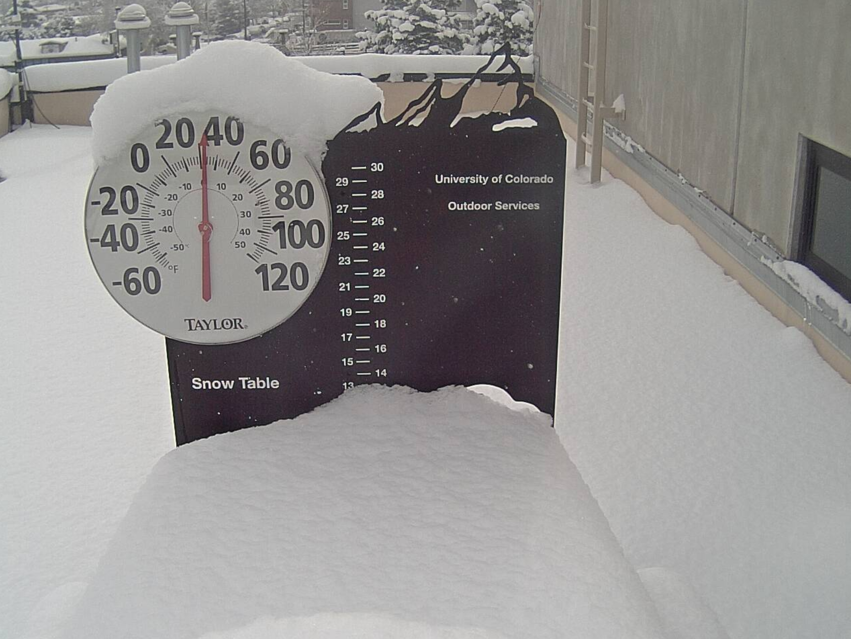
CU Boulder snow table as of 7AM Monday. About 13″ deep, after lots of compaction and some melting.
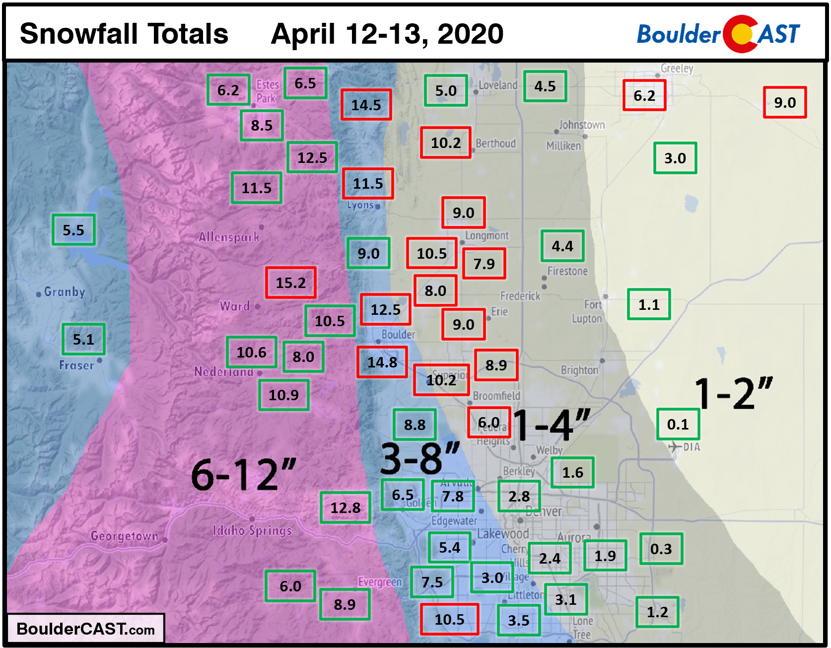
Shown below is our snowfall forecast map for the Front Range issued Saturday afternoon with actual storm totals overlaid in boxes. Green boxes indicate that our forecast verified to within one inch of the observed snowfall. Red did not. Overall, forecast verification wasn’t great for portions of the northwest Metro area. The extra snow above our forecast came primarily before sunrise Sunday, while the rest of the storm played out as expected.
OFFICIAL TOTALS
Boulder: 15.4″ (3– 8″ forecast)
Denver: 0.1″ (1 – 2″ forecast)
Largest Report: 15.2″ near Ward in Boulder County
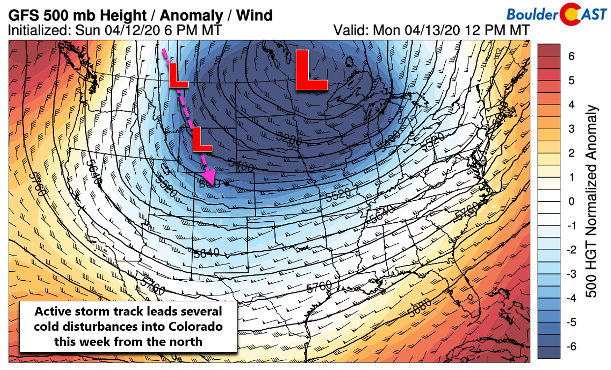
COLD AND SNOW LINGER
Snow re-intensifies quickly Monday afternoon and evening
nfortunately, the cold and snow aren’t leaving anytime soon. This lingering cold air mass was something we discussed nearly a week ago. The deep trough across the center of the country will remain relatively stationary for the next few days with the very cold airmass beneath it, strong high pressure and associated upslope holding firm across eastern Colorado. This setup will allow for frequent and cold disturbances to drop south out of Canada into Colorado during the week ahead. The first will push through our area Monday afternoon and evening. A second will arrive late Wednesday through Thursday. Both will offer additional lift for snow and more gentler pushes of cold air than what we saw on Sunday.
While continued upslope through the day Monday will keep light snow from fully ceasing in many areas, it will certainly pick up again in both coverage and intensity as our next piece of shortwave energy moves through this afternoon and evening providing additional lift.

NAM 500mb vorticity animation show another shortwave traversing Colorado Monday afternoon and evening
Similar to the round of snow yesterday and last night, this secondary wave will be focused across western and southern portions of the Metro area due to the low-level upslope. However, just about everyone should see additional light accumulations. In general, we’re only expecting about 0.1 to 0.3″ of moisture from this system, possibly a little more right along the base of the Foothills and in Boulder where those northeasterly winds will be lifted most. Despite good snow ratios due to the cold temperatures, the April sun will be helping to melt much of what falls through the day Monday. However, the prolonged period of light snow, especially as we get towards the evening on Monday will allow for up to a few inches of additional accumulation. Snow will be most intense and widespread from mid-afternoon into the evening, tapering off from north to south after midnight.

Our snowfall forecast map for additional snow falling during the day Monday through Monday night is shown below. In general, look for another 2-5″ in western and southern suburbs and Foothills, with up to 2″ elsewhere.

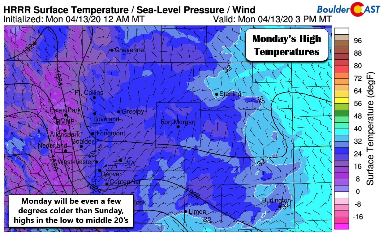
The bitter cold continues to be a story today with numerous record lows set this morning (middle teens) and possible record low highs expected this afternoon. Most areas across the lower elevations will reach only the middle 20’s. This is nearly 40°F below average for this time of year!
After the snow on Monday, there will be a slight warming trend through Wednesday before the next wintry disturbance tracks into Colorado. We haven’t taken much of a look at this system later in the week, but it certainty will offer another excellent chance at accumulating snow alongside a reinforcing pulse of cold air. It doesn’t appear to pack quite as cold of a punch, but we do expect temperatures dropping back into the 30’s for highs on Thursday. If you want to focus on the light at the end of the tunnel: mild northwest flow returns by Friday and into the upcoming weekend. This will allow for warmer temperatures heading into the weekend (close to normal!) and sunnier skies.
Stay tuned for updates as the cold and snowy weather will be with us through Thursday night! Subscribe to BoulderCAST to get instant email notifications when our new forecasts go live, and don’t forget to follow us on Facebook or Twitter.
We discuss Boulder and Denver weather every single day on BoulderCAST Premium. Sign up today to get access to our daily forecast discussions every morning, complete six-day skiing and hiking forecasts powered by machine learning, access to all our Front Range specific weather models, additional storm updates and much more!
.
Spread the word, share the BoulderCAST snow forecast!


You must be logged in to post a comment.