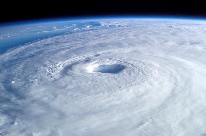
As we approach the heavily anticipated second half of hurricane season, some of you here in Boulder may be wondering, “Is this a good year to vacation somewhere in the Caribbean or Northern Atlantic Basin?” Ten years ago, many hurricane experts would warn you of impending danger that could form pretty much anywhere in the tropical Atlantic. However, we are seeing a change in the long-range weather patterns that have the Caribbean islands leaping for joy! After decades of seemingly constant activity, it appears the tables have turned for the better. While the potential for a strong hurricane can always occur when the conditions are right, it is about time residents along the U.S. Gulf and Atlantic coasts can breathe a little easier. Or can they?
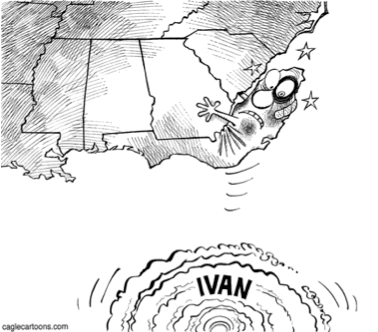 For anyone planning a vacation on water-exposed venues, always prepare for the worst and hope for the best. If you are planning a Caribbean cruise, do your homework. Research the weather forecast on a daily basis for islands nearby. Look at the tropical computer models to investigate what they think. If you can, be religious with your research! After all, these vacations tend to be expensive (as you probably already know). Even on years where the overall season was inactive, we have witnessed “the big one” occur. In 1992, we only witnessed six named tropical cyclones in the tropical Atlantic, but one of them happened to be a powerful land-falling hurricane named Andrew, containing maximum sustained winds of 165 mph as it made landfall. It first moved over southern Florida in late August and made a second landfall over south-central Louisiana as a weaker version of its former self. It currently stands as one of the costliest hurricanes in history. In 1997, we only saw seven named storms, but one was named Danny. This weak category 1 hurricane made landfall over the central Gulf Coast on July 19, dumping feet of rain (yes, feet!) over coastal regions of Mississippi, Alabama, and the Florida Panhandle. Some areas received nearly four feet of rain before Danny slowly drifted into inland cities. So inactive does not necessarily mean completely safe from danger. However, the odds do land more in your favor.
Why is 2015 expected to be so quiet? There are multiple factors we believe are playing a role here:
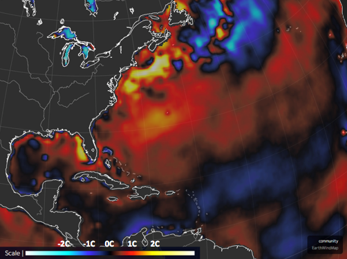
- Sea surface temperatures (SST’s) have been 2 – 3 deg C (3.6 – 5.4 deg F) cooler than average thus far over much of the tropical Atlantic, including parts of the Gulf of Mexico and Caribbean Sea. Instead of the entire Gulf of Mexico exceeding 90 deg F for much of the previous 20 years, temperatures are struggling to hit 86 F at present. Usually, water temperatures as low as the upper 70’s support tropical activity. However, the strongest hurricanes had the luxury of anomalously warm SST’s. See the map below of the observed SST anomalies over the tropical Atlantic as of July 8. Notice the swath of cooler waters across the Atlantic, through the Caribbean, and into the western Gulf.
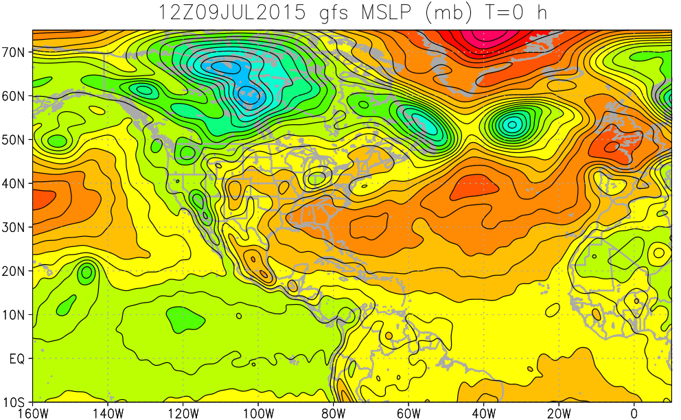
- The Bermuda High that resides over much of the northern Atlantic Ocean has kept the atmosphere stable, limiting tropical activity up to this point. This feature is one of the main steering mechanisms for many tropical cyclones. Anomalously cool SST’s and stable conditions should keep the number of named tropical cyclones low as long as these conditions remain in place. The map below shows the surface atmospheric pressure at 12Z (6am MDT) on July 9, the main feature for locating tropical development,
 and also the 500mb height and vorticity levels at 18Z (noon MDT) on July 9 (shown below), which tell us the weather pattern at roughly 18,000-20,000 feet above sea level.
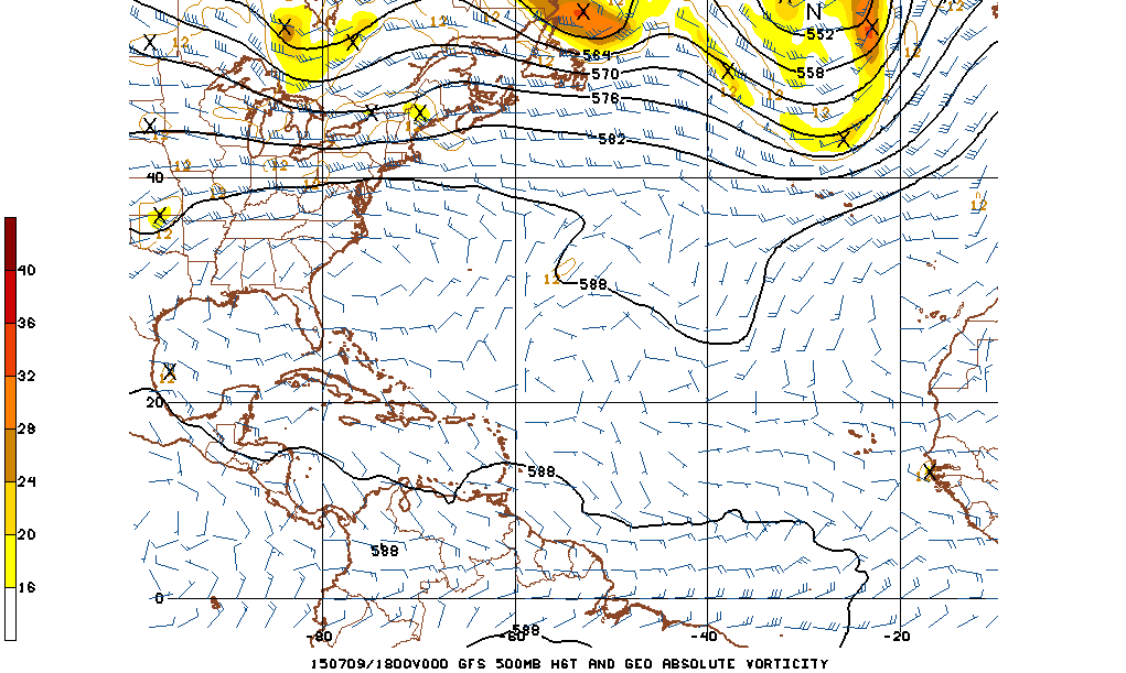
Vorticity is the amount of spin that exists in the atmosphere. If the vorticity is positive, then there exists a counter-clockwise spin in the northern hemisphere; if vorticity is negative, then there exists clockwise spin in the northern hemisphere. These two figures indicate docile conditions across the entire Atlantic Basin. - Two SST oscillating patterns in the Pacific influence the kind of wind patterns the tropical Atlantic observes. The El Niño Southern Oscillation (ENSO) occurs in the equatorial Pacific containing two phases: El Niño and La Niña. El Niño is the positive phase that generally contributes to low tropical cyclone counts in the Atlantic. During El Niño, SST’s in the equatorial Pacific are anomalously warm and increase the upper level winds felt over the tropical Atlantic. La Niña is just the opposite of El Niño, where SST’s are unusually cool in the equatorial Pacific. This phase usually weakens the upper level winds that the tropical Atlantic sees, thus leading to more favorable conditions for tropical cyclone development. The flip-flop between these two phases occurs generally every 2-10 years. The Pacific Decadal Oscillation (PDO) is like ENSO, except that it is defined as a change in SST’s over the Pacific Ocean in the northern hemisphere. The change from a warm phase to a cold phase is known to occur over decadal time scales, usually every 20-30 years. During the warm phase, the western Pacific becomes anomalously cooler while the eastern Pacific is anomalously warmer. During the cold phase, the roles are switched. It is believed that the PDO affects ENSO, which would ultimately affect the potential for tropical cyclone development. Currently, both the ENSO and PDO are in a positive phase (with ENSO forecast to strengthen further), theoretically meaning much of the Pacific Ocean at the equator and northward is anomalously warm.
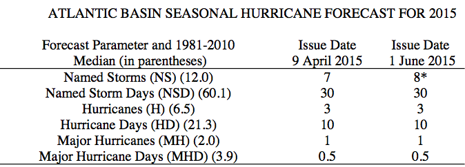
If we put everything together, we have atmospheric and oceanic conditions that suggest limited tropical activity, potentially to the levels of both 1992 and 1997. In fact, experts from Colorado State University (CSU) also believe this season will be inactive, even with the early development of Tropical Storm Ana back in May. The table below shows CSU’s forecast numbers for the 2015 season with median numbers in parenthesis.
At the very least, it looks like this is a good year to take a Caribbean vacation or a trip to the beautiful island of Bermuda! At this time, there are no suspect areas for tropical development for the next 48 hours, but we will keep you updated if that changes in the near future.
If you haven’t already done so, this would be a great time to follow us on Twitter or Facebook for frequent weather updates and subscribe to the site to get these posts automatically delivered to your email box (enter your email in the sidebar widget to right)!


