Hot and dry with mostly sunny skies. High in the low 90’s. In addition to today’s full forecast, continue reading for our outlook on the impending heat wave, and how the second half of June is likely to play out.
The ridge continues to build across our region. Get used to it…that will be the opening line in our DayCAST’s for the next several days! Notice the triumphant ridge visible in the 500 mb map below. It’s parked right across the center of the United States.
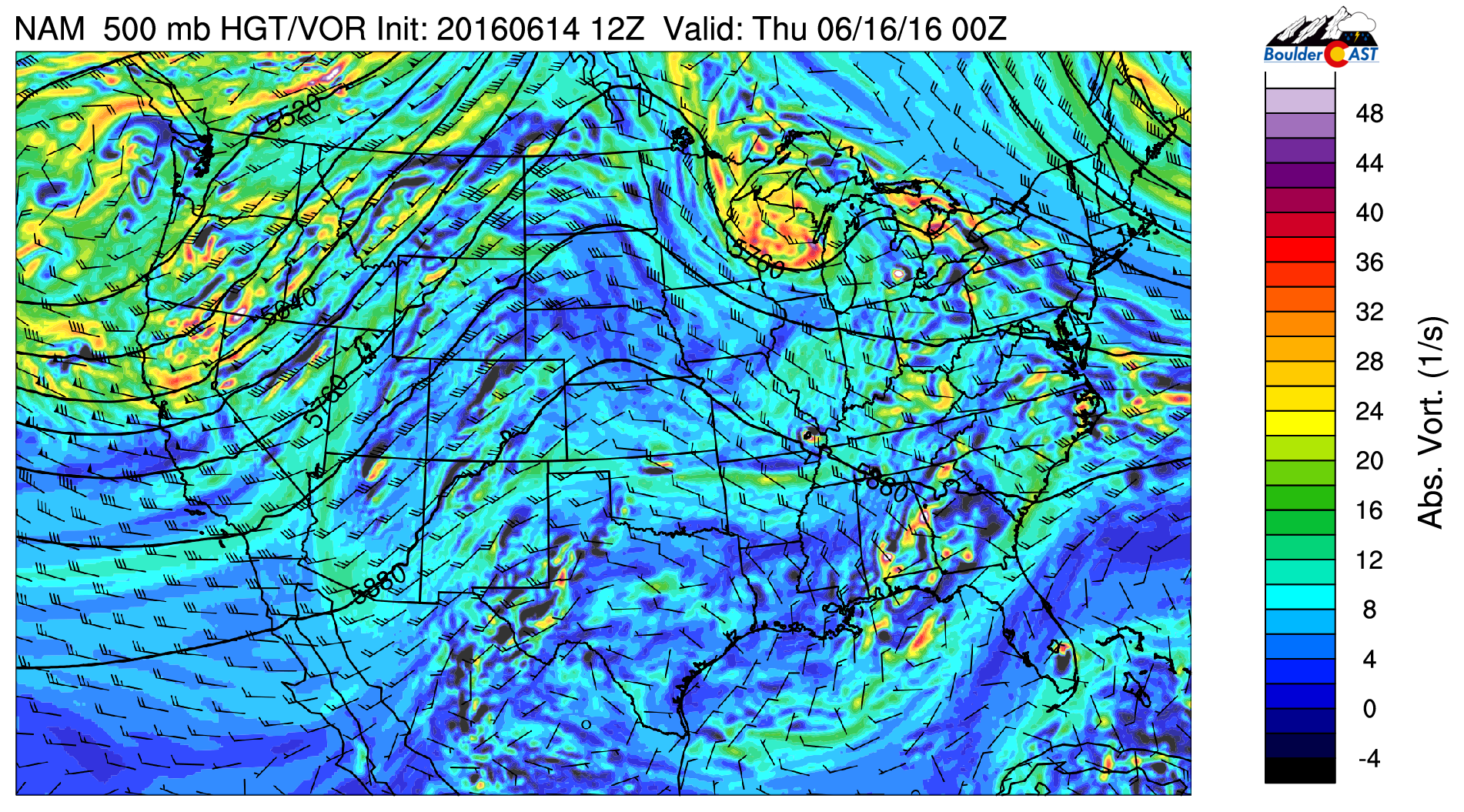
NAM model 500 mb vorticity map for this afternoon
As a result of this ridge (and the trough just off the Oregon coast), southwesterly flow dominates across Colorado. Ordinarily this would increase moisture to our region. However, the approaching airmass is very dry in the mid and upper-levels of the atmosphere. This can be seen in the precipitable water map below (which represents the total moisture content of the atmosphere).

NAM precipitable water and mean low-level winds for this afternoon
Lots of browns and whites across our region, with precipitable water values of 0.1 to 0.4″ widespread today across Colorado. This lack of moisture and large-scale sinking motion (from the ridge) will bring plenty of sunshine to the region today, alongside very warm temperatures. Expect highs in the low 90’s this afternoon.
This pattern will continue (and actually intensify with further drying and warming) as we head into the weekend. In fact, according to the long-range model guidance, there is fairly good agreement that this ridge could stick with us for weeks, not days. See the GFS ensemble forecast of 500 mb height below. Watch how the ridge evolves through the end of the month.
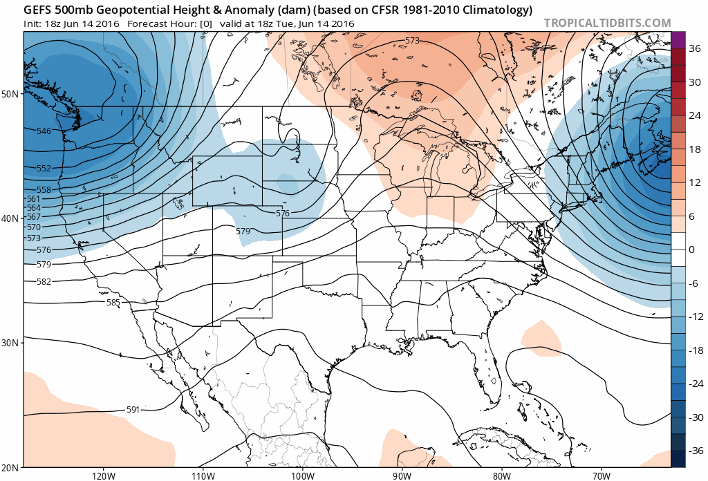
GEFS ensemble model forecast of 500 mb height for the next 16 days. With the ridge in place (lines forming a mountain shape across the region), temperatures will remain warm and conditions drier than normal.
The European and Canadian ensembles show a very similar evolution. We will likely be in store for a sweltering last half of June.
For those that don’t enjoy the heat, root for the CFSv2 model, which pushes the ridge further westward next week, opening the door for cooler air to slide into Colorado from Central Canada, shown below!
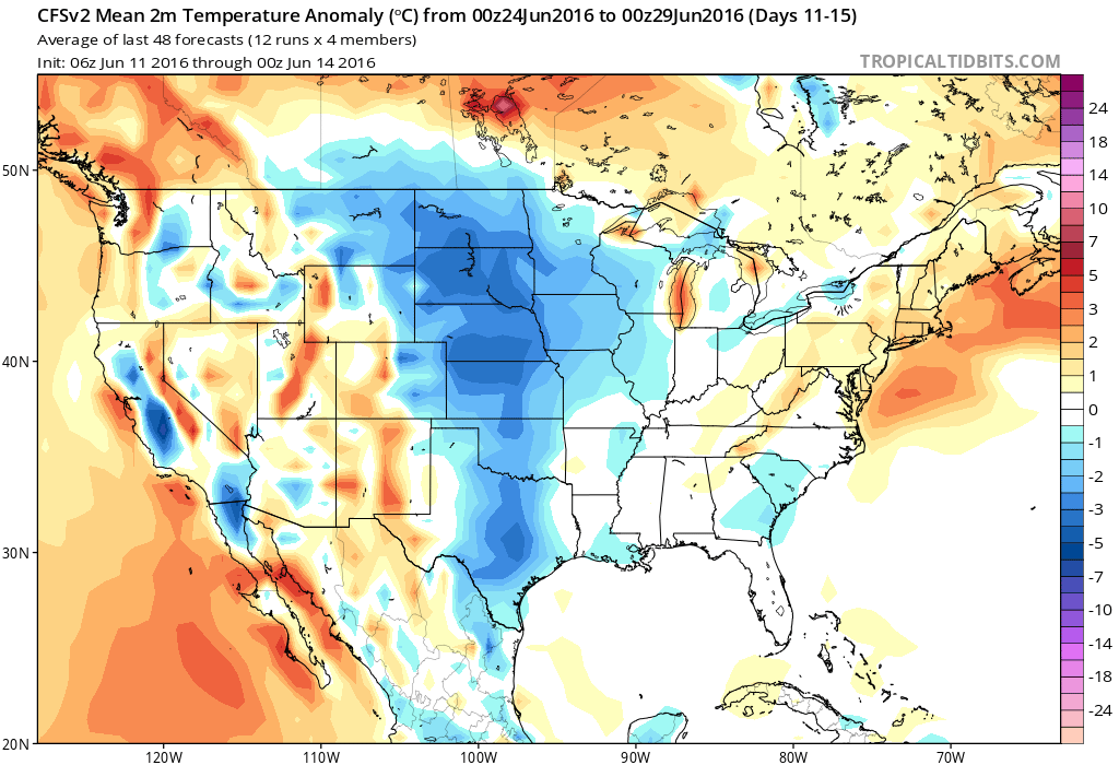
CFSv2 model forecast surface temperature anomaly for June 24-29.
Regardless of how the end of June plays out, the immediate future will be hot. Expect 90’s for the next five days, at minimum. Some model runs show a weak cold front moving through in the Monday/Tuesday timeframe, with no real chances for rain and temperatures still above normal. There is even the potential at some point before the end of next week to hit 100 degrees in some locations across northeast Colorado. Denver may be one of them. Stay tuned!
—
 Remember, DayCAST’s are Premium content. Periodically, we open this forecast up to all of our readers. Today is one of those days!
Sign up to become a Premium member today to get the best BoulderCAST experience, including daily forecasts, periodic video content, custom forecasts, an extended LiveCAST, early access to select content and much more! For a limited time, sign up and use the offer code BOULDER to get an additional $3 off an annual subscription!


