Category: Weather in the News (Page 1 of 15)
These posts cover interesting weather phenomena from around the world, and won’t be specific to Boulder County. However, Earth is very diverse in the world of weather, so you will surely learn a thing or two.
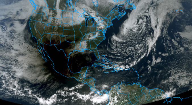
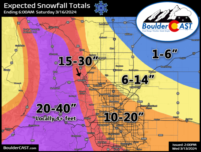
A high-impact, major El Niño snowstorm is about to unfold across the entire Front Range from late Wednesday into Friday. While we were a bit cautious of the eccentric model output over the last several days, all systems appear to be go for a significant, long-lasting dumping of heavy wet snow in the Denver Metro and nearby terrain. While there is still quite a range in the potential outcomes, we’ve seen enough to increase expected snowfall amounts across the board (again!). Read on as we sift through the latest model data and discuss the updated storm timeline and expected snowfall amounts. This one’s going to be a doozy!
Premium Storm Update (3/13/2024 8:00AM): The overarching forecast remains on-track as of Wednesday morning as a significant and highly impactful snowstorm bears down on the Front Range. Travel will become extremely difficult (and in some areas of the Foothills, impossible) Wednesday night into Thursday night, with some power outages expected. We wade through a wide gamut of the most recent model data, with trends suggesting a boom scenario is more likely than a bust. We also give our final thoughts on the impressive winter storm about to slam the Denver Metro area. READ HERE
Update (3/13/2024 3:00PM): The BOOM scenario has grown more favor with our team! As models continuing to trend upward on snow amounts, we’ve bumped up our official forecast totals a bit more. We’ve adjusted this entire post to be up to date with the latest information, including all graphics and discussion. BIG snow inbound! Be safe!
After our second snowy weekend in a row, things will stay quiet across the Front Range for much of the upcoming week with seasonal temperatures and lots of sunshine. However, that will change late-week as a quick-hitting Arctic cold front will surge south across the area. This front will likely be accompanied by at least a little bit of wintry precipitation, but the cold won’t stick around long at all. We also look ahead to several more devastating atmospheric river events set to slam California — their remnant moisture will likely spread into our Mountains to further bolster statewide snowpack. Read on for all the details.
September 2023 was an overall warm and dry month in Boulder, but technically we did finish with above normal precipitation. Almost all of that came on a single day as a result of a locally heavy thunderstorm. We’re yet to see a real autumn storm in the Front Range and as a result it hasn’t snowed yet outside of the Mountains, which is fairly normal with our average first snowfall not coming until mid October. Here’s a quick and colorful graphical recap of our weather during September and how it relates to climatology.
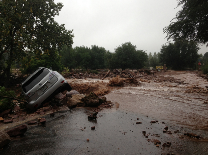
Ten years ago this week, torrential rains fell across the Front Range, triggering one of the worst floods in Colorado’s short recorded history, accompanied by a staggering repair bill now approaching $3 billion. With Boulder County at the epicenter of the disaster, the road to recovery has been long and arduous, and still continues today. We take a look back at this historic event, explain how it happened, and provide an update on related analysis performed since.
August 2023 ended up warmer and wetter than normal in Boulder — an uncommon pair of outcomes indeed. The summer monsoon failed to produce consistent precipitation across the state throughout the whole month (woefully dry in the middle), but most areas made out alright with drought still thankfully absent from eastern Colorado. The month had 14 90-degree days bringing the total count to 30 days year-to-date. Elsewhere, a DVD-sized hailstone that fell in far eastern Colorado was confirmed to be a new state record. Here’s a quick and colorful graphical recap of our weather during August and how it relates to climatology.
The Front Range has managed to ink out a cool and wet summer so far, but that wasn’t at all due to the monsoon. We discuss what has been causing the cool/wet weather of late and look ahead to when monsoon season may actually commence in Colorado. Spoiler alert: it’s sooner than you might think, but there’s a bit of a catch!
June 2023 dropped more than 5″ of rain on Boulder for the second straight month, concluding as the 4th wettest June since the late 1800s. Temperatures ended up nearly 4°F below normal as well, including a monthly minimum temperature of 42°F which occurred in the middle of the afternoon on June 12th as several inches of small hailstones lay melting on the ground. Other Front Range headlines in June included minimal Canadian wildfire smoke, the Highlands Ranch EF1 tornado, and the pummeling of giant hail at Red Rocks. Here’s a quick and colorful graphical recap of our weather during June and how it relates to climatology.

Liew View of Boulder

Current Conditions

Live Radar

Recent Premium Posts

BoulderCAST Daily – Sun 04/21/24 | Morning fog/clouds transition to afternoon sunshine and warmer temperatures
⦁❶⦁ Fog and low clouds make for a dreary start ⦁❷⦁ Sunshine and …
BoulderCAST Daily – Sat 04/20/24 | Snow tapers off around miday
⦁❶⦁ Snow tapers off around midday, but cold and cloudy skies persist through …
BoulderCAST Daily – Fri 04/19/24 | Rain changing to snow later today and tonight with several slushy inches possible
⦁❶⦁ Highs in the low 40s with showers will trend colder with snow …
3-Day Forecast

Air Quality

Trending Content


Live View of Boulder
Trending Content
© 2024 Front Range Weather, LLC