
Though only an inch or so of snow may have fallen in your area on Wednesday, upwards of 3 to 6 inches were reported within the city limits of Boulder. We take a look at the snow totals from yet another “light” snowfall event the struck the Metro area Wednesday afternoon and evening. We also look ahead to our next, potentially more significant winter storm targeting the Front Range for the upcoming weekend.
Storm Recap: Boulder does best again
Agander downward from space this morning via GOES-East showed that despite the focus on southern Colorado, yesterday’s snowstorm was also kind to most of northern Colorado as well. Nearly everywhere east of the Continental Divide picked up snow yesterday as seen in the below visible satellite image.

GOES-East visible satellite image from Thursday morning
There are a few clouds obscuring the snow cover in the above picture, but with a little band math, we can separate out the snow (blue) and clouds (white) in the below image. Nearly all of eastern Colorado had snow cover at sunrise this morning (and much of Nebraska and Kansas)!
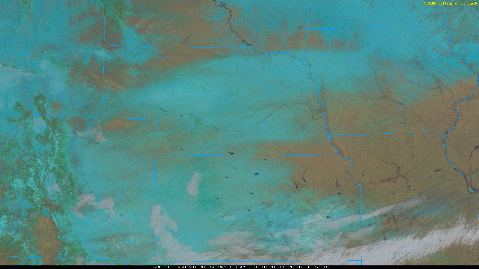
GOES-East natural color image from Thursday mornign. Blue is snow, brown is snow free, and white is clouds
The snow event on Wednesday played out about as we had forecasted. The onset of the snow (and lack of any freezing drizzle whatsoever) caught us a little of guard, but ultimately the snowfall rates during the mid-day and early afternoon hours were too light to produce much accumulation, except in the higher elevations. We talked about this slight oddity in the what actually happened to what was forecast in a Premium storm update Wednesday afternoon.
When the best upslope and lift arrived during the late afternoon and evening, snowfall quickly began to stick to roads and sidewalks with temperatures falling from the lower 20’s into the teens (aided by the setting sun of course). Light snow wrapped up in most locations before midnight with skies soon clearing which allowed temperatures to drop into the single digits and even slightly below zero in the lowest elevations northeast of Denver. We reported a low of +6°F Thursday morning at BoulderCAST Station.
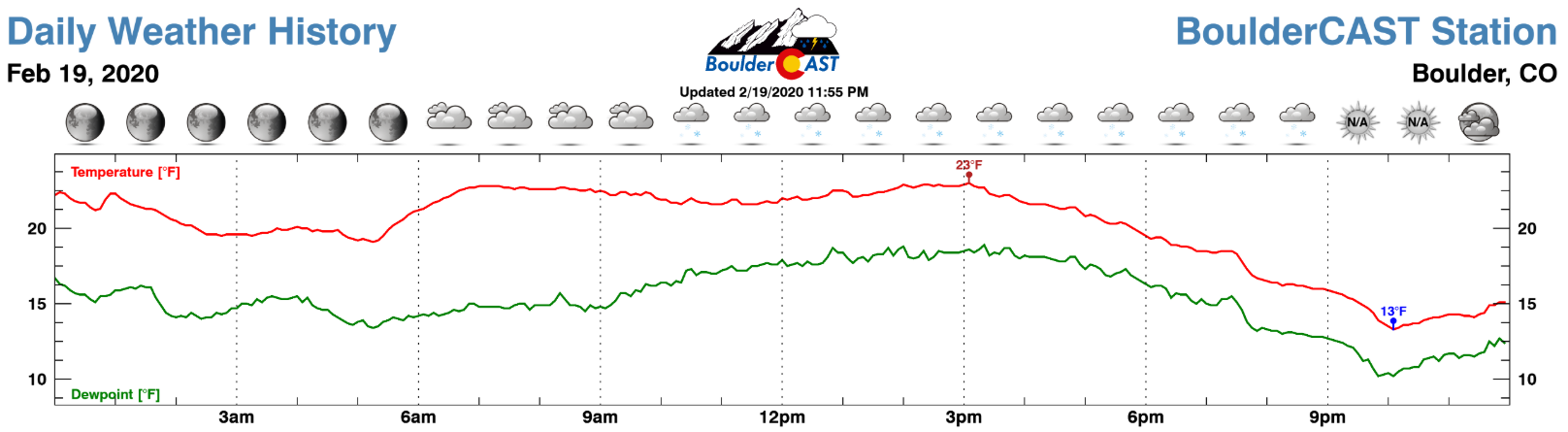
Weather observations from BoulderCAST Station through the day Wednesday
Shown below is our snowfall forecast map issued early Wednesday morning with actual storm totals overlaid in boxes. Green boxes indicate that our forecast verified to within one inch of the observed snowfall. Red did not.

Just as we discussed in our forecast, the highest totals were indeed right along the base of the Foothills (NOT in the Foothills) where the most efficient upslope was located. Boulder’s official snowfall report was 6.1″ at the NWS office right at the base of the Flatirons, though a bulk of the observations in the city fell between 3 and 5″. Elsewhere in the Metro area, generally totals landed between 0.5″ and 2.0″. Not a terribly impactful snowfall event for most of us, but the initial melting followed up by very cold overnight temperatures led to a lot of black ice and car accidents Thursday morning region-wide.
Boulder is rapidly approaching 100″ of snowfall this winter; currently we’re at 94.7″. Denver is also running quite above normal this season, but the total there so far is a much more modest 41.2″.
| Seasonal Snow Totals (Updated Feb 20 2020) |
|---|
| Boulder | Denver |
|---|---|
| 94.7" | 41.2" |
Not surprising in the least, but Boulder has a good chance at entering the snowfall record books again this year. The top 5 fastest seasons to hit 100″ in Boulder are shown below. We have almost two weeks to squeak out another 5.3″ of snow to secure second place. The added “Leap Day” this year has also slightly increased our odds!
- January 31 (2006)
- March 3 (2014)
- March 18 (1997)
- March 19 (2009)
- March 20 (1979)
Will we hit 100 inches this weekend?
Based on the results from yesterday’s poll, it seems that more of us are tired of snow than not.
.
Well, we’ve got some bad news for you: more snow is on the horizon! Even worse, the storm system we’re currently watching will not only target the Front Range over the upcoming weekend, it will be one that is much stronger and contains more moisture and relative warmth that anything we’ve dealt with of late. The upper-low in question is currently positioned well offshore of southern California. Over the next two to three days, this system will push eastward into the Four Corners area and move across Colorado on Sunday.

NAM 500mb height and vorticity forecast animation from Friday into Sunday
As the storm system spills over the Continental Divide this weekend, a comparatively strong surface low pressure will form somewhere in east-central or southeast Colorado. While not quite “bomb cyclone” caliber, if the storm intensifies quickly enough, we could see a period deep and very moist upslope here in the Front Range with cold enough air for it to be all snow. Everything we are seeing right now from model guidance suggests that this is very much a possible outcome. While we are always cautious of the forecast track of a cut-off low pressure system several days out (models are terrible at resolving this, typically), we have seen some agreement over the last day or two with this system. The NAM and the GFS (shown below) are the further north with the track right now. The Euro model is a little further south.
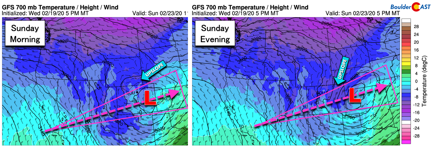
GFS 700mb temperature and wind forecast for Sunday morning (left) and Sunday evening (right). The potent track of the storm is still uncertain.
The two limiting factors on the weekend storm will be its speed and influx of warm air. Though the system is stalled over the Pacific Ocean right now, it will gain momentum and move across our area at a decent clip. Even if we do catch the favor of the upslope gods, it likely won’t persist for all that long, perhaps just 12 hours or so, before winds turn northerly and eventually northwesterly. Furthermore, the pipeline of deeper moisture getting wrapped into this mix comes at the cost of a warmer overall storm. While it does look cold enough for snow by most accounts in our area, there is a lot of warm air involved and we could just as easily see models trend warmer in the coming days and mix in some rain. At best, we’re looking at an all-snow event with low-end snow ratios (~10:1)

NAM model-derived snow level forecast for Sunday morning. While it appears cold enough for all-snow, this can change.
Considering everything, it’s impossible to say with any certainty exactly what will go down this weekend. We’re expecting good chances for snowfall sometime on Sunday, but amounts are unclear. The timing? Also unclear. Will the snow mix with rain? Probably not, but it could. Actually, it turns out this post is a less of a forecast and more of a “heads up”, at least for now!

The Arctic airmass currently digging its claws into our area will slide east on Friday allowing for a surprisingly prompt warm-up back into the 50’s with sunshine prevailing. A similar story will be told on Saturday, though cloud cover will be more prevalent. Chances of precipitation (mainly snow) increase considerably by Sunday, with much colder temperatures expected as well. If possible, schedule your outdoor activities early in the weekend, unless that activity is skiing, in which case, Sunday will be just perfect.
We’ll be sleeping with one eye open to watch the storm and will undoubtedly keep you updated. In the meantime, enjoy the brief lull in the wintry action, subscribe, and follow us on Facebook and Twitter.
Do you value the content provided by our team of expert Front Range forecasters? If so, consider supporting us by joining BoulderCAST Premium. We talk Boulder and Denver weather every single day. Sign up now to get access to our daily forecast discussions each morning, complete six-day skiing and hiking forecasts powered by machine learning, first-class access to all our Colorado-centric high-resolution weather graphics, bonus storm updates and much more! Or not, we just appreciate your readership!
Subscribe to receive email notifications for BoulderCAST updates:
We respect your privacy. You can unsubscribe at any time.
.
Spread the word, share the BoulderCAST snow forecast!


You must be logged in to post a comment.