Boulder picked up nearly 19″ of snow from the cluster of storms earlier this week and now has a very good chance of breaking its century-old seasonal snowfall record. We discuss why Boulder has seen so much more than Denver this snow season, and also comment on our next winter storm knocking on the door Wednesday night into Thursday.
T
hough the snow never really stopped in Boulder from around midnight Sunday until Monday evening, there were actually two distinct “storm systems” that brought snow to the Front Range during this time associated with a late-season Canadian trough which overtook the entire country (except south Florida) just in time for Easter.
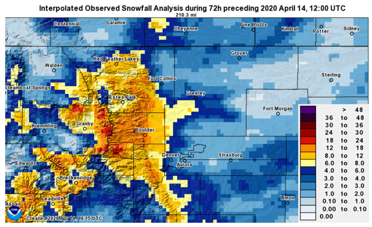
Combined the two systems produced some absolutely booming snow totals across the northwestern Metro area, particularly in Boulder which recorded a staggering total of 18.7″ of snow. The storm total snowfall analysis map below shows that there were large differences in snow amounts across the Denver Metro area. Denver’s official report from DIA for the duo of storms was a mere 1.0″, whereas totals closer to downtown ranged from 2 to 4″.
The discrepancy of snow this week between Boulder and Denver is nothing new. In fact, Boulder will do better than Denver in almost any winter storm Mother Nature can throw at us. This is because Boulder sits in the premier geographic location for snow, definitely the best of any “Plains” city across the Front Range. The sharp rise of the Flatirons is the first significant obstacle easterly upslope winds encounter. This rise of 3000 feet straight up on the west end of Boulder is the largest of anywhere in the Metro area. Of course, it also helps that Boulder’s official climate observation site is directly at the base of Green Mountain on South Broadway. There is often a discernible snowfall gradient from west to east across the city of Boulder, with snowfall amounts on the far west side of town some 50 to 80% higher than the far eastern side.
For storms like this past Easter Sunday, the conditions were just right to have localized and extreme upslope enhancement. Sometimes this enhancement is shallow, just like Sunday and Monday, and this is when the weather models struggle the most. You can tell this enhancement is happening in Boulder when you look outside and there is moderate to heavy snow falling and huge flakes, but the radar from Denver is showing very little. Even the lowest radar beam sometimes isn’t able to pick up the shallow in-cloud enhancement of snow occurring over Boulder just 30 miles away. This scenario happens many times per year, and the results can produce seemingly impossible dumps of rain and snow in Boulder.
Even still, we are a bit taken-aback that Boulder managed nearly 19″ of snow and 1.25″ of liquid equivalent (melted snow) Easter Sunday into Monday (all without a single winter highlight from the National Weather Service, by the way!). There wasn’t a shred of weather model evidence indicating that much moisture was even possible. Maybe there was a few days beforehand, but models all trended drier as the storm approached. What Boulder picked up was slightly beyond the scope of any model and even our skillful team of Front Range forecasting experts.
There is one exception to the rule, where Denver actually can do better than Boulder in a snowstorm. That is when a deep surface low develops somewhere between DIA, Colorado Springs, and Limon. In this scenario, the heavy snow associated with the deformation zone on the northwest flank of the low can dump on DIA, while Boulder gets north-northwesterly downslope and much lighter snow overall. This scenario only really happened twice so far this season, back on October 29-30 & December 27-28 . These two storms certainly weren’t great examples, with Denver barely besting Boulder in snow both times. A more notable example was the March 2019 Bomb Cyclone.
Several of these type of storm systems each winter can help curb some of the “snow gap” between Denver and Boulder, but it really didn’t this season. As it stands, Boulder has seen nearly 7 FEET more snow than Denver…a total of 134″, compared to Denver’s 55.7″.
| Seasonal Snow Totals (Updated April 14 2020) |
|---|
| Boulder | Denver |
|---|---|
| 134.3" | 55.7" |
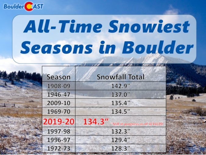
The massive dump of snow this week allowed the 2019-20 Snow Season to leap-frog more than dozen competing efforts. This year now sits as the #5 all-time snowiest season in Boulder. As you can gather from the list below, we only need another 8.8″ to eclipse the existing record set more than 110 years ago.

For a complete summary of all the 2019-20 snowstorms in the Denver Metro area, click HERE. Feel free to compare the snow totals in Boulder and Denver for each event. In typical fashion, we promise you won’t find many where Denver wins out!
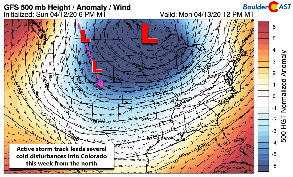
Finally, surely by now you know there is another winter storm knocking on our door set to arrive Wednesday night and continue through Thursday. This one could very well produce those needed 8.8″ of snow in Boulder, boosting this snow season to the top of the record books!
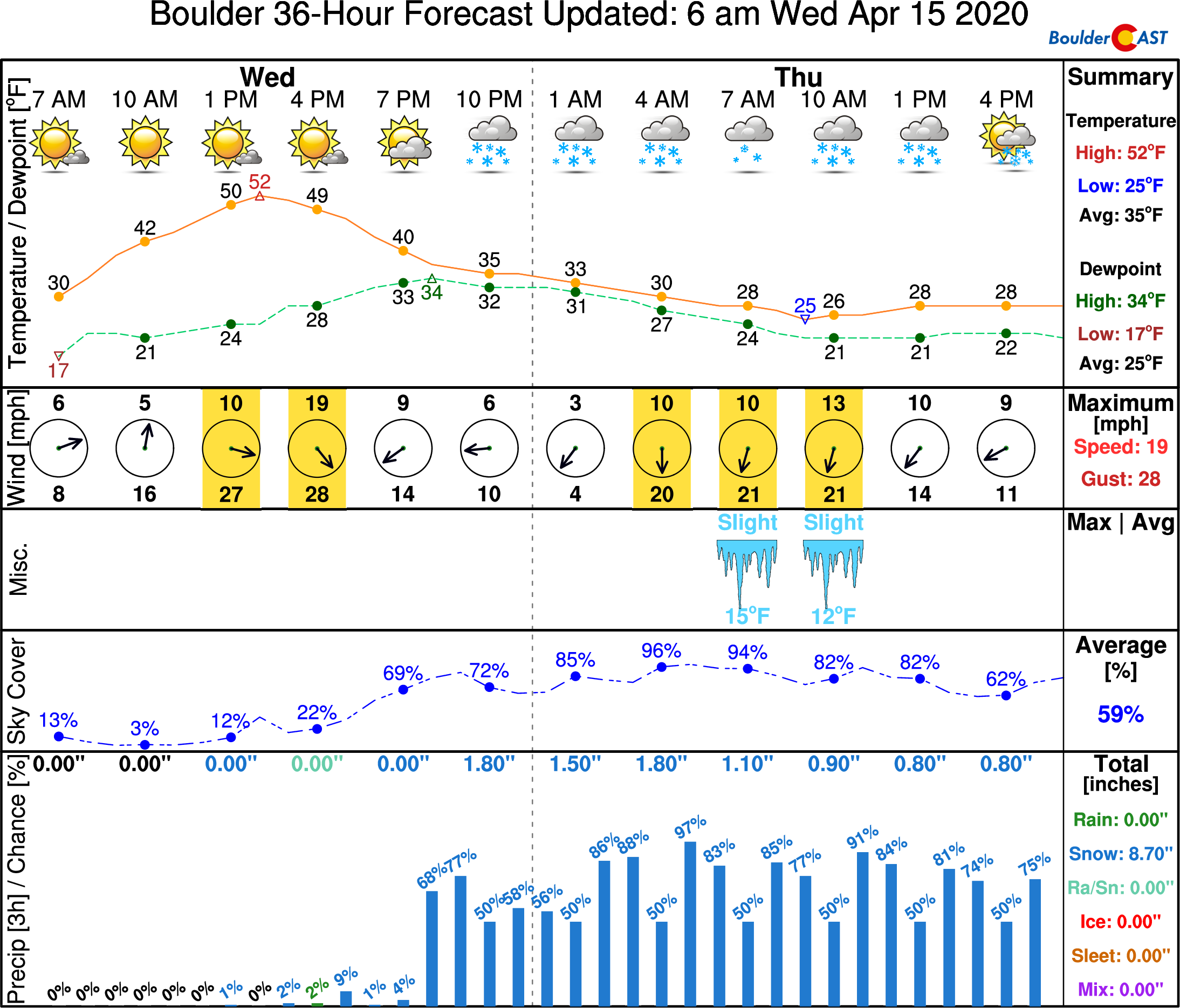
There is still a surprisingly large amount of uncertainty and a complicated atmospheric set-up making quite a mess of this late-season snowfall forecast. Our team is still fine-tuning the forecast and will need to look at a few more model runs before issuing our final snowfall forecast later this afternoon. To hold you over, here’s the latest meteogram for the storm…
and here’s short excerpt from our daily Premium forecast discussion earlier this morning:
Potential accumulations appear to be up to 2-5″ in much of Denver, 5-10″ in Boulder and 7-14″ in the Foothills, but could be higher or lower given the uncertainty. We suspect to see the winter highlights from the National Weather Service grow to encompass at least some of the Denver Metro area given the southward shift in the models of late.
Subscribe or check back for updates on the impending winter storm later today!
Help support our team of Front Range forecasters by joining BoulderCAST Premium. We talk Boulder and Denver weather every single day. Sign up now to get access to our daily forecast discussions each morning, complete six-day skiing and hiking forecasts powered by machine learning, first-class access to all our Colorado-centric high-resolution weather graphics, bonus storm updates and much more! Or not, we just appreciate your readership!

Spread the word, share this post:
Subscribe to receive email notifications for BoulderCAST forecast updates:
We respect your privacy. You can unsubscribe at any time.
.


You must be logged in to post a comment.