Our recent stretch of warm weather is nearing its expiration this afternoon across Colorado. The ridge is breaking down and a new storm system is coming ashore in Washington and Oregon. This trough of low pressure will dig into Colorado on Tuesday, bringing with it widespread unsettled weather to our state. We discuss when precipitation will commence and who will be seeing snow (and of course, how much!).
*PREMIUM STORM UPDATE* A better overlap between efficient upslope and colder air expected this evening and overnight. Thus, we bumped up snow totals a tad. READ NOW
The 500 mb height anomaly animation below is from the GFS ensembles. The core of the energy from the trough will dive quite far south and move into northern New Mexico by Wednesday morning.
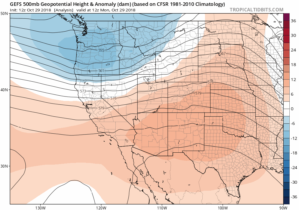
GFS ensemble 500 mb height animation covering Monday afternoon into Thursday morning.
You can see a plethora of precipitation breaking out already across the Pacific Northwest and Northern Rockies Monday afternoon in response to this trough:

Radar animation of the Pacific Northwest Monday afternoon. Lots of precipitation occurring upstream to Colorado.
We’ll see the impacts of this system begin across the Mountains late Monday night and across eastern Colorado during the morning hours Tuesday. The track of the storm is not necessarily ideal for the Metro area, with much of the energy skirting by to our south. Nonetheless, we will catch at least a glancing blow as it moves across the state. We will say that the track has been drifting northward in the last 24 hours or so.
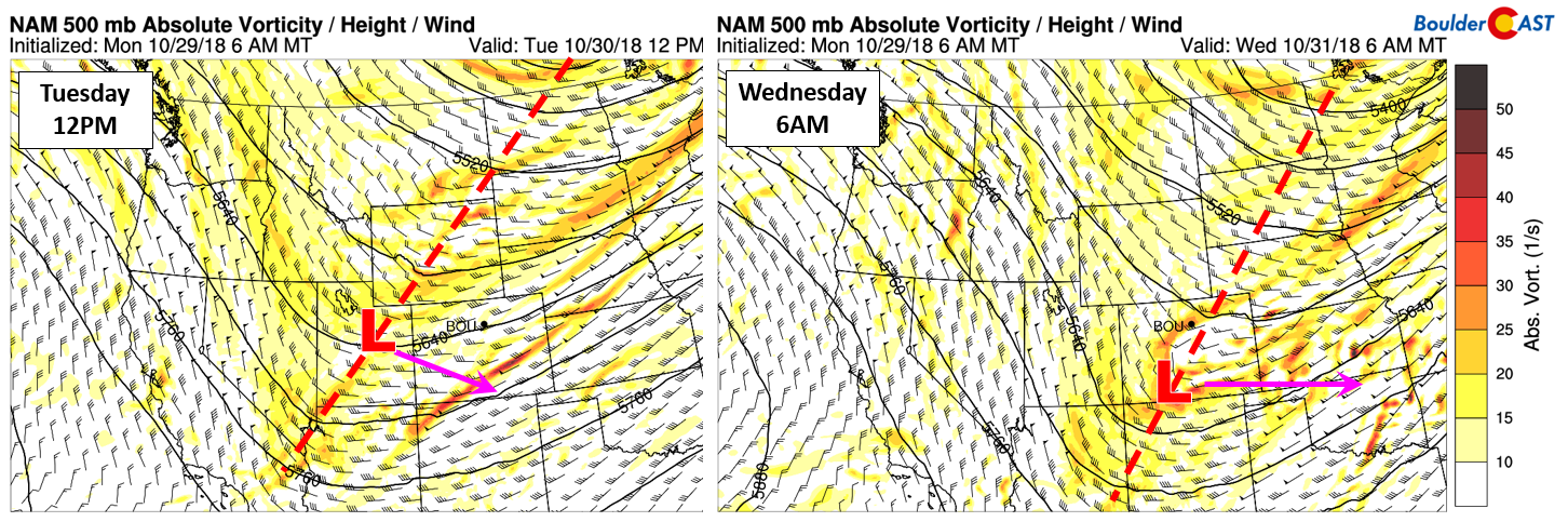
NAM 500 mb vorticity forecast for Tuesday afternoon (left) and Wednesday morning (right)
The first sign of the approaching storm will be the cold front moving into the Denver Metro area Monday evening between 8:00 and 10:00 PM. After a high near 80 degrees (yep!), temperatures will be dropping into the 40’s and eventually the 30’s by Tuesday morning. Upslope will then ensue and linger into early Wednesday morning for most of us.
The onset of the precipitation will likely be around sunrise Tuesday morning for the northern Metro area. A narrow swath of moisture and favorable jet dynamics (see below) will align to produce banded precipitation during this time.
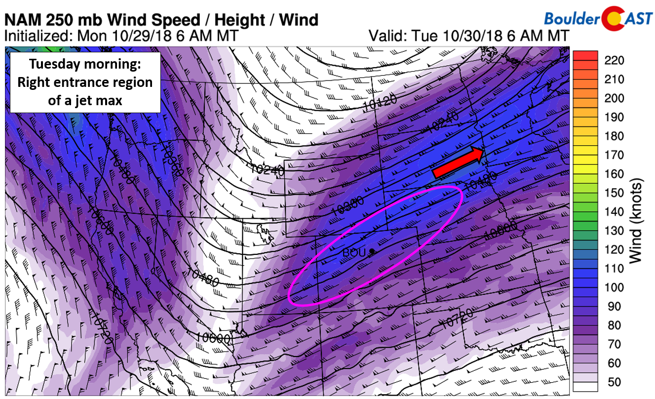
NAM 250 mb wind forecast for Tuesday morning
The latest HRRR radar depiction shows one or two elongated bands spanning from southern Utah through Boulder Tuesday morning.
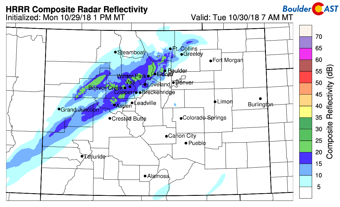
HRRR simulated radar for 7:00 AM Tuesday showing banded precipitation associated with the jet
The approaching storm has roots mainly in the northern Pacific Ocean, as opposed to Canada. As a result, it won’t be packing quite the punch of cold air we saw last time it snowed more than two weeks ago. Snow levels will begin near 6000 feet and waver between there and Plains-level through the daytime Tuesday.

NAM model-derived snow level forecast for Tuesday at sunset. Snow levels around 5500-6000 feet all day Tuesday.
However, colder air will filter in aloft through the day from the north. This should help lower snow levels as the day progresses, especially as a secondary surge arrives late in the afternoon or evening. Still, temperatures at the surface will be in the middle to upper 30’s for much of the day on Tuesday, marginal for snow accumulation. However, by Tuesday evening, 700 mb temperatures decrease further to around -8 degC with stronger NNE-erly upslope indicated. Both the GFS and NAM models agree on this facet, surprisingly well.

700 mb temperature and wind forecast for Tuesday night at midnight from the GFS (left) and NAM (right).
Thus, while rain/snow will be mixed through much of the day Tuesday for the lower elevations with minimal accumulation expected, we should see a full change-over to snow Tuesday evening and night. We could see an inch or two during this time, especially on the southern and western fringes of the Metro area. Snow will generally be light, with a few moderate snow bands mixed in.
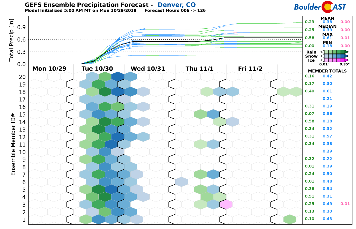
Latest model trends have been climbing a little higher in terms of precipitation amounts for both Boulder and Denver in response to an ever-so-slight northward shift in the storm’s track. Right now the magic number is about 0.5″ of liquid for the region, with upwards of 1″ indicated in the Foothills.
Much of this will fall as rain or a rain/snow mix, or even snow that mainly melts throughout the day on Tuesday. We really like the look of the GFS snowfall forecast map below. However, it is important to keep in mind accumulation in the Metro area will be lower due to most of what falls melting on contact, at least during the day Tuesday. In the Foothills and over the Palmer Divide where temperatures will be mainly below freezing, the amounts shown below become more realistic. There is a clear southern bias with this storm which has been the case all along in the models. There’s no disputing that.

GFS model-derived snowfall forecast for the event. Totals across the lower elevations are biased high, not truly accounting for melting.
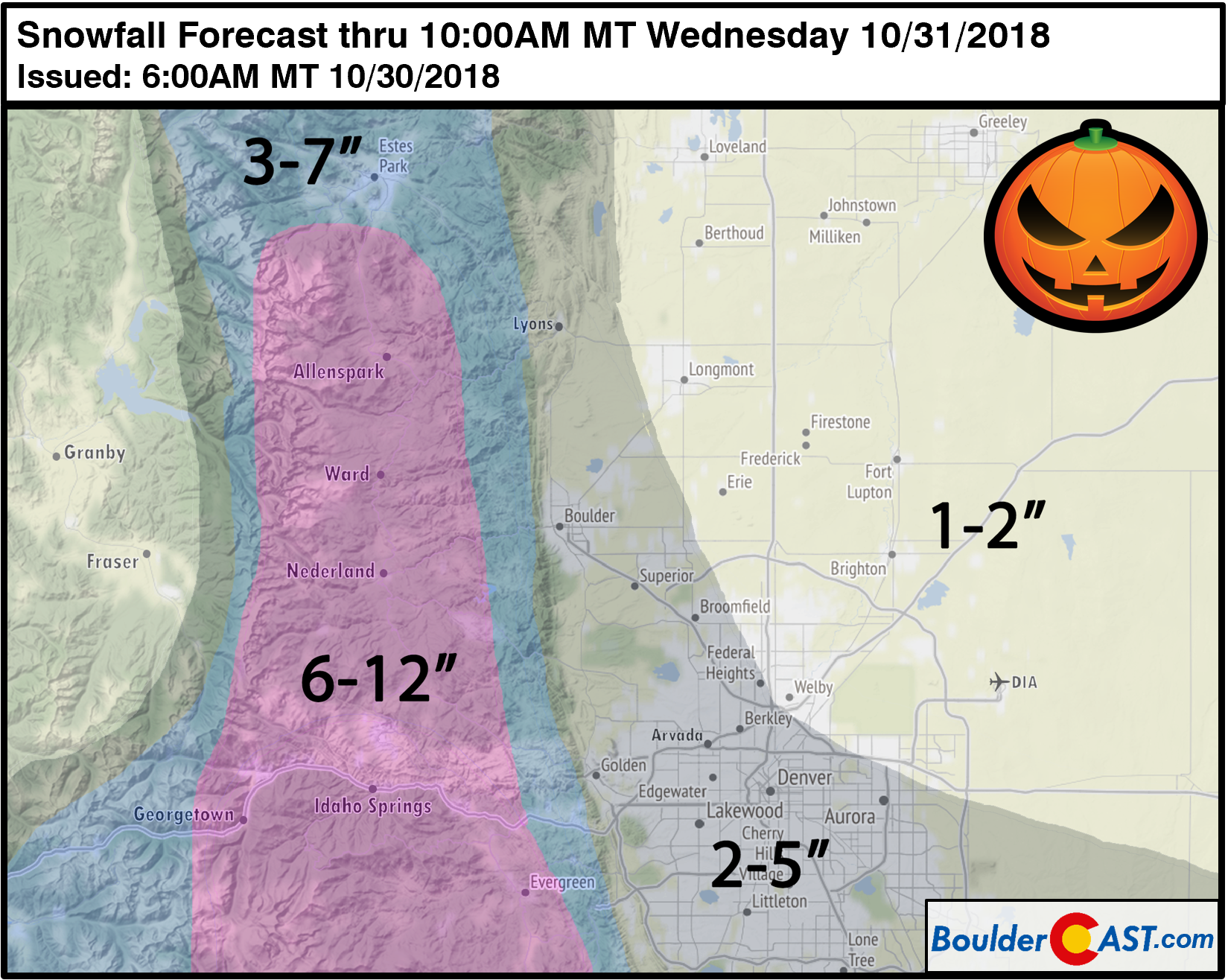
Here is our snowfall forecast for Tuesday into early Wednesday (updated Tuesday morning at 6:00AM). In general, we’re looking at a couple inches for the Metro area, with areas south and west standing the best chance of seeing several inches of snow for Halloween. Favorable upslope, colder temperatures, and fluffy snow ratios will produce totals ranging from 4 to 10″ in the Foothills, with possibly some areas picking up close to a foot. Let it snow!
There is light at the end of the tunnel, though. Mother Nature will get the ugly weather over with Tuesday and Tuesday night, paving the way to a cool but decent Halloween evening for all the tricker-treaters!
Enjoy the White Halloween!
Share this snowy and spooky forecast:
.


You must be logged in to post a comment.