During Episode 5 of the BoulderCAST Podcast, the hosts discussed the size classifications of severe hail, but only briefly mentioned how meteorologists are able to estimate that size from radar. Alex V., a follower from Lafayette, contacted us for more information on the topic, so we thought we would share!
The question: How exactly do meteorologists know the size of hail in a thunderstorm from radar measurements?
– Alex V. (Lafayette, CO)
To start, in simple terms, radars send out a pulse of microwave radiation and then measure the power reflected back, called the reflectivity. Since the speed of light (including microwaves) is nearly constant through the atmosphere, measuring the time between when the pulse was emitted and received back allows the distance to be calculated. The amount of returned power tells you something about what the microwaves were reflected by. The usefulness of radar for weather applications was first realized during World War II, when military radar operators noticed meteorological signatures on radar when scanning for enemy aircraft. More importantly than just detecting the presence of precipitation, the amount of backscattered signal is proportional to the intensity of precipitation. Weather radars were born!
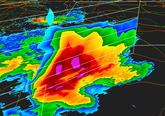
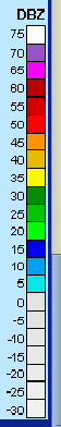 Similar to estimating the intensity of rain or snow, hail size can be approximated based not only on the amount of returned power, but also from the location of the signal within the storm. Radar reflectivity is roughly proportional to the size of the particles to the sixth power, causing larger particles to have a much more significant influence on returned power, as well as the need to define a logarithmic scale for reflectivity (dBZ). Reflectivity generally ranges from 10 to 25 dBZ for light rain, 25 to 40 dBZ for moderate rain, and 40+ dBZ for heavy rain. Large hail sends an extraordinary amount of power back to the radar, and therefore can have reflectivity values from 55-70+ dBZ. Difficulty arises when attempting to locate hail smaller than 2″ in diameter due to uncertainty in the size distributions of the reflecting particles. An identical reflectivity signature can be produced by comparatively small amounts of severe, 1.5″ diameter hail, and for very intense rainfall made up of a huge amount of smaller rain drops. However, reflectivity above 65 dBZ almost certainly contains 2″+ hail, as rain drops alone cannot produce a return signal that large.

In order for severe hail to form (>1″ in diameter/quarter-sized), strong updrafts must be present, which only occur in powerful thunderstorms. As hailstones grow, the pull of gravity must be balanced, or exceeded, by the updraft velocity, so that the stones are suspended and can grow within the cloud. Imagine how strong an updraft must be to suspend softball-sized hail! Meteorologists typically integrate radar measurements with other metrics to gauge whether hail is present and what the likely maximum size would be. Due to inherent properties of water, the area of a cloud between 0 and -20 degrees Celsius is the most likely location for hail to form, so pin-pointing the reflectivity at those heights in the cloud is a good first-order approximation for hail size. Including updraft velocities in the estimation is also important, for reasons outlined above. This is all done through the use of computer algorithms. After crunching the numbers, statistical probabilities are output, for such things as the presence of hail, the probabilities of various hail sizes, and the likely maximum hail size. This can all be done before the dangerous hail stones even begin falling to the surface, providing valuable time to warm the public.
So there you have it! Estimating the size of hail using radar measurements is not an exact science, but it is vital to warning to the public, despite the elevated occurrence of false-positive forecasts of hail less than 2 inches in diameter. Hail causes nearly a billion dollars in damage to property and crops annually in the U.S, significantly more than tornadoes. This motivates research to constantly improve radar hardware/techniques and algorithms to detect hail more effectively. Next time you notice the NWS-Boulder office issue a Severe Thunderstorm Warning for ping pong ball-sized hail, you will know how they get their information to make such a claim!
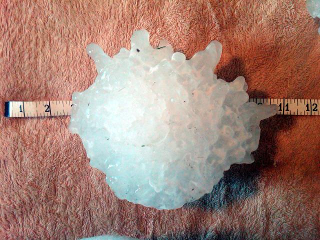
For those of you wondering, the hailstone depicted in the first image is the world’s largest hailstone on record. It fell in Vivian, South Dakota on July 23, 2010, and weighed in at 1.94 pounds and had a staggering diameter of 8.0″, nearly the size of a soccer ball! The stone was likely even larger, as there was a sizable delay between when it landed and the official measurement, lending time for sublimation or melting to occur. This hailstone, along with many other large stones, are permanently stored at the National Center for Atmospheric Research in Boulder!
If you would like your weather-related question answered by our experts, feel free to contact us by email at contact@bouldercast.com, or by posting in this forum. As always, be sure to follow/like BoulderCAST on Twitter or Facebook to receive up-to-the-minute weather updates and information. You can also subscribe to the main site to be notified via email of new posts (look for the Subscribe widget in the sidebar to the right). And finally, be sure to check out our podcast.


