With the conclusion of last night’s quick-hitting snow event, our fourth in just the last eight days, Boulder has now officially eclipsed the typical amount of snow that falls in an entire season, and we’re not even half way through the month of February! We take a look at how this fits into Boulder’s history, what it might tell us about the potential for snow the rest of the winter, and give a quick and dirty forecast for our next chance of snow coming on Wednesday.
A surge of northeasterly upslope, moisture, and lift from a passing shortwave came together to produce an impressively intense but brief shot of snow to the Front Range Monday evening. Accumulating snow largely held off in most areas until just after rush hour, which likely made the commute home not too bad. The same can’t necessary be said about Tuesday morning’s drive, unfortunately.
Just like Sunday’s storm, this was one of the shortest periods of snow you will ever see here. An eight-hour radar animation from Monday evening is shown below. There wasn’t much organization to the snowfall apparent on radar. It was mainly just a conglomeration of light and moderate snow with tiny embedded cells of heavy snow. You can, however, notice a clear movement of the radar echoes from northeast to southwest following the direction of the upslope in the lower atmosphere.

Radar animation from the Denver area Monday Feb 10th in the evening as snow fell.
During the tail-end of the storm, a culmination of ingredients led to a brief spike in snowfall rates along the terrain across the western Metro area. This is visible in the animation above as a well-defined north-south oriented pocket of heavier snow at the very end of the radar loop. This darker green coloring had snowfall rates near 2″ per hour between 10:00PM and midnight along the base of the Foothills. As you will soon see, this wave of terrain-forced heavy snow boosted totals in this localized area slightly above our forecast.
Shown below is the BoulderCAST snowfall forecast map issued Monday morning with actual storm totals overlaid in boxes. Green boxes indicate that our forecast verified to within one inch of the observed snowfall. Red did not.

The official snowfall observation from the National Weather Service office in Boulder was 8.5″, though amounts across the city spanned from 5 to 8″. DIA reported a lesser 1.8″, with the rest of the Denver Metro area falling in the 1 to 3″ range as well. Our 2-5″ forecast in the western Metro and Foothills held up okay, but the brief burst of heavier snow at the very end of the event led to higher totals for elevations between 6000 and 8000 feet, and also in Boulder-proper which got hit with a particularly heavy cell of dendritic snow around 10:00PM Monday night.
A season’s worth of snow in just half a season?
The 8.5″ of snowfall reported on Monday evening pushes Boulder’s snowfall total this season to 89″. That’s more than 7 feet! With this, we have already surpassed our average wintertime snowfall amount of 85″…in spite of the fact we’ve also endured one of the longest dry stretches in Boulder’s historical record this winter (12/28/2019 – 02/03/2020; 37 days)!
| Seasonal Snow Totals (Updated Feb 11 2020) |
|---|
| Boulder | Denver |
|---|---|
| 89.2" | 35.4" |
So far this winter is the 4th fastest in Boulder’s history to eclipse the amount of snow that should fall in the ENTIRE season, shown in the table below.
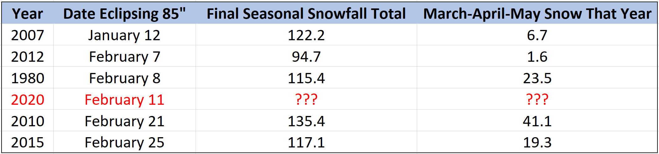
The right-hand column shows the amount of snow that fell in the following months of March, April and May each year on the list. For reference, the average snowfall in Boulder for these three months combined should be around 31″. It’s clear from looking into Boulder’s past, years where snowfall was most prolific during the first half of the season typically had abysmal showings of springtime snow. The most recent year on the list, 2012, had just 1.6″ of total snowfall during the spring in Boulder setting a handful of both temperature (warm) and precipitation (dry) records during this time. Do you remember the consequences we suffered that year? Let me give you a small hint: unrelenting flames engulfing pine trees.
All hope is not lost for the spring this season….the Front Range isn’t necessarily spiraling towards a fate of drought and fires this summer. Cherry-picked climatology can only get you so far, especially from just a single point like Boulder. We also must take a look at what the long-range models are showing and see what climatologists are expecting.
First up, a look at the Climate Forecast System model (below). We already see some signs of hope. The model is currently predicting a colder and wetter than normal month of March for northeast Colorado. While the model also predicts a warmer than normal April and May, there are no signs in the forecast of especially dry conditions.

The NOAA Climate Prediction Center (CPC) is forecasting elevated odds of above normal temperatures during the March-April-May period in all of Colorado, with equal chances of any precipitation anomalies occurring (below). While this may seem to suggest less snow (and more rain) due to the overall warmth, as we have come to expect here in Front Range, no magnitude of “warm before the storm” can stop a Canadian cold front and subsequent snowfall during our transitional seasons.

We expect continued ENSO-Neutral conditions in the Pacific Ocean through the spring and into the summer months, just as the case has been all winter long. As a dominant climate influencer for much of western North America, ENSO being nullified leaves us with especially low confidence in any long-range predictions, both by models and the climatologists that interpret them. We suspect that any forecast for this timeframe has only marginally higher skill than decadal global warming trends. That is, temperatures this spring are mostly likely to be warmer than the 1981-2010 climatological record simply due to global warming. Whether we end the winter season with a continued feast of snowfall or not, there’s certainly no cause for concern yet.
No rest for the weary, more snow for Wednesday
The active weather pattern that has been delivering frequent bouts of snow since Groundhog Day to our area will continue for a little while longer. The GOES-East infrared satellite animation below from today is looping below. As you can see, we’re experiencing beautiful conditions across the state with clear skies since Colorado rests in between storm systems!
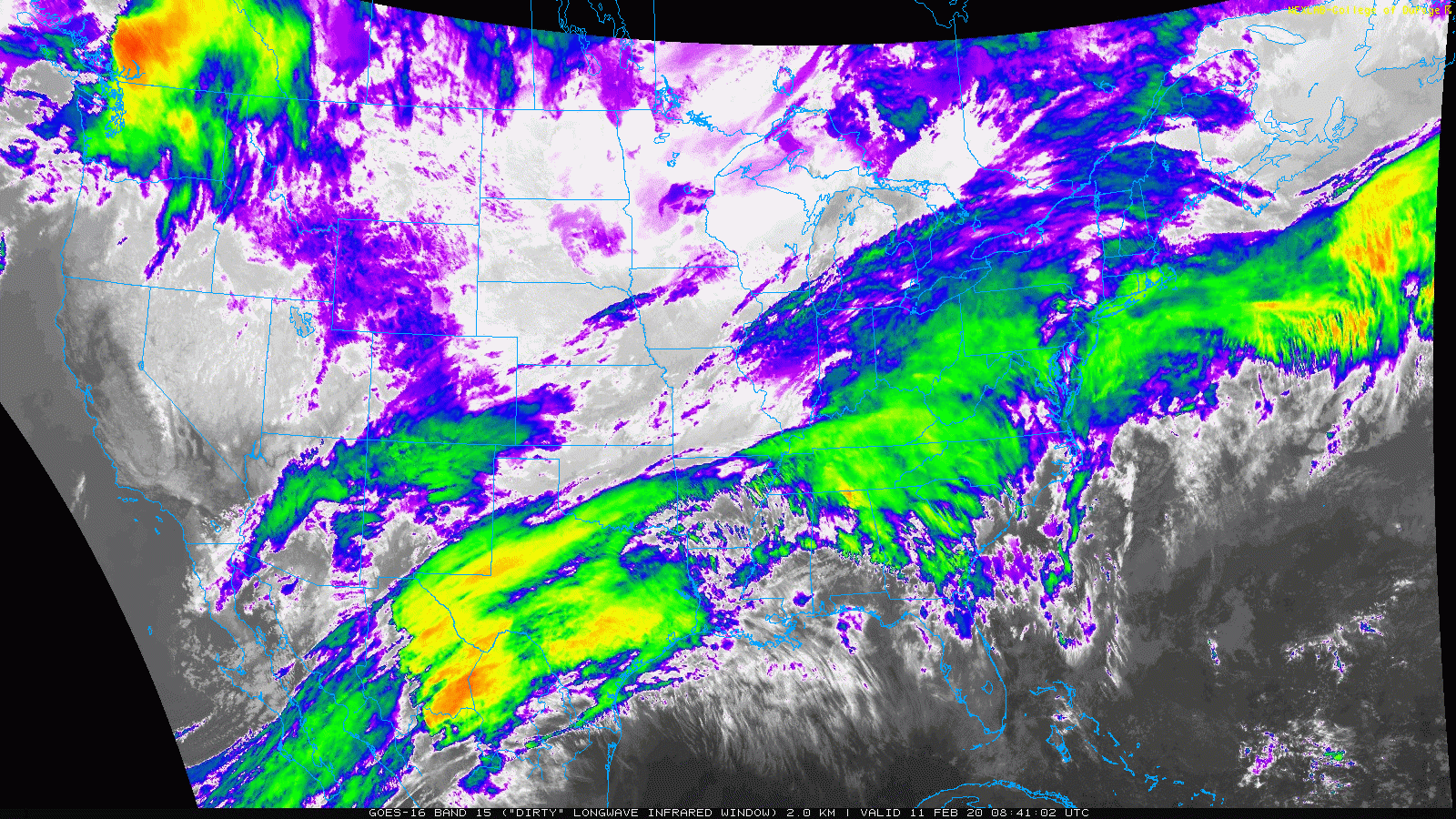
GOES-East infrared satellite animation from Tuesday afternoon.
The reprieve will be short, however. Our next shortwave is already gearing up across Montana (see above) and will pivot into Colorado during the day on Wednesday. At this time, moisture and low-level upslope all look borderline with this disturbance, though there could be some weakly favorable jet dynamics passing by alongside an unstable atmosphere.

NAM 500mb vorticity map for Tuesday evening showing two storm systems. Can you match these storms to the satellite animation earlier?
Look for highs on Wednesday in the middle 30’s before a strong afternoon cold front passes. Thereafter, gusty north winds and a chance of afternoon and evening snow showers will be possible for our region. A few flakes up to 2″ of snow is our current forecast. However, we are monitoring the potential for localized banded snow across the region related to the overhead jet and instability. High-resolution modes currently target a line stretching from Lakewood to Nederland and over the western Metro area with these potential snow bands. We’re a bit skeptical of where all the moisture to support the bands is coming from, but we will nonetheless mention the possibility. Should these pockets of heavier snow materialize, localized areas can expect 2-6″ of snow by Wednesday night.

High-resolution HRRR model-derived snowfall forecast for Wednesday afternoon into evening. Some isolated heavier snow bands are indicated
—
We discuss Boulder and Denver weather every single day on BoulderCAST Premium. Sign up today to get access to our daily forecast discussions every morning, complete six-day skiing and hiking forecasts powered by machine learning, access to all our Front Range specific weather models, additional storm updates and much more!

Subscribe to receive email notifications for BoulderCAST updates:
We respect your privacy. You can unsubscribe at any time.
.
Spread the word, share this informative post about Boulder weather!


You must be logged in to post a comment.