We’re starting to sound like a broken record, but more snow is on the way later today into tonight. Read our latest thoughts on the forecast which will produce light accumulations across the Front Range once again.
PREMIUM UPDATE (11:00 AM Wed 02/19/20): Wednesday morning’s model runs came in a little snowier, but are they being overly optimistic? We take a look at the latest model data in conjunction with satellite/radar observations to find out. Click HERE to read.
A
hh, it seems like just yesterday that we were talking light snow for the area related to a quick-moving but ultimately weak weather system dropping out of Canada. Wait…that WAS yesterday! As if we should expect anything less: the incoming wave will be our SEVENTH snowfall producer of the month. Ironically, our recent snowy stretch began the very day after the all-wise groundhog Punxsutawney Phil tipped us off that spring was coming ahead of schedule this year. So much for that!
Similar to what transpired on Monday evening, another elongated and positively tilted shortwave trough will scream southward out of Canada and sweep across the central Rockies on Wednesday. This system isn’t extremely worrisome for us, despite it being noticeably stronger, colder and more moist than its predecessor. An accompanying surface cold front will plow southward across the Front Range Wednesday morning as well, packing a bit more of a punch than what we’ve seen of late. Temperatures will hover in the 20’s if not fall slowly throughout the day. We’re also expecting gusty northeast winds behind the front of 10-20 mph.
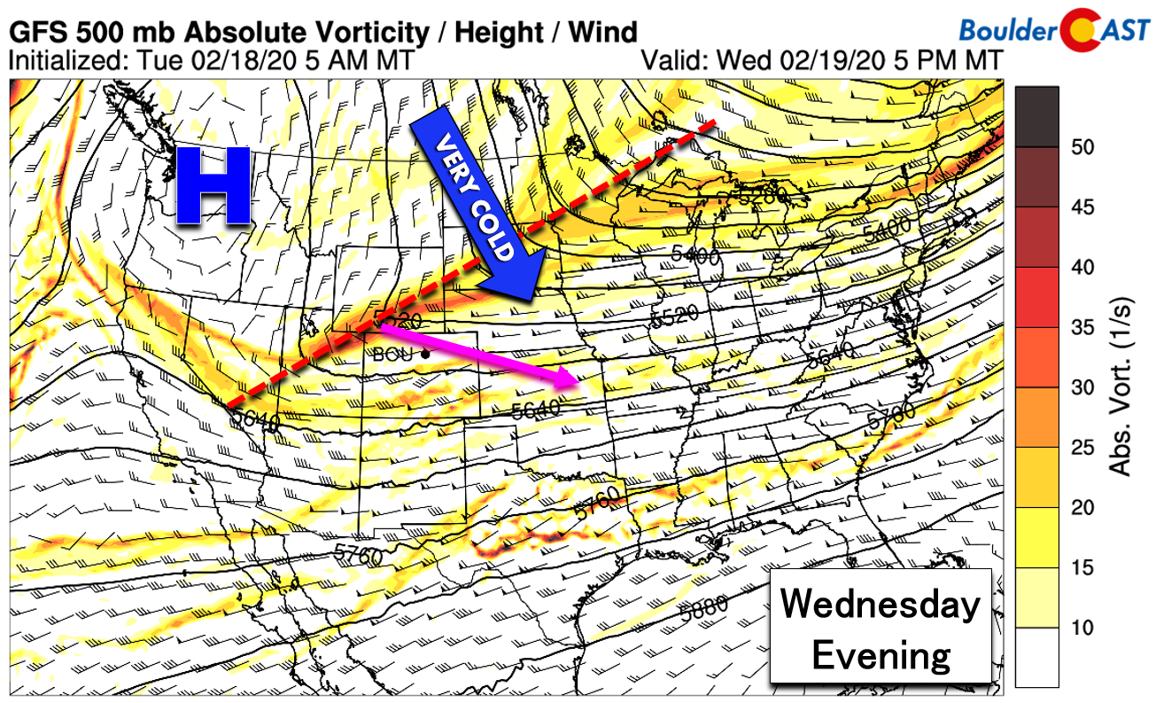
GFS 500mb vorticity map for Wednesday evening
As a consequence of the extreme tilt and trailing amplified ridge of high pressure (see above), the surface cold front will arrive well before the upper-level jet, moisture, and lift from the trough do. This mismatch in timing could lead to a short period of freezing drizzle mixed with flurries before things fully change over to snow. The probability for freezing drizzle is definitely low. It’s unclear exactly how quickly the lower atmosphere will saturate over the Denver Metro area. The most likely window for any freezing drizzle and flurries would be from about mid-morning Wednesday into the afternoon. After this, we should see a shift to snow as colder air filters in and better large-scale lift arrives.

NAM 800mb temperature and wind forecast for Wednesday evening
The Front Range is really on the “outside looking in” for this storm system: the best moisture, upslope, and jet activity will be across southeast Colorado where Winter Weather Advisories are posted.

However, don’t completely write it off! There is still enough ingredients coming together for a 6-12 hour window of generally light precipitation in the Denver Metro area. Our hopes for this snow event rest on moist, deep and directionally favorable upslope. Models agree on a clear northeasterly component to the wind fields over the Boulder/Denver area at both the near-surface and 10,000 foot elevation levels. With upslope efficiency decreasing with altitude, this is just the type of storm that can produce slightly larger totals at the base of the Foothills (in Boulder) than within the Foothills themselves.
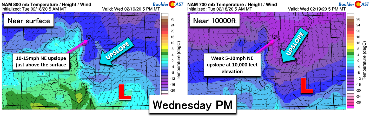
NAM forecast temperatures and winds at the near-surface level (left) and at 10,000 feet elevation (right for Wednesday PM
Timing
Wednesday will be cold and gloomy with temperatures in the 20’s through the day. Isolated freezing drizzle and flurries will be possible from mid-morning into the afternoon. Light snow will fully overspread the Front Range by late afternoon and will continue into the evening and overnight hours. A cold day with possible morning flurries is on tap for Thursday with highs in the middle 30’s.
.
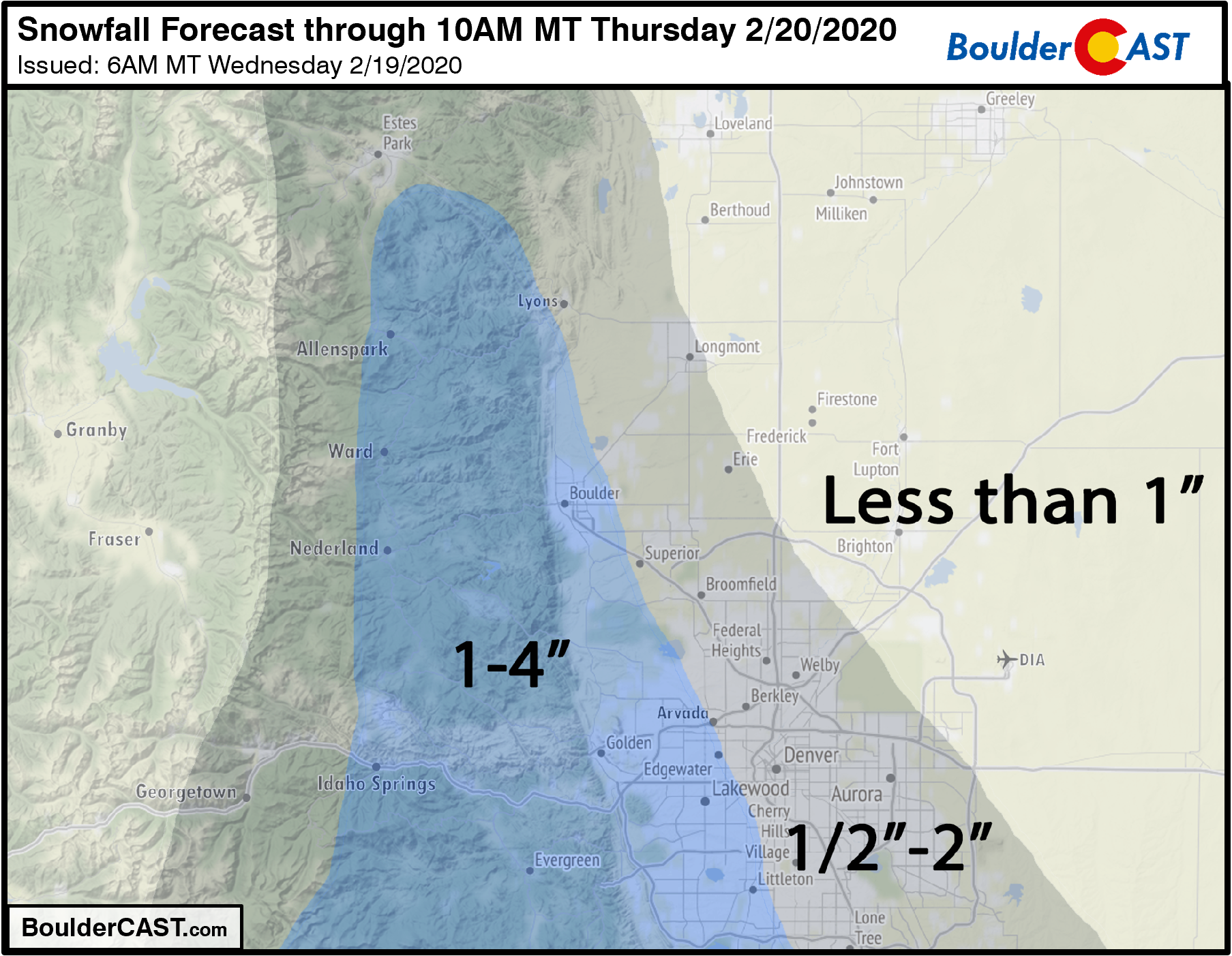
Snow Amounts
We’re expecting only light snow amounts from this event. The GFS is currently the snowiest of the weather models, producing 2 to 5″ in the Metro area area, with its ensembles closely clustered in support as well (see below). The Euro and NAM models show marginally lower totals, a hearty dusting up to 3″.

The upslope alone should produce a couple of inches in the far western and southwestern suburbs, including Boulder. Heading north and east away from the terrain, amounts will drop to nearly nothing around Denver International Airport, Brighton and Greeley. The late afternoon and early evening arrival of the snow and modest snowfall rates expected should lead to a relatively bearable evening commute on Wednesday, though areas west of Interstate 25 could be slick in spots. As the sun goes down in the sky and temperatures cool, roads will become slightly worse, but nothing too bad in the grand scheme of things.
Our snowfall forecast map for the event is shown below. This covers all snowfall through early Thursday morning.
When all is said and done, the potential outcomes for this weather event are fairly limited in our area: confidence is high that this will be just a quick shot of light snow. We’ll continue to monitor the situation and toss any necessary updates your way through the day. Until then, you know the drill: follow us on Facebook and Twitter, or even better help support our team of Front Range forecasters by joining BoulderCAST Premium. We talk Boulder and Denver weather every single day. Sign up now to get access to our daily forecast discussions each morning, complete six-day skiing and hiking forecasts powered by machine learning, first-class access to all our Colorado-centric high-resolution weather graphics, bonus storm updates and much more! Or not, we just appreciate your readership!

Subscribe to receive email notifications for BoulderCAST updates:
We respect your privacy. You can unsubscribe at any time.
.
Spread the word, share the BoulderCAST snow forecast!


You must be logged in to post a comment.