Following our second consecutive 70-degree day, Mother Nature has big changes in store for tonight. Less than a week after the last Front Range snow storm, another one is already knocking on our door. Unlike the previous event, the focus for heavy snow this time will be to the east of Denver, near the core of a rapidly intensifying surface low pressure. However, just about everyone should get in on the action. Read on for timing, amounts, and our thoughts on potential impacts.
UPDATE (Tuesday 10pm): Well, hate to update a forecast so late in the game, but the storm is coming together better and better with every model run. It is slowing down and shifting more to the west. That tight gradient in snow is moving with it. The major concern we had about downslope is all but gone at this point. In fact, upslope (even strong upslope) is now in play. The RAP (high-resolution short range model) is amazing. 30-40 knot northeasterly upslope at 700mb (below).

This actually is playing out very similar to the December 15, 2015 storm, where 11″ fell in Boulder out the of blue (seemingly) a bulk of which fell rapidly just before sunrise. Anyways, going to bump up our forecast at this point. Expecting heavy snow in the 4am to noon timeframe.
FORECAST: 5-12″ EVERYWHERE!
—
The weather system of interest is currently making its way across the Northern Rockies. The broad trough will move southeast and slide across Colorado during the day on Wednesday. As it does, the system rapidly intensifies into a closed-low over eastern Colorado and western Kansas. This transition can be seen in the four-panel time series below of 500 mb vorticity from the NAM.

NAM 500mb vorticity maps in sequence, showing the intensification of the low-pressure in Eastern Colorado by Wednesday afternoon
The intensification is especially evident in the bottom right panel, where the 500 mb low has a very tightly-wound core, a signature of a powerful storm!
The main issue (if your’re hoping for snow, that is) is that the intensification happens well east of Boulder. Near ground-level, under normal conditions, winds flow counter-clockwise around a low, slowly getting pulled towards the center. However, when storms undergo rapid development, winds become more ageostrophic, rushing to the center of the deepening low much faster. If the storm is well east of Denver, as is the case this time, this creates the perfect set-up for downslope across Boulder County.
This 700 mb relative humidity map for Wednesday morning at 6AM shows this effect nicely, with the core of the low along the KS/CO border, with strong northwesterly downslope over Boulder/Denver.
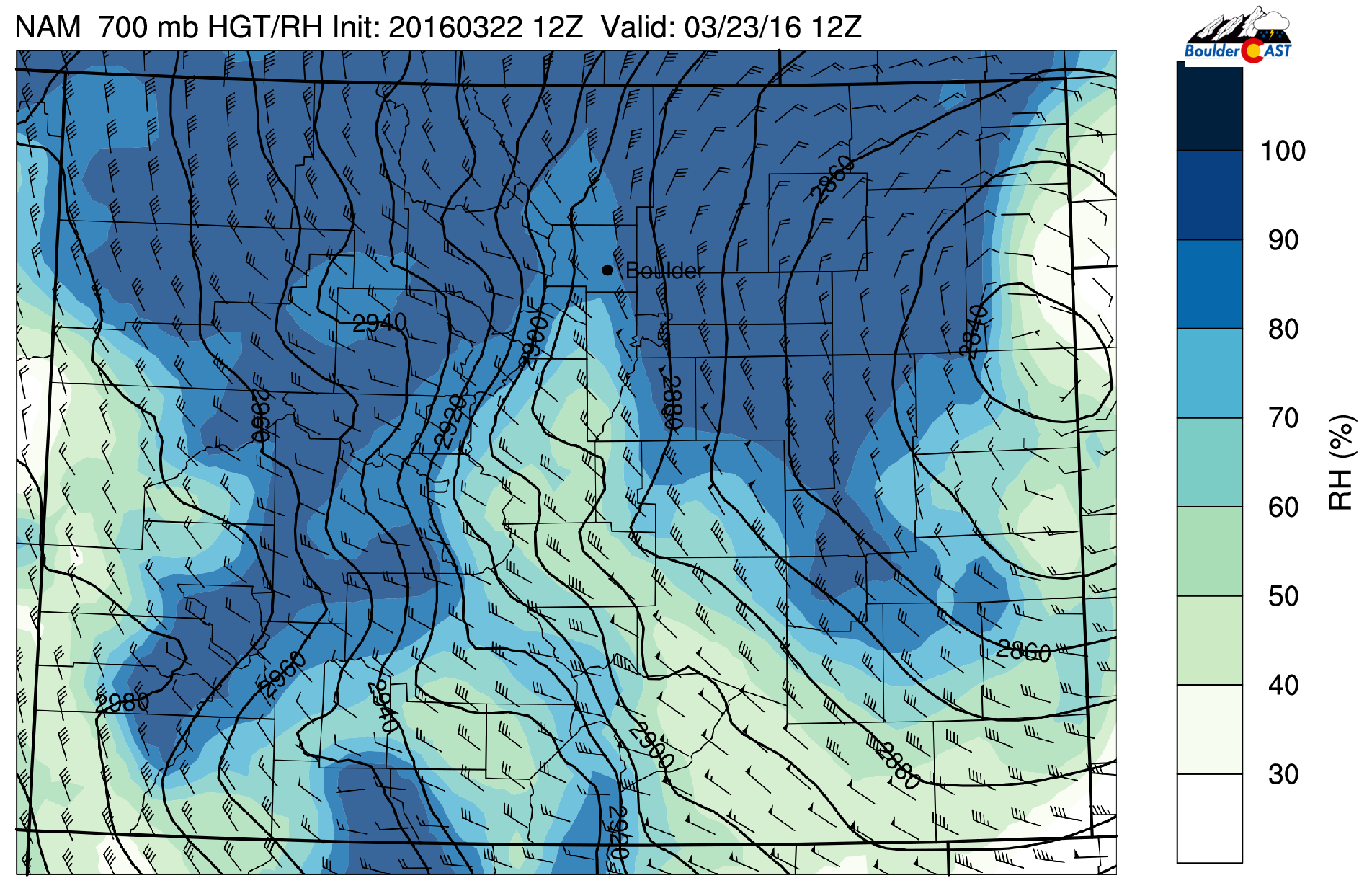
NAM 700mb RH and wind map valid at 6am Wednesday, showing strong NW downslope across Boulder County.
Despite the downslope, we don’t think we’ll be able to escape the snow entirely. There is a decent amount of large-scale lift and a ton of moisture available. However, the most significant snowfall will occur east of Denver, away from the bulk of the downslope and closer to the center of the low.
After highs in the 70’s today and a mild evening, a cold front will push through right after midnight tonight. There will be a chance of a few rain showers at the onset, before the coldest air arrives. The change over should be quick from north to south. Some flakes could be flying as early as 3AM tonight. It will be all snow in the Foothills and Mountains.
The best chance of snow in Boulder lies between 8AM and 2PM, when we get a slight shift in wind direction to N or even NNE. Temperatures will be marginal, between 32-36 degrees for the duration of the event. Even through the clouds, snow will have a tough time accumulating under the mid-day sun, except on grassy surfaces. Expect roads to be just wet, save in the heaviest bands (which will mostly be east of Denver).
We’ll also be experiencing some wind with this storm, even in Boulder, gusting in excess of 35 mph. With the warmer, wet snow, true blizzard conditions will be hard to come by, though if it happens anywhere, it will be east of Denver.
Snow will come to a close for everyone by late afternoon or early evening as the system pulls away and downslope reigns.
At this point, there are still some slight model discrepancies (isn’t there always?). Here are the forecast precipitation amounts from the GFS (left) and NAM (right).

Total accumulated precipitation from the GFS (left) and NAM (right). Less in Boulder, more from Denver east.
One thing is clear — the sharp gradient across Denver. Heavy to the east, light to the west. Both the GFS and NAM are showing 0.5″+ of liquid in the eastern suburbs of Denver, with more further north and east. The intensity of the NAM is likely overdone, but the shape looks good to us. Someone out in the prairie will get close to a foot, but it won’t be Denver.
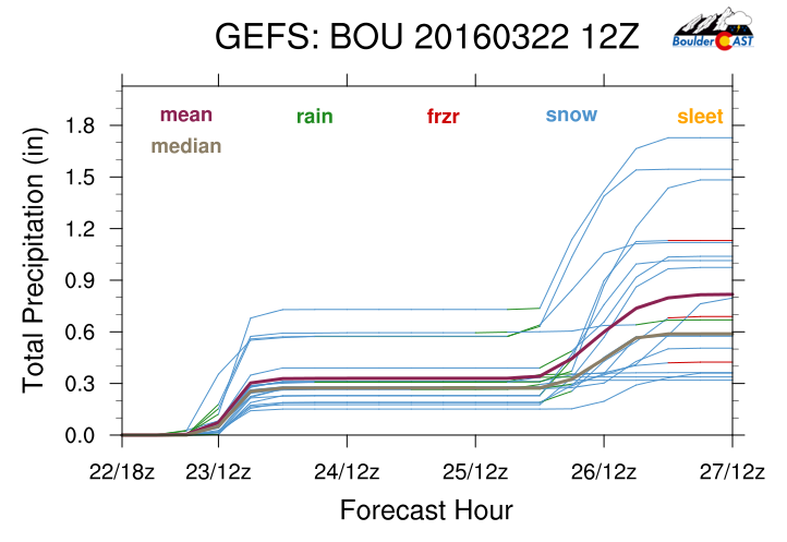
The latest GFS ensembles show ~1/4″ of liquid.
Overall, not a majorly impactful event across the area. At it’s worst, late morning and early afternoon tomorrow, travel through DIA could be impacted, but probably not substantially.
IN SUMMARY:
- A cold front moves in after midnight tonight, with scattered rain showers changing to snow before sunrise
- The best chance and heaviest snow will remain east of Denver, as Boulder County and much of the western suburbs will get downsloped
- Snow could be heavy at times from Denver east, with winds gusting up to 45 mph. There is a Blizzard Warning already in effect!
- There will be a sharp gradient in snow across the Metro area
- Snow wraps up Wednesday early evening, probably even earlier in Boulder
- Most accumulation will be confined to grassy surfaces, so roads should be mostly passable
As such, this is mostly a 4-8″ event for areas east of Denver, 3-6″ in Denver, and 2-5″ for the Foothills and western suburbs, including Boulder. Wednesday will be an okay ski day, with 5-10″ for many of the resorts tonight and tomorrow. Our forecast map is shown below.

Not to get ahead of ourselves, but we’re also tracking another potential snow event for Friday night into Saturday. In recent model runs, it has looked less impressive, at least for northeast Colorado. We’ll be sure to keep you updated. Have a good hump day!


and yet somehow I have a foot and counting in Louisville 😉
We think everyone enjoys more snow than expected! :O