The weather pattern over the next several days is relatively zonal. However, embedded quick-moving shortwaves will keep things interesting until the arrival of our next major storm system on Tuesday.
Today:
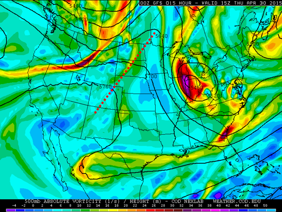
With a shortwave ridge (shown above) currently overhead and southwesterly low-level winds, overnight lows today dipped only into the low to mid 50’s on the Plains. Several cities came dangerously close to breaking the record for warmest low temperature for the date! It is not even 10am and temperatures are already in the low 70’s. With this flow pattern and abundant sunshine early on, we may reach close to 80 degrees this afternoon before clouds and storms develop ahead of a weak cold front moving south towards NE Colorado. Scattered storms will first fire over the Mountains and Foothills after noon, quickly spreading eastward onto the Plains. The GFS and NAM models both show the cold front, which is currently located in SE Wyoming, moving through Boulder later this evening, between 6 and 9pm. This will bring some weak upslope to Boulder County, which will help to enhance the daytime convective precipitation, at least initially. A nugget of upper-level energy will be moving overhead during this timeframe as well. Our best shot are precipitation is between 3pm and 11pm, after which the energy slides off to the east of Boulder County.
Surface map showing the location of the front, in SE Wyoming, evident from the wind shifts, located along a line from Cheyenne to western South Dakota.
Tomorrow:
Low-level upslope flow will linger into the day Friday to keep our temperatures on the cool side, with a potential fog/mist situation setting up in the Foothills and nearby plains early in the morning. However, with a mix of clouds and sun later on, we should still make it into the mid to upper 60’s on the Plains, with 50s and low 60s in the higher elevations. Storms will once again develop in the High Country, spreading eastward in the afternoon.
The Weekend:
Saturday will see a warm-up close to 80 degrees again, and decreased storm chances with a shortwave ridge passing through Colorado. Precipitation should definitely be more isolated on Saturday with sunnier skies. Sunday will feature the passage of yet another small-scale trough and an increase in afternoon storm coverage for our region. Temperatures Sunday will be similar to Saturday, maybe a couple degrees cooler. Snow levels through the period will be quite high, above 12,000 feet at all times, so don’t expect any significant accumulating snow anywhere in Boulder County.
Our next large scale system is on track to reach Colorado on Tuesday or Wednesday. Check back for updates as it approaches!


