With winter now officially under way (you didn’t miss the solstice did you?), the weather turns cooler and snowier right in time for the holiday. We provide an updated outlook through the extended weekend. Will any of us see a white Christmas this year? Read on to find out!
Heavy Snow in High Country
We’ll start by recapping the heavy mountain snow that has been ongoing the last several days across much of Colorado’s mountains. We warned in our post on Monday that locations in central and western Colorado were in store for 1 to 2 feet of snow by mid-week, compliments of moist westerly flow and a few embedded disturbances.
Snow totals thus far did not disappoint! Here are a few from around the area (72-hour totals, ending Wednesday 6am MT):
- Steamboat: 29″
- Loveland: 20″
- Breck: 19″
- Winter Park: 18″
- Vail: 18″
- Aspen: 17″
- A-Basin: 15″
- Copper: 13″
- Eldora: 11″
While these numbers are impressive, they are dwarfed by the nearly four feet recorded at some resorts in southwestern Colorado!
On the Plains, the last few days have been rather pleasant. A series of weak disturbances moved through, with a few quick shots of snow. Most areas got just a dusting (we measured 0.3″ at BoulderCAST station), but a few isolated locales picked up an inch or two in the heavier bands.
White Christmas?
In general, there are two acceptable meteorological definitions for the occurrence of a “White Christmas.” There must either be 1″ of snow present on the ground at any point during the day (which is the “official” definition as denoted by the NCDC), or 0.1″ of snow must fall and accumulate on Christmas Day. Surely we all prefer the second option, with actual snow flying as you open your gifts. Old, disgusting brown snow on the ground doesn’t really tend to spread the holiday cheer.
In a recent podcast, we discussed Boulder’s “White Christmas” climatology. When just considering the last 15 years, Boulder has a 33% chance of recording snowfall on Christmas day, but a 60% chance of having some snow on the ground. The longer term averages for Denver (14% snowfall / 38% snow on ground) suggest we have been relatively more fortunate since the turn of the century!
The map below paints the Front Range above 40%, with near 100% odds in the western Mountains.
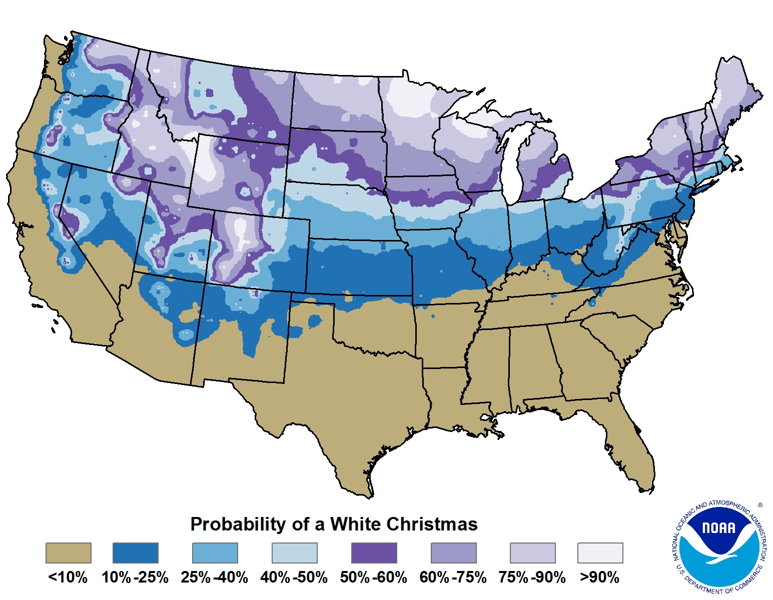
Percentage chance of having snowfall a White Christmas with 1″ of snow on the ground (Credit: NOAA)
In Boulder, and across almost all of the Front Range, the first “White Christmas” condition will be met, technically guaranteeing us a White Christmas this year! As of 6 pm this evening, Boulder officially rests at a snow depth of 2″. With temperatures likely to only reach to near freezing tomorrow (Christmas Eve), little additional melting will occur.
As far as the ladder condition, it looks probable to be met as well. A large, upper-level trough approaches Colorado from the northwest (shown below in the 500 mb vorticity map).
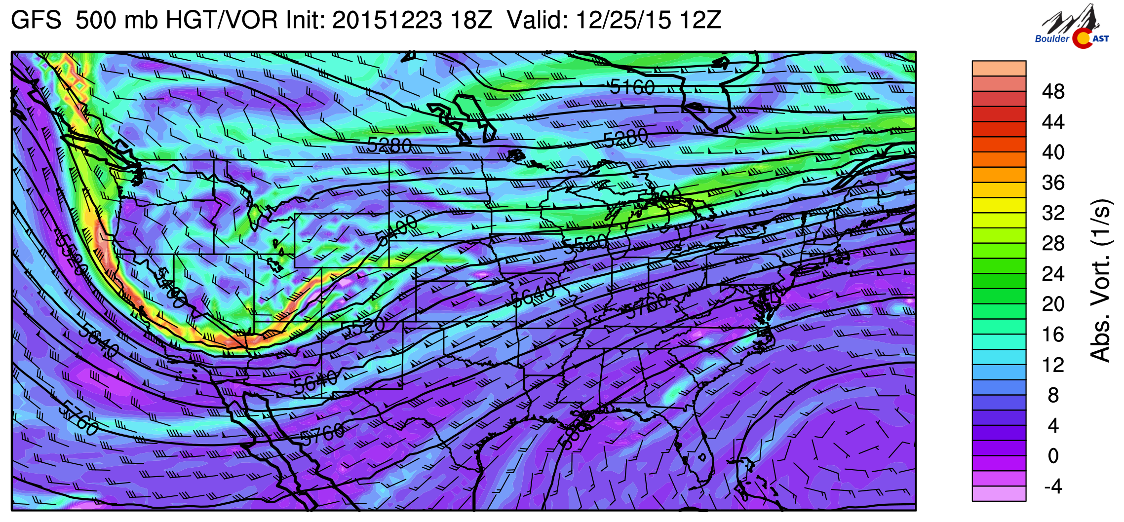
GFS 500mb vorticity map for Christmas morning
Models have the system splitting into two pieces. Unfortunately (if you like snow), the first piece splits off, just briefly clipping our region as it passes to our north. The secondary, more potent piece dives way to the south of Colorado into northern Mexico. That upper-low is shaping up to bring significant snow to New Mexico and west Texas come Sunday. The two, distinct pieces of energy are seen below.
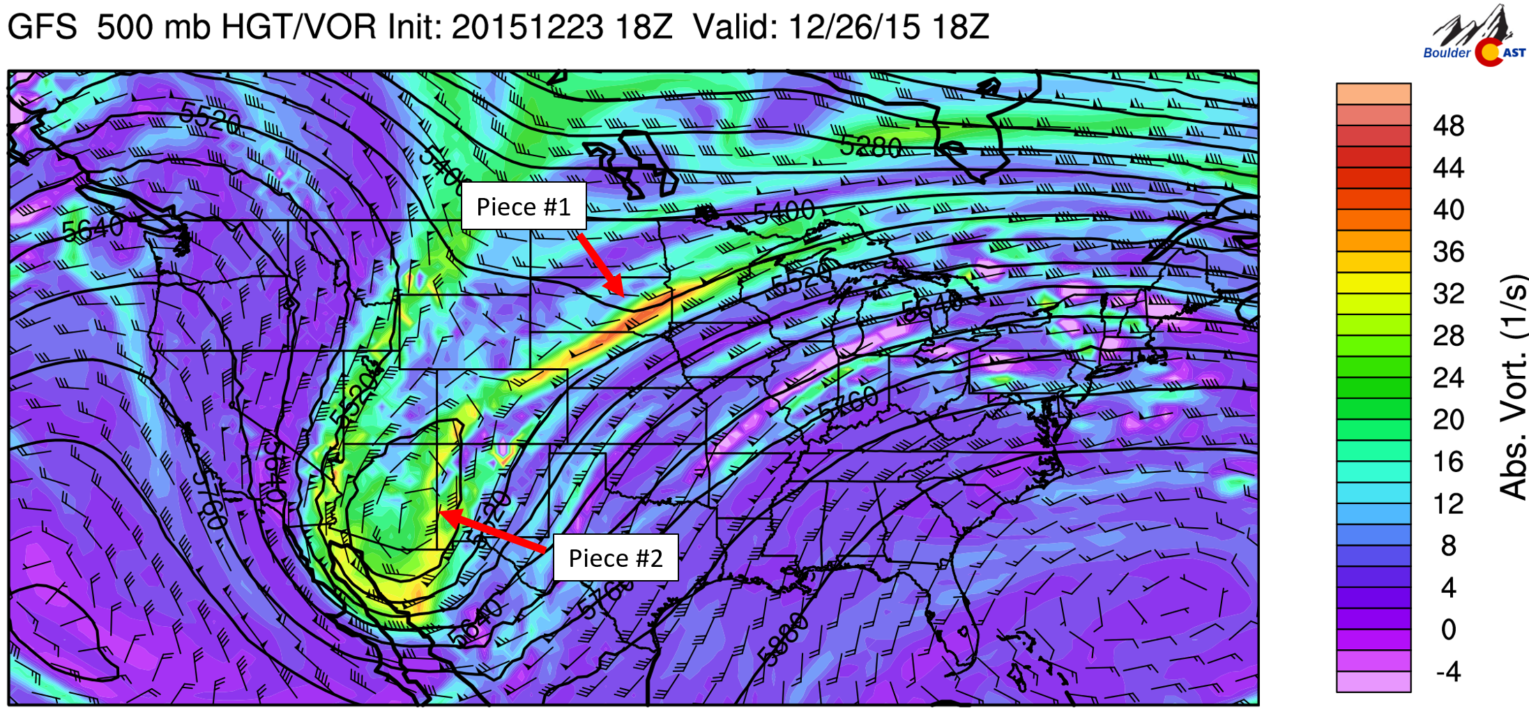
GFS 500mb vorticity map, valid Saturday afternoon. Notice how Colorado lies between the two pieces of energy
This situation doesn’t put the Plains in a particularly favorable location to pick up that much snow. However, as mentioned, the northern piece will skirt the Metro Area late Christmas afternoon and evening. A nearby jet and extremely weak synoptic lift may fire off a few widely scattered snow bands Christmas morning. In the late afternoon, a cold front slides into northeast Colorado, bringing much cooler temperatures and some light upslope.
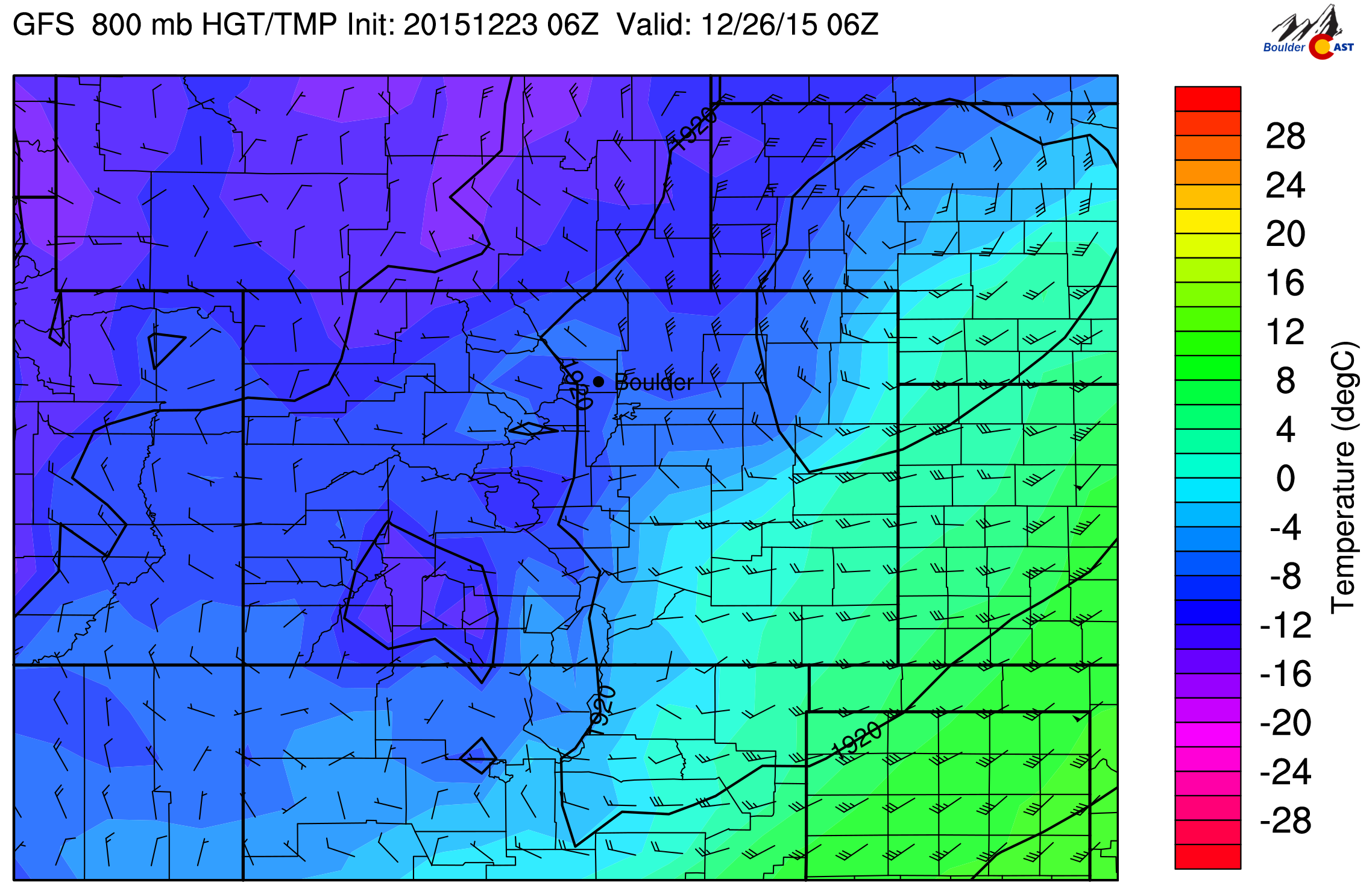
800 mb temperature map showing the cold front moving through Christmas evening
This will bring scattered snow showers to the area. The GFS begins the snow earlier, while the NAM is a bit delayed, making for more of an overnight snow event into Saturday. We will hedge towards the GFS for now, as it has been consistent. We think the best chance for snow will be between 4pm and midnight Christmas Day, though light snow is possible beforehand and may linger afterwards into Saturday morning.
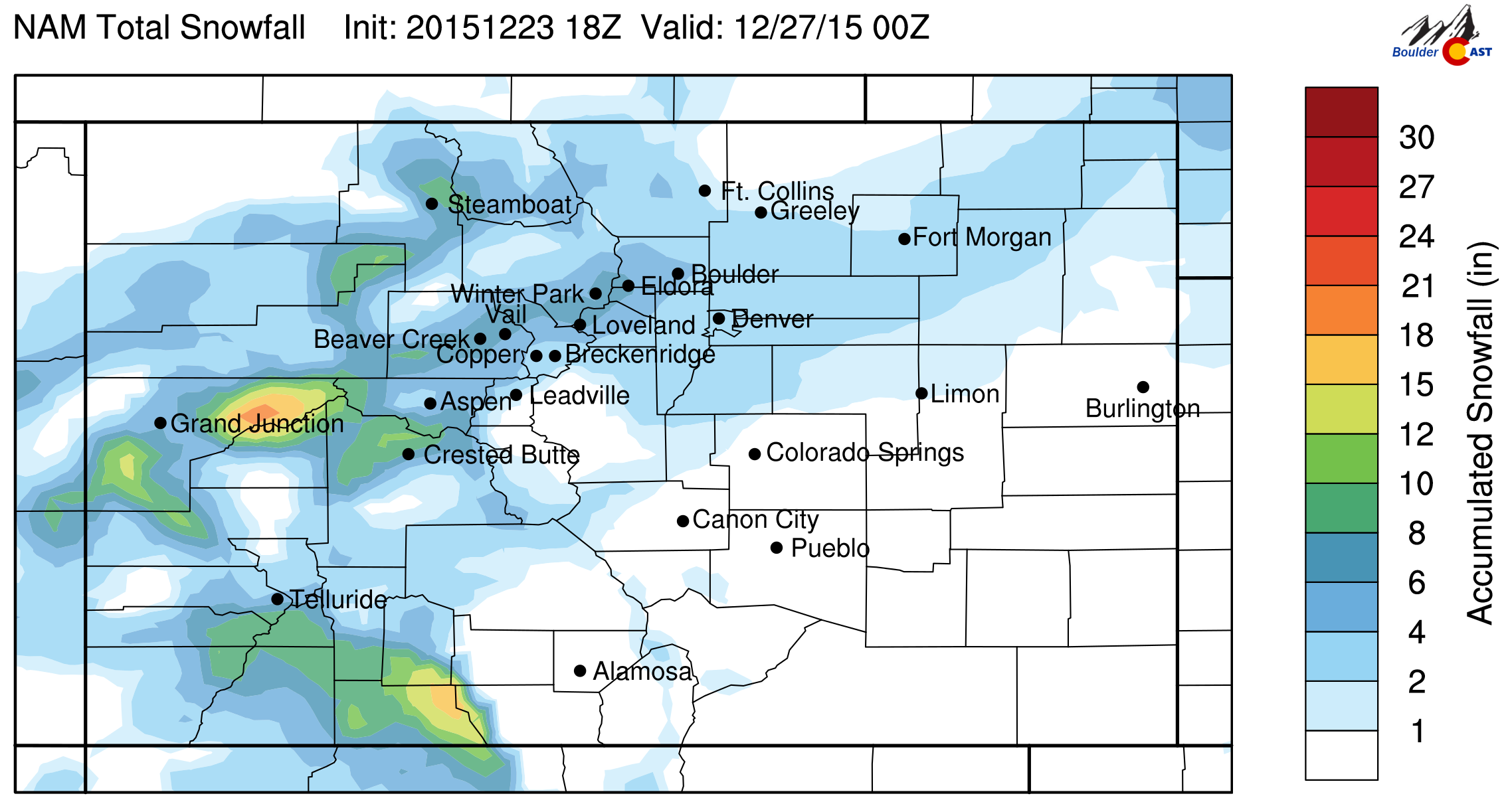
Snow accumulations will be on the light side, but given the occasion, anything is better than nothing! Likely 1-4″ for the Plains and a little more for the Foothills, with 6″ a safe bet for the Mountains (which will have snow beginning early morning on Christmas). The latest NAM run shows widespread snow accumulation across the area.
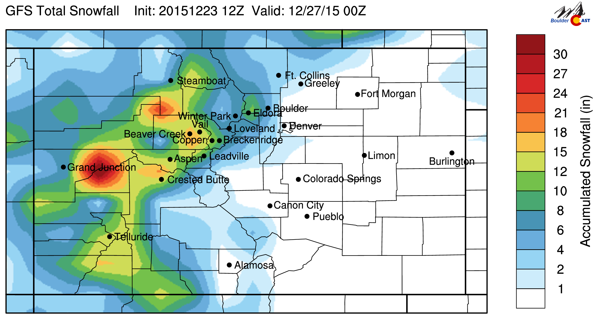
It does seem a little high to us, as we expect the highest totals to cluster towards the Wyoming border. The Euro is similar to the NAM, while the Canadian and GFS (shown below) produce a little less.
We summarize our current thoughts in this preliminary snowfall map:
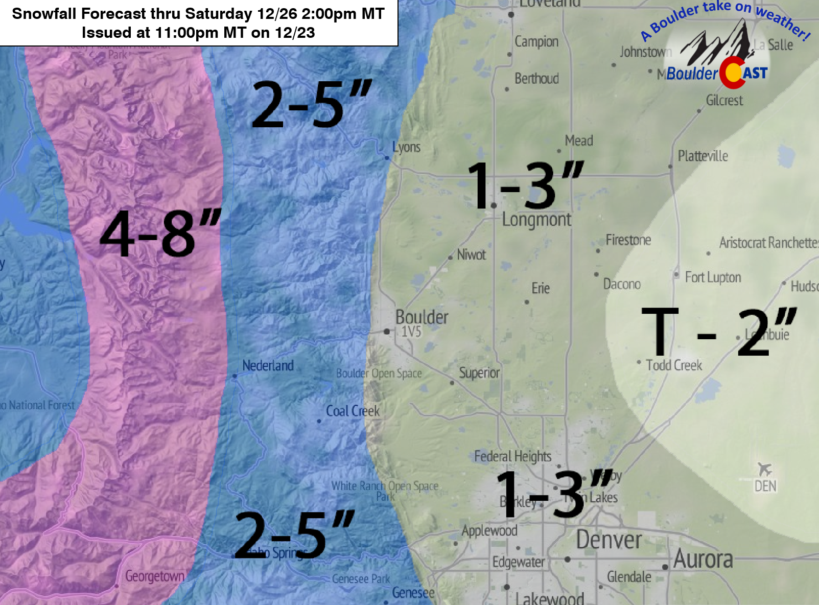
If we feel any tweaks are needed, we will post a short update late tomorrow evening. Be sure to check back then.
If you are up above 9,000 feet or located anywhere west of the Divide, curled up by the fireplace, not even able to open your front door with all the snow, you may find our intricate conversation of a few meager inches of snow and the meteorological technicalities of a “White Christmas” a little bit comical, or even desperate, but we take what we can get at the lower elevations!
Post-snow, temperatures on Saturday will remain very cold, only in the teens. If skies can clear Saturday night, some spots on the Plains could be flirting with below-zero temperatures Sunday morning for the first time this winter. Things dry out and temperatures moderate as we move into early next week.
Enjoy the holiday and have a safe and very Merry Christmas! Stay warm if you can!


