A potent but fast-moving winter storm is on track to arrive tonight, bringing accumulating snow, near-blizzard conditions, and much colder temperatures to Boulder County. Read on as we detail the precise timing and forecasted snow totals for the region (spoiler: Wednesday morning’s commute looks ugly!).
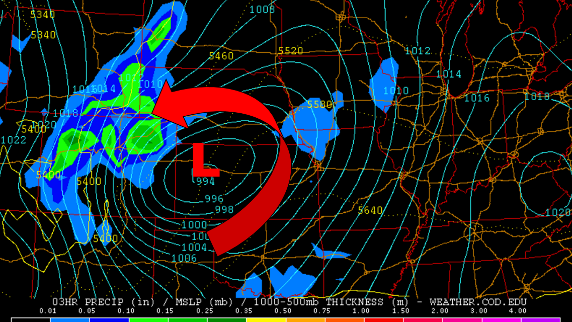
As we outlined in our forecast for this week, we expected a deep upper-level trough (and associated jet streak) to aid in the development of a strong, wintry low pressure in eastern Colorado. That has come to fruition.
Timing:
Today will start off sunny, but the sky will fill with clouds through the day. The surface low will begin its development this afternoon, quickly deepening into a tightly-wound, sub-990 mb system. Snow showers will begin in the High County by mid-afternoon. The Plains should remain dry until the storm really starts going later tonight, but an isolated light rain shower isn’t out of the question this evening.
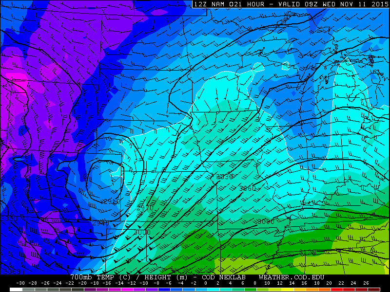
NAM forecast for 2am tonight showing a closed 700mb low over eastern Colorado. 20-30mph upslope winds are in place across the region, with 700mb temps near -5 degrees C. Remember, Boulder needs to be colder than -2 degrees C at 700 to support snow.
The models continue to agree remarkably well on how this event will play out. After topping out near 60 degrees this afternoon, temperatures in Boulder will fall through the 40’s after sunset, and into the mid 30’s by midnight. We expect precipitation to increase in coverage and intensity between 9pm and midnight this evening . It will begin as rain for the lower elevations, but snow levels will be falling from near 10,000 feet this afternoon, all the way down to the Plains sometime at or slightly before the clock strikes twelve.
Wind:
A rapidly intensifying storm will drive strong winds late this evening and overnight. The strongest winds will remain to our east, closer to the center of the low, where Blizzard Warnings are in effect (look at all that red below!).
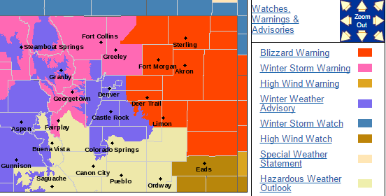
In Boulder County, a Winter Storm Warning is in effect for the Foothills and Mountains, while the Plains are currently sporting a Winter Weather Advisory.
However, during the height of the event, we may see winds in the 15 – 25 mph range, with gusts up to 40 mph, especially in the Foothills. As such, drifting and blowing snow may make for hazardous driving overnight and for the morning rush hour, despite not officially meeting blizzard criteria.
Snow Totals:
The fast-moving nature of the system will greatly limit our overall accumulation. The best upslope and dynamics for Boulder County will occur between midnight and 6am, so expect the heaviest snow during this time-frame. As the low pulls away into Kansas tomorrow morning, upslope will be replaced with strong downslope winds, bringing a rapid end to the precipitation and clearing skies. Snow showers should taper off before 11am. With the sun, temperatures will rebound back into the 40’s, melting a significant portion of our fresh snow by sunset tomorrow evening!
Shown below is the latest GEFS ensemble plume for precipitation in Boulder. Notice how there is two distinct clusters: one near 0.3″, and another higher around 0.6″. We suspect some of the ensembles are latching onto the downslope potential for this system, reducing snow accumulations for the region adjacent to the Front Range Mountains.
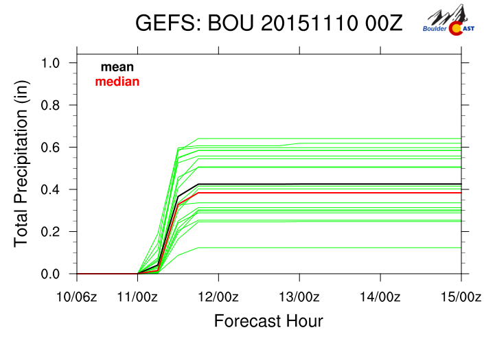
We also need to take into consideration that the ground is very warm, and temperatures will only bottom out tonight near 30 degrees in the city. Assuming a snow to liquid ratio of 8 to 1, the models are suggesting 2 -4″ for Boulder. There will be less melting, colder temperatures and better orographics higher up, so as usual, you can expect more snow there.
When it is all said and done, snow totals for the area should look like this:
- Plains: 2 – 5 “
- Foothills: 3 – 7 “
- Mountains: 5 – 12 “
NOTE: Though this snow will be heavy and wet, and a sizable portion of our trees are still rocking their leaves (on the Plains), we do not expect any widespread power outages since snow totals are rather modest.
Don’t let the beautiful and warm weather this afternoon get your guard down. Tomorrow’s AM commute will be slick and downright dangerous. Be sure to stay tuned to BoulderCAST on Facebook and Twitter through the duration of the event!


You must be logged in to post a comment.