After a tranquil weekend, the weather pattern turns more active again with our next shot of snowfall this evening into tomorrow morning. This is all thanks to another potent low pressure system coming out of the Eastern Pacific Ocean. How much will we get? What will the rest of the week feature? Read on to find out more details!
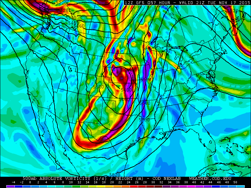
Our forecast today focuses on a large trough of low pressure pushing into southern Colorado today and tonight. The closed-off, mid-level storm is currently located over southwest Colorado (shown below).
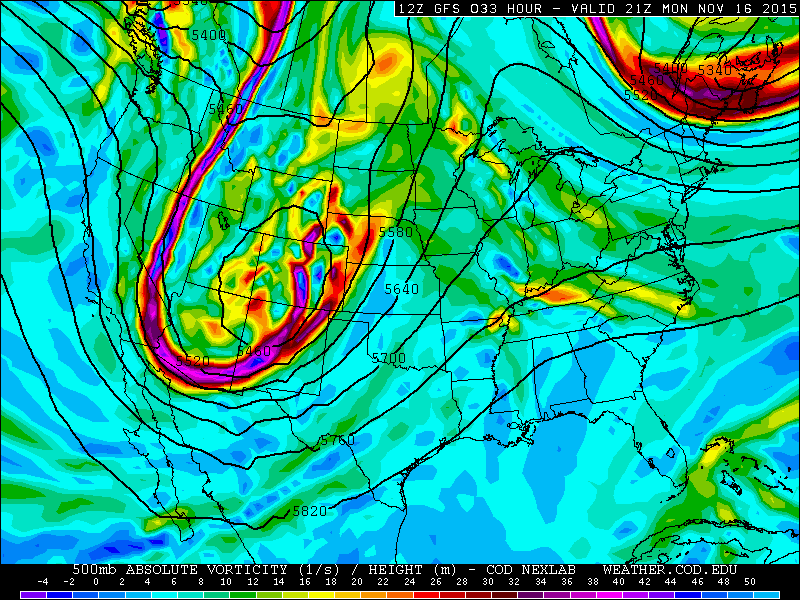
500 mb absolute vorticity for Monday from the GFS
Over the weekend and late last week, forecast models were highly uncertain as to the exact track and speed of this storm system and therefore the impacts it would have across Boulder County. A few models forecasted the system to stall over the area for several days, dropping feet of snow, not inches. That facet all but disappeared from the models on Saturday, but late Sunday night into this morning, models are once again hinting that this storm could drop a fair amount of snow for us.
As of this post, models are in much better agreement, with the GFS, ECMWF, and WRF showing that the storm will track from southwestern Colorado into Kansas by Tuesday, and then to the upper Midwest by Wednesday (it won’t stall). The track of the system is just a little bit too far south and it will be quick-moving (exiting Colorado by mid-day Tuesday). Neither of these facets bode well for a significant winter storm across Boulder. However, things look a little better today than they did just 24 hours ago. A few things are certain:
- Temperatures are cold enough in that we should see all snow, with the exception of the very onset of the event this afternoon, where isolated rain showers will be possible
- Overall, temperatures should be a few degrees colder than with last week’s storm, so expect the snow that does fall to stick a little better
- A decent snow event is likely for the High Country and adjacent Foothills, and from Denver south.
The greatest uncertainty lies in how much Boulder and the nearby Plains will actually accumulate.
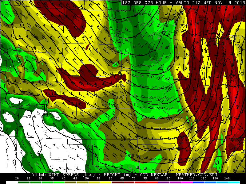
Below shows the 700 mb temperature and wind speed/directions from the GFS model for this evening. It shows the area of low pressure over eastern Colorado. Also of note is that temperatures are well below freezing, close to -6 degrees Celsius. You can also see northeasterly upslope winds over northeast Colorado.
The storm will be moving somewhat quickly, and therefore, the upslope flow will only be present for about eight or so hours. Winds will sharply turn more north-northwesterly before sunrise Tuesday morning, resulting in downslope flow, which inhibits precipitation for most of Boulder County, especially the city.
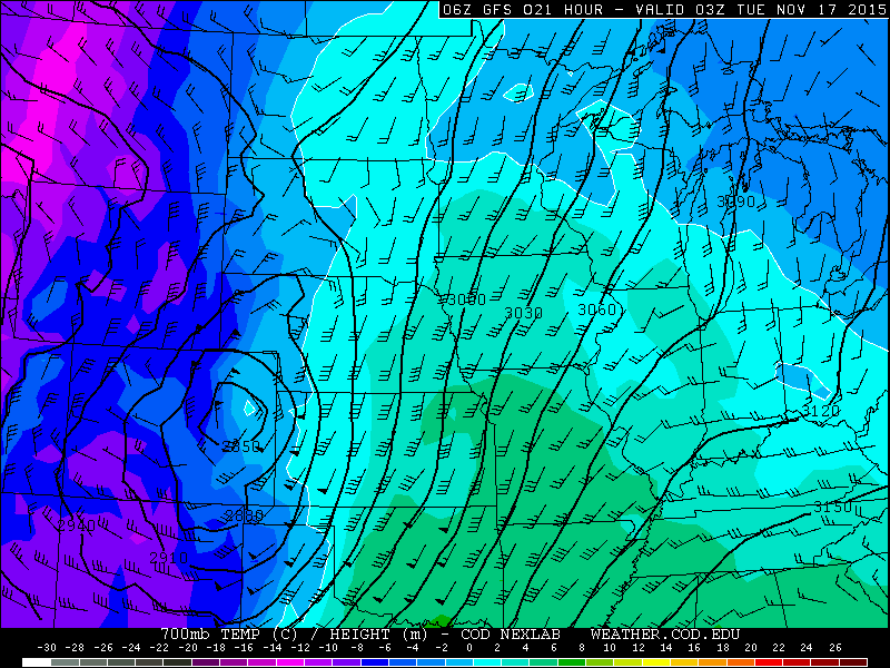
700mb temperature and winds from the GFS, valid Monday night at 11pm.
So how much snow and when will it start? Outside of a few light rain showers by mid-afternoon, expect snow to commence between 5 and 8pm. The time period of heaviest snow will be late this evening until about 5am tonight. Snow amounts are still rather uncertain.
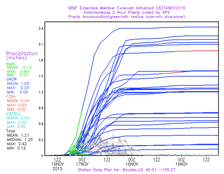
As you can see below, the Short Range Ensembles Forecast (an ensemble model which consists of 20+ individual forecasts from various sources), shows that even this close to the onset of the event, there is a HUGE amount of uncertainty as to the exact amount of total precipitation for Boulder. Some forecasts show over a foot of snow, while others show as little as 1″. The mean and median, however, show around 12″ of snowfall.
Similarly, the GEFS (Global Ensemble Forecast System) has mean values near a foot as well.

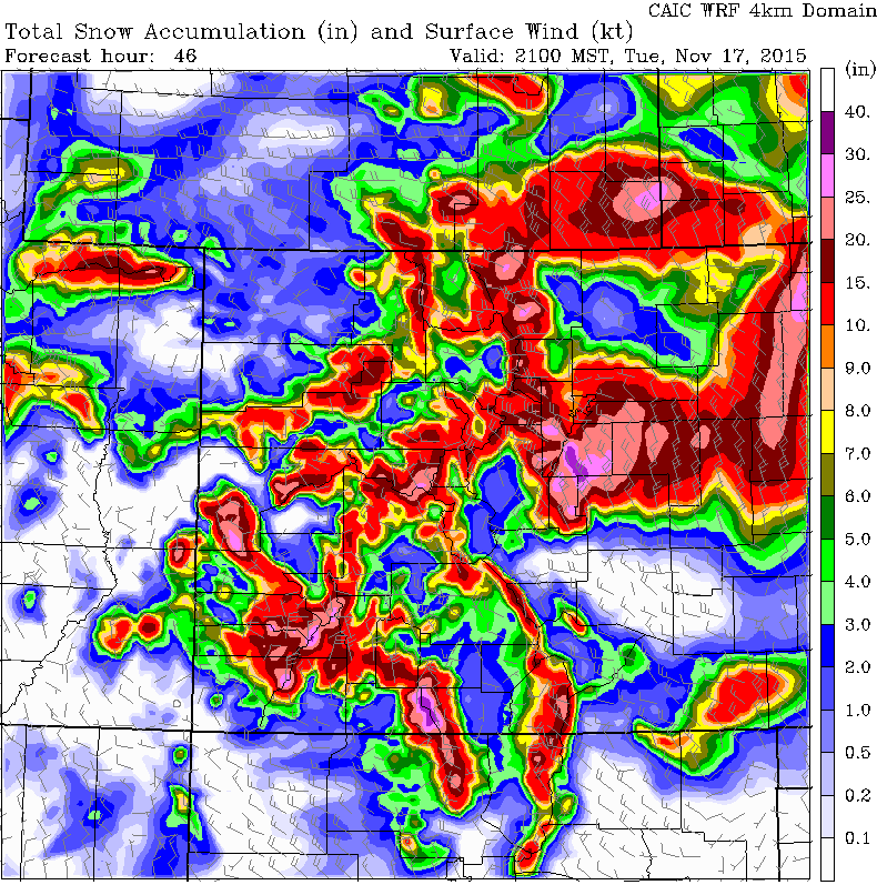
The high-resolution WRF model’s forecast snowfall is (what we believe) more realistic for Boulder, with a huge bulls-eye of lower snow totals from Boulder, northward towards Fort Collins and Greeley. The Mountains and Foothills do much better. The largest threat for “major snow” is in the areas east and south of Denver, where snow totals exceeding one foot will be possible. Blizzard Warnings are in effect for those regions (including downtown Denver).
Given the above discussion and uncertainties, Boulder County can expect:
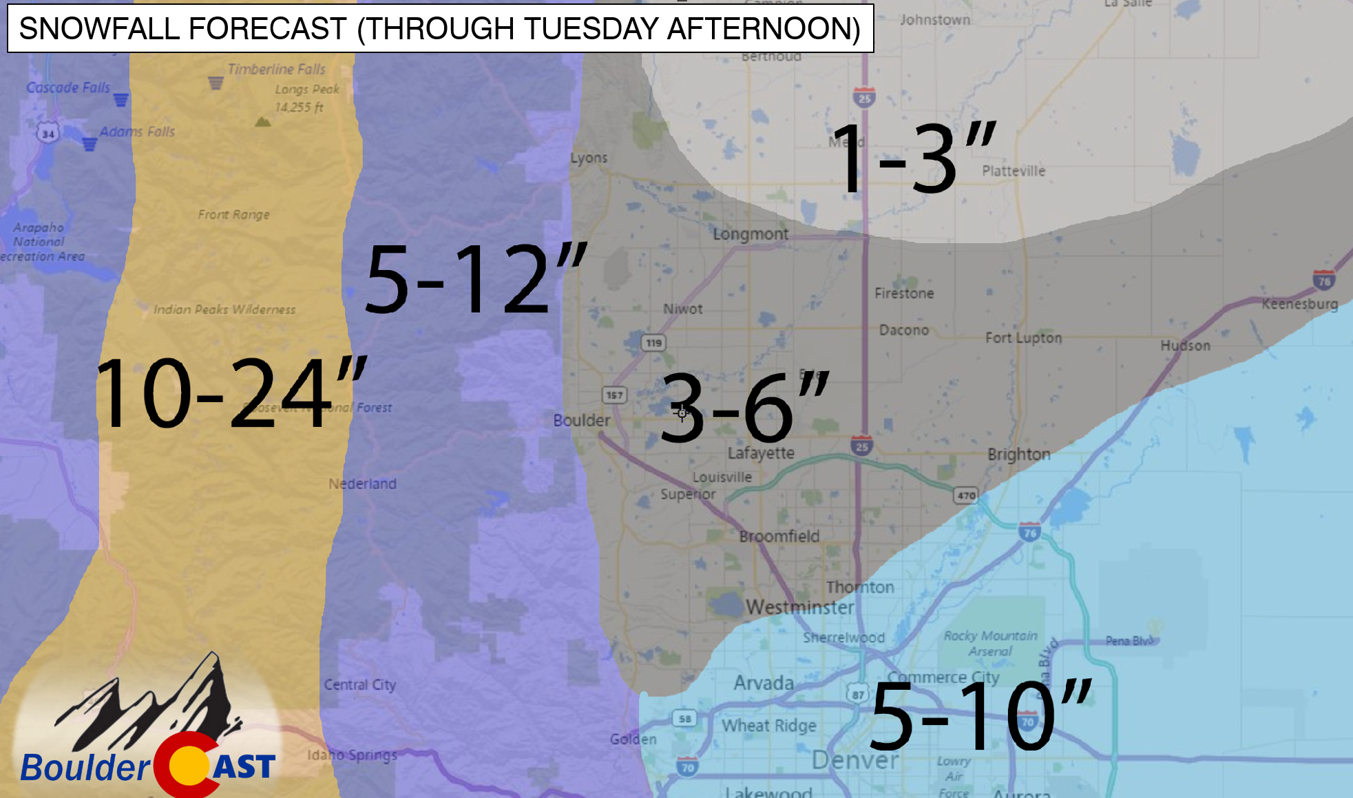
- Plains: 3 – 6″ (highest amounts to the east in Superior/Louisville area)
- Foothills: 5 – 12″
- Mountains: 10 – 20+”
- From Denver south: 6-14″
Despite the model consensus that Boulder could see near a foot of snow, the quick flip to downslope flow tonight for areas adjacent to the Foothills (like the city of Boulder) is the main reason for our expectation of lower snow totals (relative to Denver). There is still great uncertainty in how this snow storm will play out. We may need to issue an update later today if the snowier scenario becomes more likely.
The low moves off into Kansas by tomorrow afternoon. However, its influence will still be felt across region with gusty west-northwesterly winds up to 35 mph and temperatures in the low 40’s on the Plains. Snow showers will come to an end in the morning. In the Foothills, expect periods of snow showers to persist into the early afternoon before tapering off.
500 mb absolute vorticity for Tuesday from the GFS
As we go into Wednesday, the system is long gone. The upper-level jet stream will be overhead, which will lead to both warming temperatures and gusty Chinook winds (strong downslope winds which can greatly increase our temperatures). The 700 mb winds are 50 to 60 mph from the west. Although not a certainty, this pattern indicates a good chance of gusty strong winds during the day on Wednesday, with the prime time being morning to afternoon hours. It’s possible Boulder could see gusts over 45 mph Wednesday. This flow will warm us back into the middle 50’s on the Plains.
700 mb winds for Wednesday from the GFS model
By Thursday and Friday, the weather pattern relaxes and becomes more of a (calmer) west-northwesterly flow in the upper-levels of the atmosphere. With this pattern, cold intrusions will be the main story, bringing short-lived cooldowns to the region. The first intrusion of cold air builds in Thursday. This is evident in the below 700 mb temperature plot from the GFS. It shows a large amount of cold air from Canada sliding southward on Thursday. As a result, highs will be cooler than Wednesday with northeasterly surface winds. Temperatures will moderate a little on Friday, but still be on the chilly side.
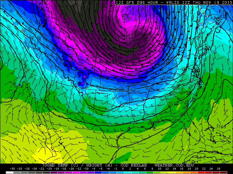
700 mb temperatures for Thursday from the GFS
The Forecast:
Monday: Mostly cloudy skies becoming overcast. A few light rain showers possible in the early afternoon, then snow likely after 5pm. Highs in the upper 40’s on the Plains and mid 40’s in the Foothills. The heaviest snow fill fall from 6pm to midnight. Snow totals of 3-6 inches in the city, with 5-12 inches possible in the Foothills.
Tuesday: Snow showers in the early morning, then partly sunny with a few scattered snow showers in the late morning and early afternoon, Highs in the low 40’s on the Plains, with mid 30’s in the Foothills. Little if any additional snow accumulation expected. Breezy northwest winds in the evening.
Wednesday: A mixture of clouds and sunshine. Northwest winds potentially gusting over 45 mph in the late morning and afternoon. Highs topping out in the mid 50’s on the Plains with upper 40’s in the Foothills.
Thursday: Mostly sunny and chilly. High temperatures in the upper 40’s on the Plains, with lower 40’s in the Foothills.
Friday: Partly sunny and seasonal. Highs in the lower 50’s on the Plains and middle 40’s in the Foothills.
Extended Outlook: Temperatures look to remain on the chilly side for the upcoming weekend. Some of the forecast models are hinting at another chance for snow as early as Saturday. Stay tuned.
High Country Forecast:
Snow showers will be present across much of the Mountains today and tomorrow, with 6 to 14 inches of accumulation by Tuesday evening. On Wednesday, snow showers will also be likely across northwestern Colorado and areas west of the Divide. Expect only light snow showers Thursday, but intensity to increase by the weekend.
Source
Mon
Tue
Wed
Thu
Fri


BoulderCAST
48
39
55
48
53


NWS
49
34
48
49
48


AccuWeather
49
39
51
48
51


The Weather Channel
45
42
50
48
52
Last week’s recap:
Here are the results of last week’s forecast. First, the forecasts and observations from all of the sources:
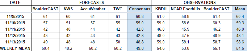
We were expecting a mild start to the week, cooling down as the snow-producing cold front arrived Tuesday evening. We expected 2-4″ of snow for Boulder. Officially, we got 1.7″, thanks to downslope warming that prevented much snow from sticking. We did pick up more than 0.5″ of liquid, however.
Let’s look at the error analysis. Shown below is the amount of degrees (in Fahrenheit) that each source was off from the mean observed temperature for Boulder. Positive values indicate the forecast was warmer than what actually occurred, while negative values arise from a forecast that was cooler than what was observed.
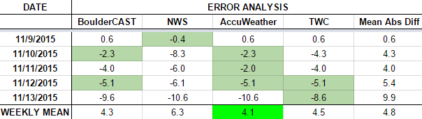
The worst forecast for the week ended up being Friday, with nearly 10 degrees of error averaged across the board. The atmosphere warmed back up, quite more than expected after the cooler air mass moved out. This allowed temperatures to soar to near 60 degrees (way above the forecasted 49).
The bottom row of the error table shows the weekly mean error for each weather outlet, a good measure for who was the best and more consistent “forecaster” for the week. AccuWeather takes first place this week, with a hefty 4.1 degrees of error. BoulderCAST fell just short, and takes second place, having the best forecast on Tuesday and Thursday. The NWS brings up the rear, making fairly bad forecasts every day but Monday.


You must be logged in to post a comment.