The recent trend of dry and mild weather will continue , with little in the way of interesting happenings this week. Read on to find out when we will have our next chance at snow.
The Plains have not recorded any precipitation over the past week, with just a few light snow showers having occurred over the highest elevations of Boulder County. This pattern is definitely a change from what we had been experiencing during the month of November, where one or two storms impacted us per week.
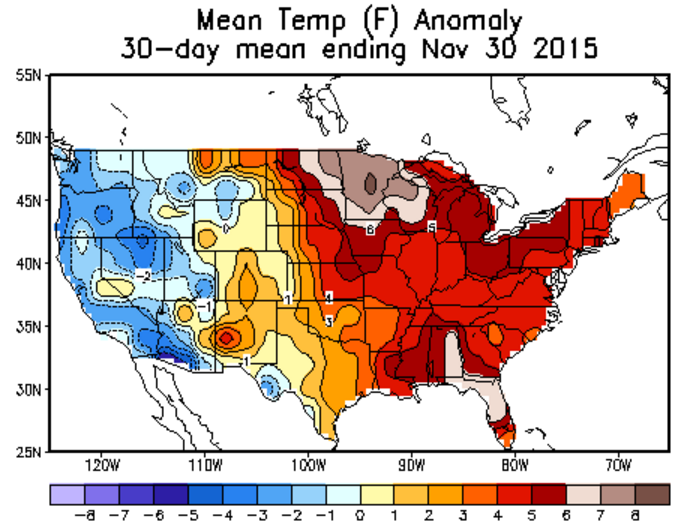
Speaking of which, Boulder ended November about as normal as possible for temperature (about 0.3 degrees above normal). For precipitation, we recorded 1.83″, which is more than 0.6″ above average. However, because of the few snow storms that remained as rain for the city, we concluded the month 3″ below normal in the snow category.
We have been and will remain under the influence of dry, zonal upper-level flow. The current 500 mb vorticity map is shown below.
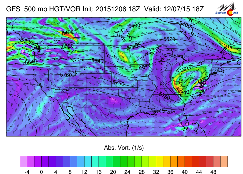
GFS 500mb vorticity map, valid at noon Monday
Notice the straight and near-westerly flow across the state of Colorado.
With this pattern, we normally expect dry, sunny weather across the Plains, and possibly snowy conditions in the Mountains (especially west of the Divide). However, the flow is just too dry, so not even the Mountains will see any precipitation!
The atmosphere remains in this docile state for many days. Here is the same map, but for Thursday morning. Not much change.
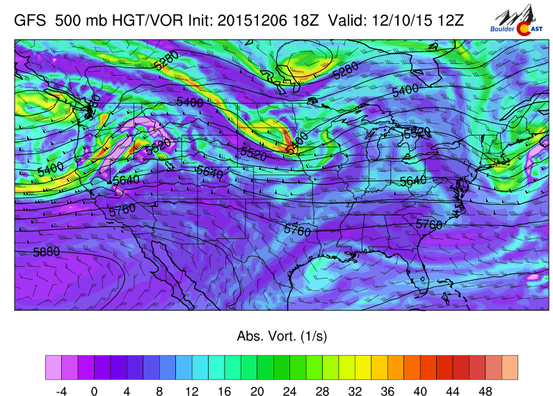
GFS 500mb vorticity map, valid Thursday morning
Admittedly, there is a bit of ridging across the Rockies (very slight!) by Wednesday and Thursday afternoon, as our next weather system finally makes an approach. The trough of low pressure can be seen nearly ashore in Seattle. Until it arrives, temperatures will remain very warm in the upper 50’s and 60’s for afternoon highs through the week (near record levels, but likely a couple degrees shy). Strong, gusty winds in the high terrain will be present most of the week (gusts above 60 mph in the Mountains, and above 40 mph in the Foothills and adjacent Plains), as well as various wave cloud signatures across the Plains.
The accumulated precipitation from the GFS through Thursday evening tells the story. .
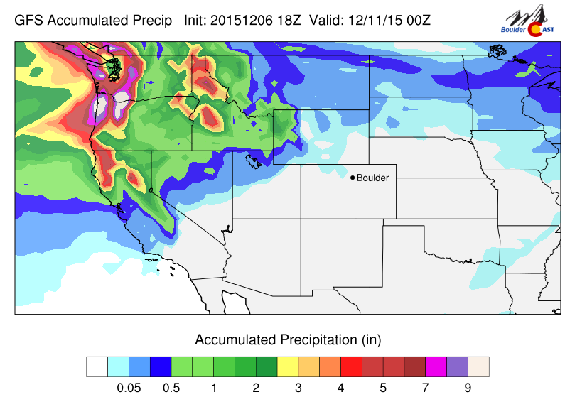
Total precipitation from the GFS through Thursday evening
This above map also depicts a much needed deluge of precipitation for the Pacific Northwest, with the coastal areas of Washington and Oregon in store for 5+” of rain, while the Cascades may see two to five feet of snow!
Back in our neck of the woods, ahead of the trough, we expect light snow to break out in the Mountains Thursday afternoon and continue into the weekend. Nothing major, just a couple of inches in the favored western slopes.
Friday morning, the trough arrives and the leading edge of the cold air will push southeastward, through the Foothills and onto the Plains. It won’t be anything too cold or abrupt, as the air mass is mostly maritime in origin, not polar. Temperatures on Friday will top out in the 40’s, gradually falling through the afternoon. Cloud cover will be more extensive, but we won’t commit to a gloomy day just yet, as there is essentially no low-level upslope. The models don’t want to spit out much precipitation with this event either. Any precipitation that does occur will likely be Friday evening into early Saturday morning and driven by weak synoptic lift and possibly the jet. At this point, it looks like less than 1″ of snow, likely just a few flurries. If things change, we will let you know!
UPDATE (Tuesday, December 8 6pm): The models have changed significantly in the last several runs, now looking promising for system moving in on Friday, developing a surface low across southeast Colorado Friday night into Saturday morning. As of now, the best energy stays south of Boulder. However, we could be looking at a several-inch snow event to end the week. Look for an update later in the week!
The Forecast:
Monday: Mostly sunny and mild. Breezy in the Foothills, with winds gusting to 45 mph. Highs near 60 on the Plains, with mid 50’s in the Foothills.
Tuesday: Partly to mostly cloudy and warm. Winds gusting to 50 mph, mostly in the Foothills. High temperatures in the low 60’s across the Plains, with upper 50’s in the Foothills.
Wednesday: Sunny and warm. Breezy in the Foothills, gusting up to 50 mph. Highs in the mid 60’s on the Plains, upper 50’s in the Foothills.
Thursday: Partly cloudy. Highs in the low 60’s for the Plains, with mid 50’s in the Foothills.
Friday: Mostly cloudy and cooler. A cold front arrives in the morning. Temperatures only in the upper 40’s for the Plains and Foothills, falling into the 30’s by evening. A chance of snow showers for both the Plains and Foothills, particularly Friday evening into Saturday morning.
Extended Outlook: Dry conditions will dominate the end of the weekend (except for some light snow in the Mountains near the Continental Divide). Early next week, the models hint at the arrival of another, potentially more impactful weather system in the Tuesday time frame. Stay tuned.
Source
Mon
Tue
Wed
Thu
Fri


BoulderCAST
58
60
64
61
48


NWS
58
61
64
63
44


AccuWeather
56
58
61
61
48


The Weather Channel
56
58
60
59
46
Last week’s recap:
Here are the results of last week’s forecast. First, the forecasts and observations from all of the sources:
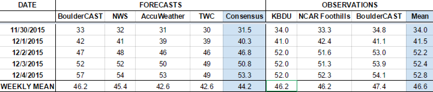
Last week began in the grasp of an Arctic air mass, but warmed up each and every day as downslope warming took over. We didn’t expect any precipitation for the Plains, and that was the case.
Let’s look at the error analysis. Shown below is the amount of degrees (in Fahrenheit) that each source was off from the mean observed temperature for Boulder. Positive values indicate the forecast was warmer than what actually occurred, while negative values arise from a forecast that was cooler than what was observed.
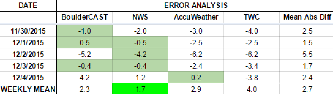
The worst forecast day of the week ended up being Wednesday, with more 5 degrees of error averaged across the board. Temperatures warmed to 52 degrees (above the forecast of 47). The magnitude of the warming from downslope is always a tricky forecast, especially with an Arctic air mass initially in place. Every other day of the week was forecast quite well.
The bottom row of the error table shows the weekly mean error for each weather outlet, a good measure for who was the best and more consistent “forecaster” for the week. The National Weather Service takes first place this period, with just 1.7 degrees of error. BoulderCAST fell just short, and takes second place, having the best forecast on Monday, Tuesday, and Thursday.


You must be logged in to post a comment.