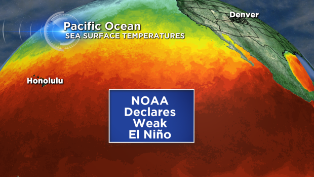
Last year around this time, the media was chirping about the possibility of a moderate El Niño developing by the end of 2014, a prediction which never fully came true. Now, climatologists are boldly making the same prognostication heading towards the upcoming winter season, with such descriptive words as “moderate” and “strong” once again being thrown into the mix. We explain exactly what El Niño is, how it can impact Colorado, and the forecast heading into next winter.
What is El Niño ?
Nowadays, El Niño is quite ubiquitous in our society. Everyone has heard of it, but few truly know what it entails and the impacts it can have on their local weather. In the most basic sense, El Niño is defined as the presence of anomalously warm water stretching across the Equatorial Pacific Ocean. It’s counterpart, called La Niña, is characterized by anomalously cold water in the same region. Because of the Pacific Ocean’s expansive size, the entire Earth’s atmospheric circulations are influenced by these temperature abnormalities. These alterations can actually have weather implications on a global scale!
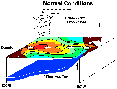
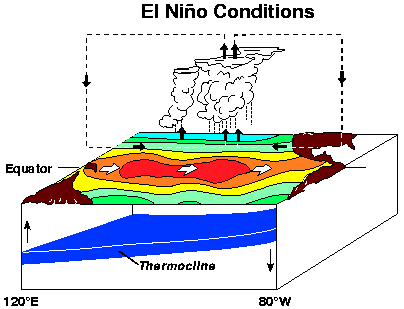
The warmer ocean waters are the result of relaxed trade winds (see 3D diagram above), which through various mechanisms, reduce the amount of cold water upwelling to the near-surface ocean along the Equator. In fact, El Niño was first recognized (and named!) by the fisherman along the northwest coast of South America. Here, the decreased oceanic upwelling, which typically supplies the surface water with abundant nutrients to support marine life (i.e. fish), had drastic negative impacts on fish output during El Niño years, typically near Christmas time. The name El Niño means “the little boy” in Spanish and is synonymous with Baby Jesus. On the contrary, fisherman tend to make out exceptionally well during La Niña years! The inter-annual pattern of shifts between El Niño and La Niña is known as ENSO, short for the El Niño Southern Oscillation. ENSO is the most influential determinant used in long-range forecasting around the world (1 month to 1 year time frame).
In the figure, notice how the atmospheric, thermally-driven circulation changes between normal and El Niño conditions. The upward motion of the atmosphere, and resulting convective storm development, follows the warm pool of ocean water. These are just the localized effects of El Niño . The atmosphere and ocean are intimately coupled on a global scale. This leads to locations all around the world, including Colorado, being influenced by ENSO.
The Forecast
To keep tabs on ENSO, researchers have deployed large arrays of buoys throughout the Pacific to monitor ocean temperatures at the surface and deep below. The most widely accepted/correlated temperature measurements come out of a region known as Niño 3.4 (shown below). From these measurements, the Oceanic Niño Index (ONI) is used to determine the current state of ENSO, with an ONI > 0.45 (warm anomaly) indicating an El Niño , an ONI < -0.45 (cold anomaly) categorized as La Niña, and the ONI in between coined as ENSO Neutral.
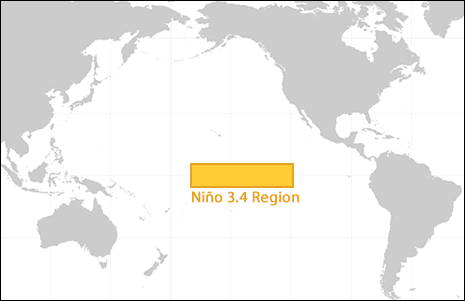
The 3.4 Niño region in the Pacific Ocean. This area is heavily monitored by scientists in order to keep tabs on ENSO.
The table below shows the ONI index for each month in the last five years.
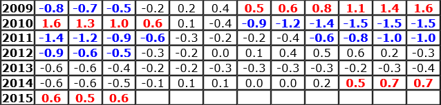
The Winter 2014-2015 season just barely hurdled the threshold into El Niño territory, despite the forecasts calling for a moderate one to develop. The current index is +0.6, a very weak El Niño . However, long-range models generally forecast an intensification through the summer into fall (see below).
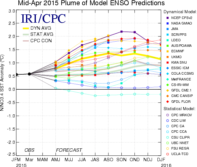
Plume diagram of model projections for the ONI index, showing the confidence that our current El Niño will continue into 2016.
The dynamical models (based on actual math) are trending towards a moderate to strong El Niño , while the statistical models (strictly based on past years’ data) are predominantly indicating a weak El Niño or even mildly neutral conditions. All models (except one), keep the ONI index positive through the end of 2015.
Our Impact
ENSO has been extensively studied in regards to weather around the world; you could even argue that it is over-examined. There is a lot of information floating around out there, some of which can be misleading. For example, if you are a skier in Colorado, you probably have heard that El Niño years deliver the most powder. This fallacy, like many others, are only half true.
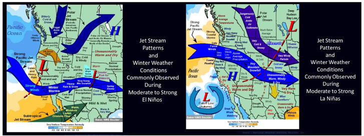
Assuming El Nino sticks around for a bit and even intensifies, the impacts on Colorado are not as significant as other locales around the country. Shown below are extremely simplified graphics that outline the major changes to our weather during El Niño (left) and La Niña (right) winters. Notice the slight southward shift in the jet stream during El Niño. This brings the storm track slightly further south, setting the stage for more blizzards across the Front Range and increased snowfall in general in the mountains of Southwest Colorado. During La Niña, the storm track is to the north, bringing frequent downslope wind storms to our region, more snow to the Northwest Colorado mountains, and more regularly occurring Arctic cold snaps to the Plains.
In general though, for Northeast Colorado, the facts surrounding El Niño are:
- Big snow storms are more frequent during El Niño in Boulder County, particularly in the Autumn and Spring seasons. Since 1950 in Boulder, 16 out of 28 (57%) snow storms dropping at least 15 inches in the city occurred during El Niño years, relative to neutral or La Nina years. Furthermore, 9 out of the 10 biggest snow storms on record came during El Niño years.
- However, there is no correlation between ENSO and total seasonal snowfall in the Front Range mountains or Plains. The more frequent big snows are often surrounded by relatively drier periods during El Niño. Boulder did see 138″ of snow during the 2009-10 El Niño event (the most recent one), the second snowiest season on record in Boulder. This was mostly the result of a few large snow storms.
- There is also no significant correlation between El Niño and temperature for Boulder County, but there is less overall wintertime cold outbreaks and wind storms for the Foothills and Plains.
- A El Niño can slightly enhance the monsoon, but not so much for Northeast Colorado
Now that you have the facts about El Niño in Colorado, spread the correct knowledge. Keep in mind that even the mentioned correlations are quite low for our region. The “randomness” of Earth’s complicated weather from year-to-year is still King.
Stay tuned to BoulderCAST for future updates on the developing El Niño through the year. Follow us Twitter for frequent weather updates and subscribe to the site to get these posts delivered to your email box (enter your email in the sidebar widget to right)!


You must be logged in to post a comment.