We’ve been tracking the storm very closely over the last week. With forecast temperatures trending down over the last several days, the threat of potentially flooding rain has morphed into the concern for a dumping of heavy, wet spring snow for everyone across the Front Range. Read on as we present our final forecast for this historic storm.
What seemed near impossible just a few days ago has come to fruition. While we knew the Foothills would be in store for a wallop of snow this weekend, sizable accumulation was much less likely on the Plains. We have some lingering concerns, but in general, are fairly confident in that which will transpire through the weekend, mainly…heavy wet snow for all!
All of the ingredients are coming together, and will remain together, into Sunday….
✔ TRACK
The 500 mb low will be moving right into position over northwest New Mexico later this evening. This will put Colorado in a prime position for synoptic lift.
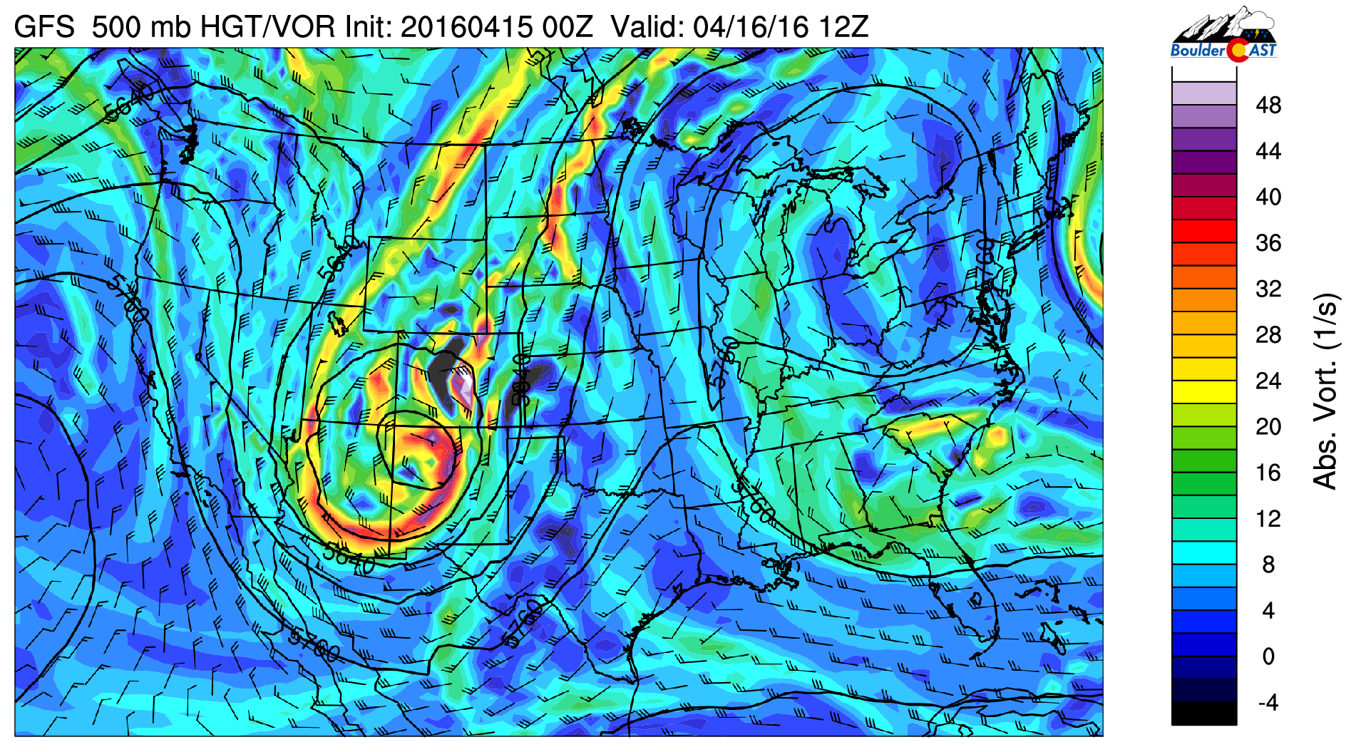
GFS 500 mb vorticity map, valid Saturday morning, showing the upper-low over NW New Mexico
It will wobble and move very slowly northward into western Colorado by Sunday afternoon.
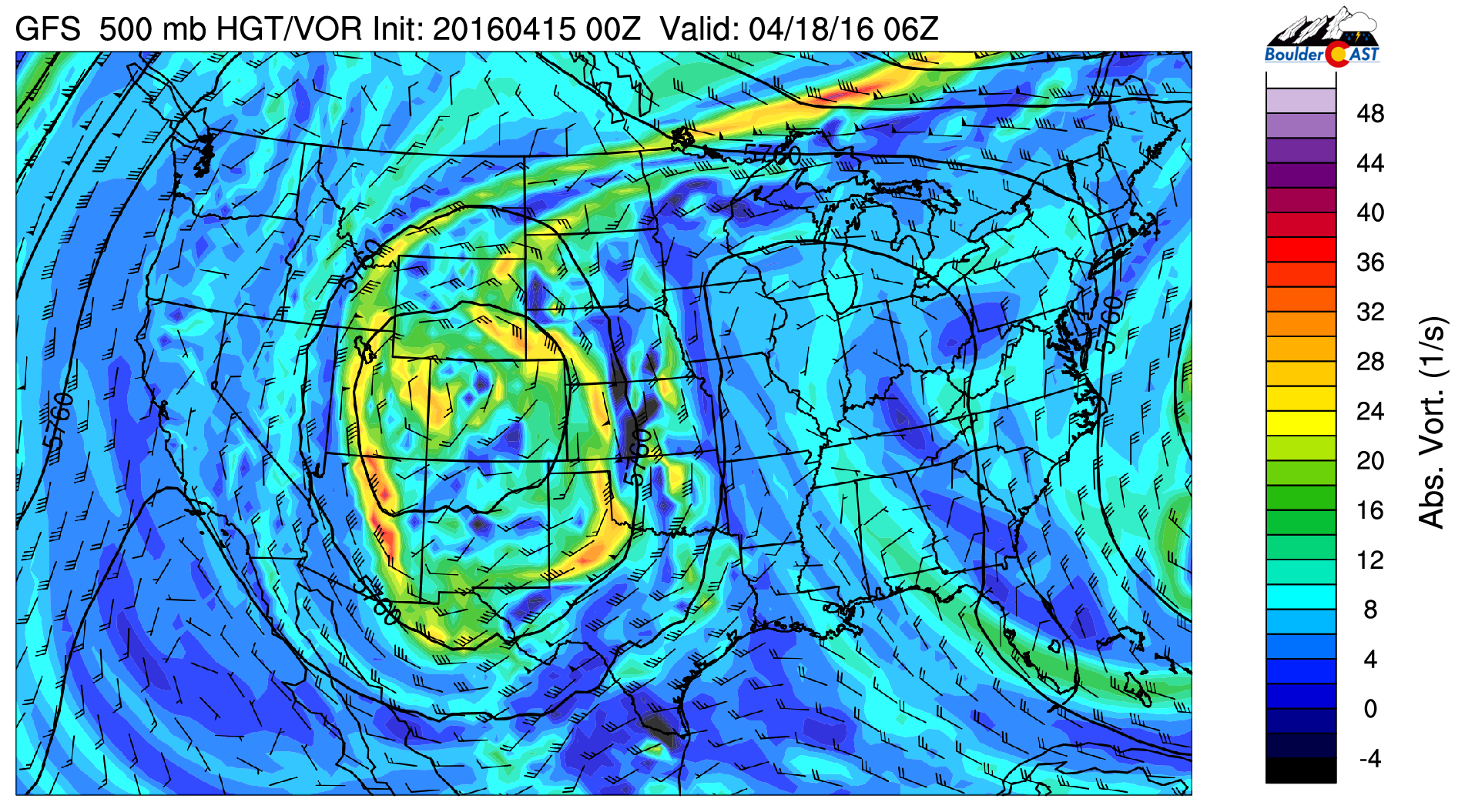
GFS 500 mb vorticity map, valid Sunday night, showing the upper-low over western Colorado
Upslope will be present (in some form) from Friday afternoon through mid-day Sunday. It will be deep and strong during the height of the event Friday night through Saturday night. At times, it will extend up to 550 mb (about 13,000 feet above ground) and reach 50 mph from the northeast in the middle atmosphere! The large, “omega” high across the eastern USA is the reason for our stalling storm system.
✔ MOISTURE:
The southerly flow on the east side of the low will pump deep Gulf of Mexico moisture straight into Colorado for the duration of the weekend.
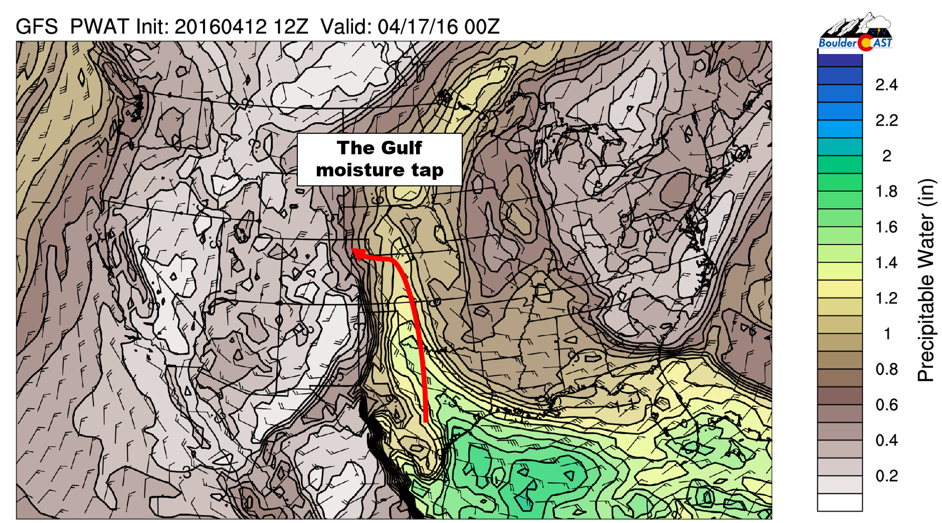
GFS forecast precipitable water content for Saturday. Notice the SE flow with high levels of moisture tracing back to the Gulf of Mexico
Moisture won’t be as high in Denver as in far eastern Colorado, but it should be sufficient to support big fluffy flakes and high snowfall rates.
✔ COLD AIR:
Cold air has been the biggest factor contributing to increased snow totals across the Plains for this storm. What looked like a rain event early in the week, slowly but surely transitioned into a snow event as colder air was projected for the Front Range. A push of colder air will move in later this evening from the north and west. This will lower snow levels all the way down to the Plains around midnight tonight.
During the day Saturday, air temperatures will be 31-35 degrees across the Plains, but with the intensity of the snowfall, significant accumulation will still occur. Later Saturday evening, a secondary push of cold air comes in, which could drop temperatures into the upper 20’s across the Plains. It’s unclear how much snow will still be falling at that point, though.
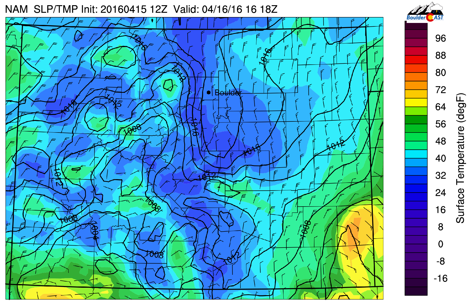
NAM surface temperature and wind forecast for mid-day Saturday. Notice the cold air across the Denver air, in the low to mid 30’s
✔ TIMELINE:
Scattered light rain will develop through the afternoon on Friday. Snow levels will be high initially, near 8,500 feet, but will be dropping through the evening, reaching down to near 5,500 feet by midnight. Snow levels will continue to fall overnight, bottoming out on the Plains from east to west just after midnight, at which point everyone should be changed over to a heavy, wet snow. By sunrise tomorrow, the higher elevations could already be approaching a foot, with several inches of wet accumulation possible on the Plains.
Snow will continue through the day Saturday, heavy at times. Rates nearing 2″ per hour will be possible in the heavier bands and in the Foothills. The heaviest snow will likely occur between 6am and 6pm Saturday, with significant daytime accumulation possible.
Snow will lighten up in intensity and coverage later Saturday night, but persist into Sunday for the areas in and near the Foothills. Light snow may periodically fall in highest elevations through Tuesday.
✔ LINGERING CONCERNS:
With the long duration of this event, the tail end of the storm is masked in a bit of uncertainty right now, mostly due to the storm’s northward movement speed over the weekend. How long snow lasts into Saturday night will impact final snow totals (obviously). More recent model trends want to move the system northward quicker and elongate the upper-low northward. This brings a dry slot into the region before midnight Saturday night, something that didn’t happen until the morning hours Sunday in prior runs. This change could end up bringing snow totals down a bit.
We’re also not seeing 100% ideal upslope conditions across the region. The low-level winds in particular have an almost straight northerly component (parallel to the mountains) during the day Saturday (see below). This isn’t a deal-breaker, as there are plenty of other ingredients in place to aid in heavy snowfall, including more favorable upslope in the middle layers of the atmosphere, around 700 mb.
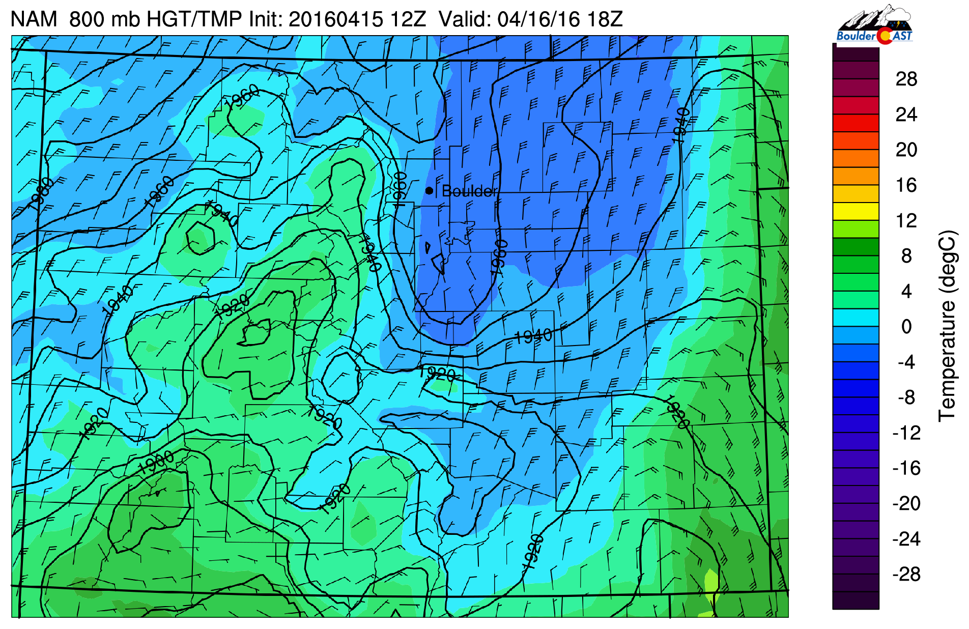
NAM 800 mb temperature and wind forecast for Saturday afternoon. Notice the less-than-ideal northerly wind direction across the Plains
These are just two aspects of the event that could be more favorable, which in the end, may negatively impact snow amounts.
✔ EXPECTED SNOW AMOUNTS:
We’ll preface by reminding everyone that we are in mid-April. The sun is very strong and the ground is warm (it was 78 degrees in Boulder yesterday). The initial chunk of snow Friday night/early Saturday will have significant melting due to the warm ground. Then, during the day Saturday, the sun will be working on the snow that is falling.
With air temperatures from 31-35 degrees for the bulk of the long-duration event (on the Plains), the snow will be very soupy and compacted. So it’s hard to say how deep the accumulating slushy snow on the ground may be at any given time. Just be aware that it will be less, probably much less, that our forecast amounts, especially on the Plains.
With that said, the models are indicating 1.5-3.5″ of liquid for the region, with the highest amounts in the Foothills.
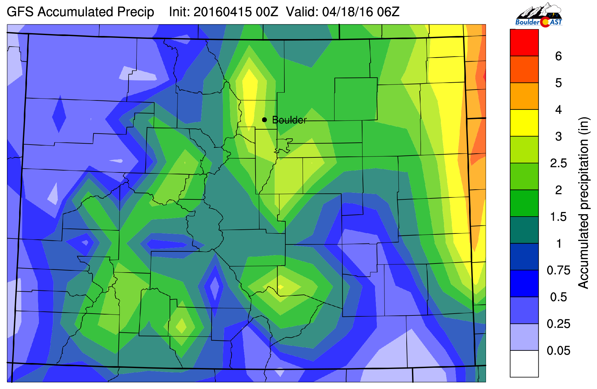
GFS total accumulated precipitation through Sunday night. 1.5-3″ of liquid are progged for the Front Range
Assuming the onset will be rain, then changing to snow with a soupy 7:1 snow-to-liquid ratio on the Plains, this equates to about 8-16″ of accumulation. In the higher elevations, it will be mostly an all snow event with a 10 to 12:1 ratio. 2 to 3 feet will be likely, with locally higher totals definitely possible.
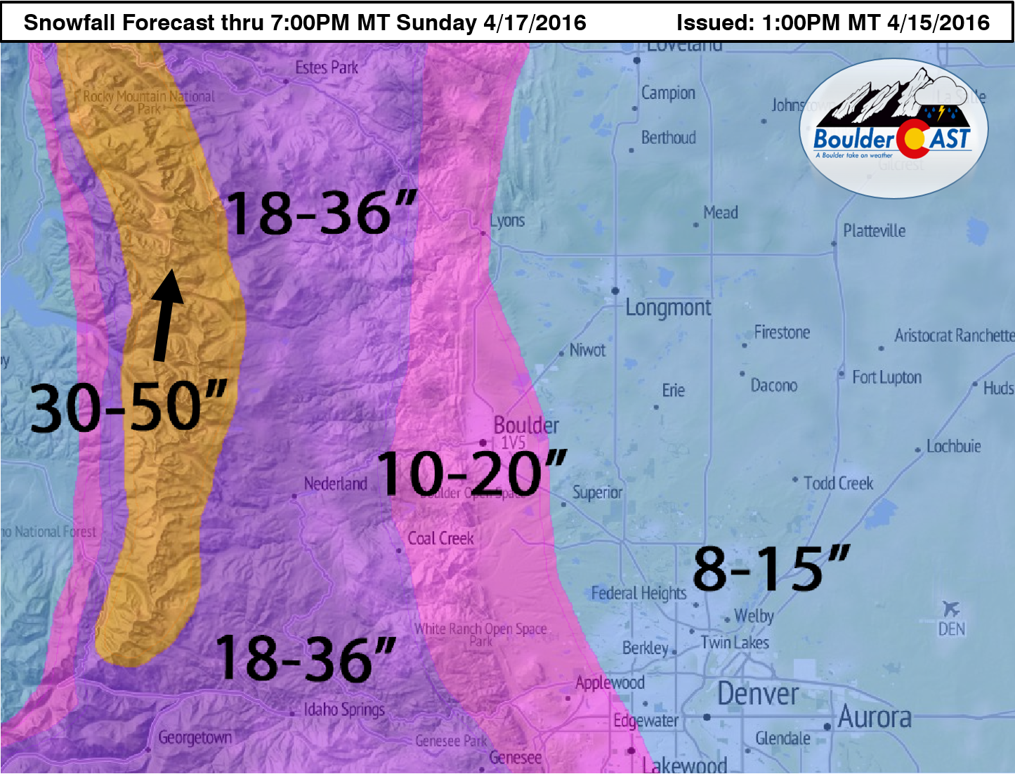
Our snowfall forecast map is shown below. Yes that’s 30-50″ over the Divide!
✔ ANTICIPATED IMPACTS:
Roads: This is a tough call. With the heaviest snow falling during the day Saturday, the April sun will battle accumulation on asphalt with great honor. We expect roads will become very slushy and possibly snow-covered across the Plains intermittently through the day Saturday on the Plains. In the higher elevations, dangerous travel is almost a given with snow measured in feet.
Downed trees / Power outages: With foliage quite abundant across the Plains, the heavy wet snow falling this weekend will definitely bring the concern for widespread power outages Saturday. If you want to save you blooming cherry tree’s branches, it would behoove you to shake the snow off several times if possible this weekend.
DIA: The snow will be lighter out towards DIA. It will also be warmer there as well compared to Boulder. Delays in some capacity are likely given the magnitude of this storm. If the runway can remain snow-free, the biggest concern will be visibility in the heavier snow bands. Overall, not a great day for air (or car) travel. If you have to, good luck!
————————
This is shaping up to possibly be the storm of the decade! Stay tuned later this evening as the BoulderCAST Live Blog will activate for the storm. We’ll pass along any updates over the weekend if needed. Stay safe everyone! Think warm thoughts; a return to those 70’s is closer than you think!


You must be logged in to post a comment.