Cooler weather and beneficial rains are spreading across the Front Range as monsoon moisture collides with a cold front on our doorstep. Continue reading for rainfall amounts, timing, and when to expect that brutal August heat to return.
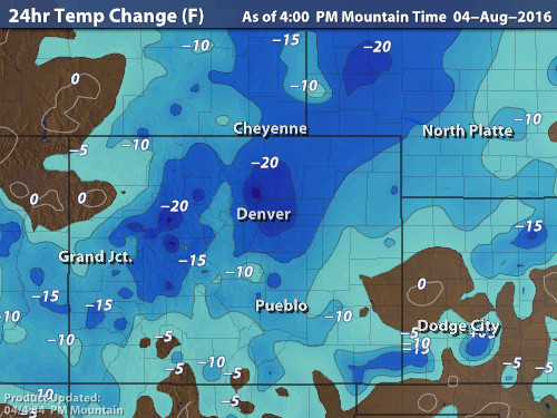
We alluded to today’s cool-down and gloomy weather earlier in the week. A cold front surged into the state overnight last night. 24-hour temperature changes are quite impressive across much of northern Colorado (by summer standards). As of 4PM at BoulderCAST Station, today’s temperature is 27 degrees colder than yesterday (68 degrees today, 95 yesterday).
Looking ahead to tomorrow, temperatures in our region will be the coldest in the entire country (see below)…likely unable to climb out of the 60’s. This is around 20 degrees below normal. Many areas could set record-low maximum temperatures. Boulder needs to stay 68 degrees or cooler to do so.
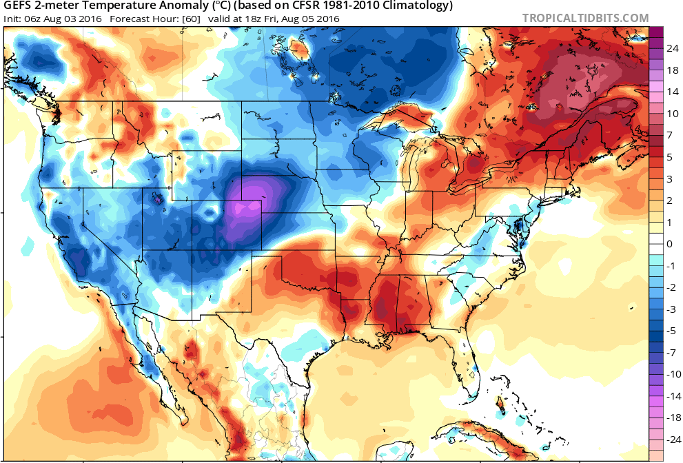
GFS ensemble forecast temperature anomaly for Friday afternoon. Temperatures in northeast Colorado will be 15-25 degrees below normal for early August
Light rain will continue on and off through Thursday night and into early Friday. This is all associated with a small, but impactful upper-level disturbance moving across the state. The dip associated with the upper-low can be seen in the 500 mb height and vorticity map below, valid this evening.
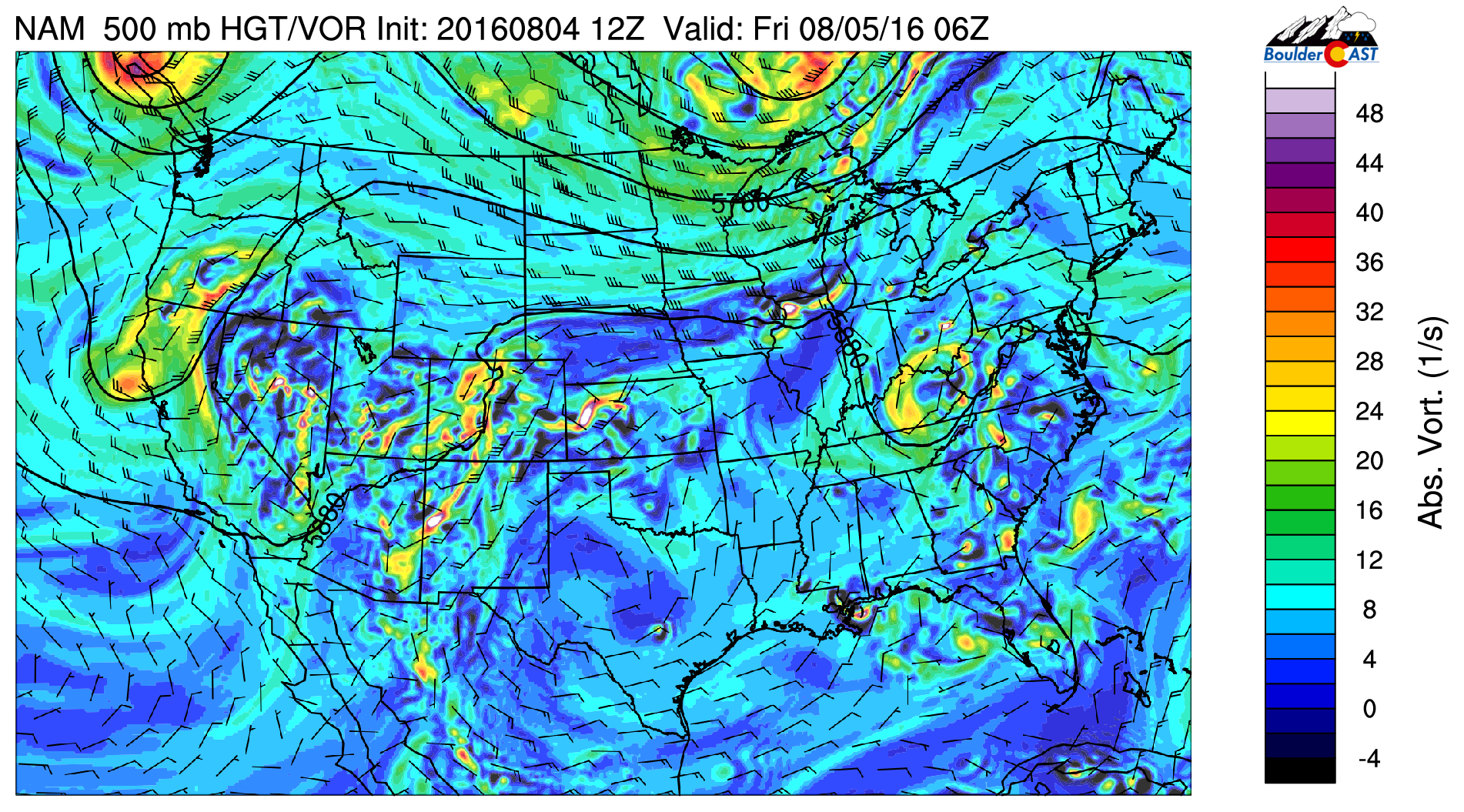
GFS 500 mb vorticity map for Thursday night showing an upper-level disturbance moving across Colorado
You can also notice above the rather intense southerly flow beaming into Colorado from western Mexico (30 to 40 knots). This monsoonal flow is helping to transport copious amounts of moisture northward into our region. The total atmospheric moisture anomaly for Friday is shown below. Very moist across our state!
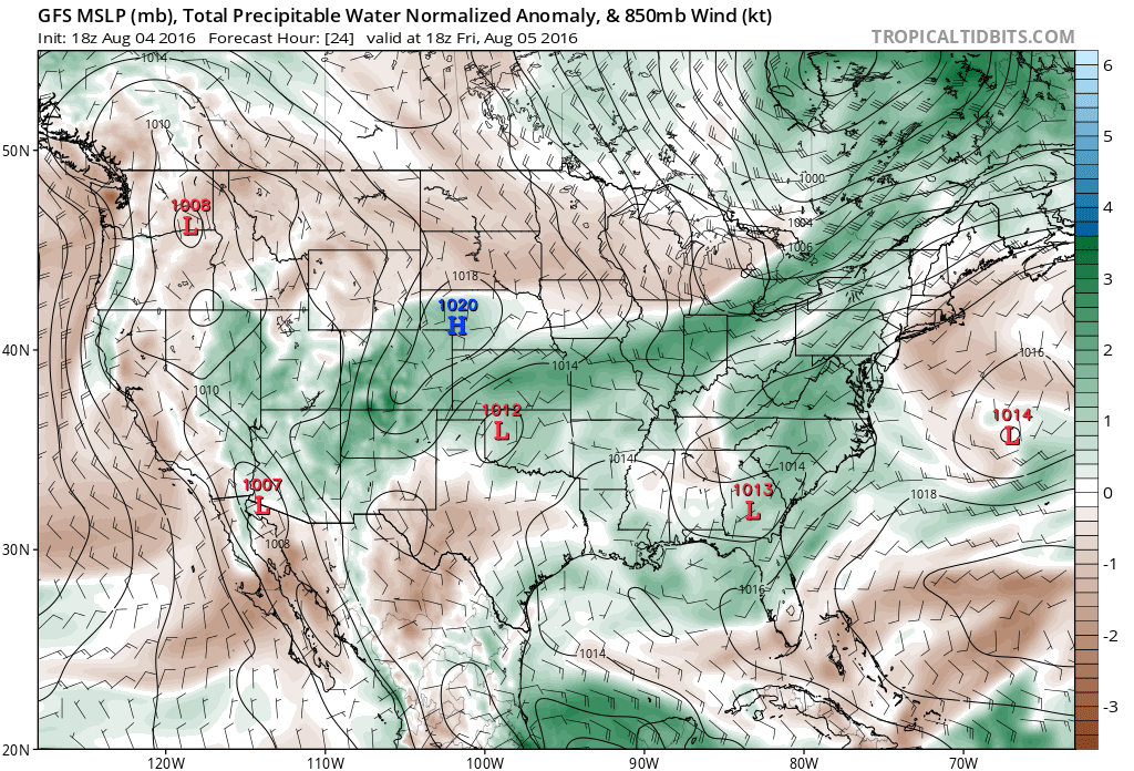
GFS moisture anomaly and mean wind for Friday afternoon showing the plume over monsoon moisture across Colorado
It’s also worth mentioning that the highest of the high elevations will see some snow mix-in late tonight and early Friday, and possibly again late Friday night. The atmospheric forecast sounding for 6AM Friday over the Interstate 70 corridor is shown below. Note the red line (temperature) crossing the 0-degree (freezing line) at around 550 mb. This is roughly the altitude of our 14ers. Snow will likely mix in and possibly accumulate a slushy coating down a little lower, say to 13,500 feet. Not likely a major impact for anyone, but nonetheless, August snow is always fun!
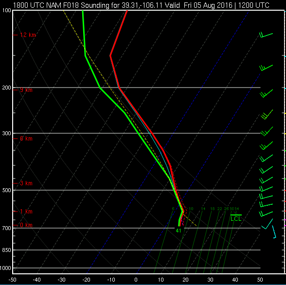
Forecast atmospheric sounding for the Mountains at 6am Friday, showing a very wet atmosphere and the potential for some snow across our highest peaks.
After a brief lull in the action Friday late morning and early afternoon (but still overcast skies), showers and a few storms will redevelop Friday early evening. Alongside the high moisture content of the atmosphere, there will be a threat of flooding. The best chances for that will be across the higher elevations. As such, parts of the state are under a Flash Flood Watch, including the areas in Boulder County above 10,000 feet.
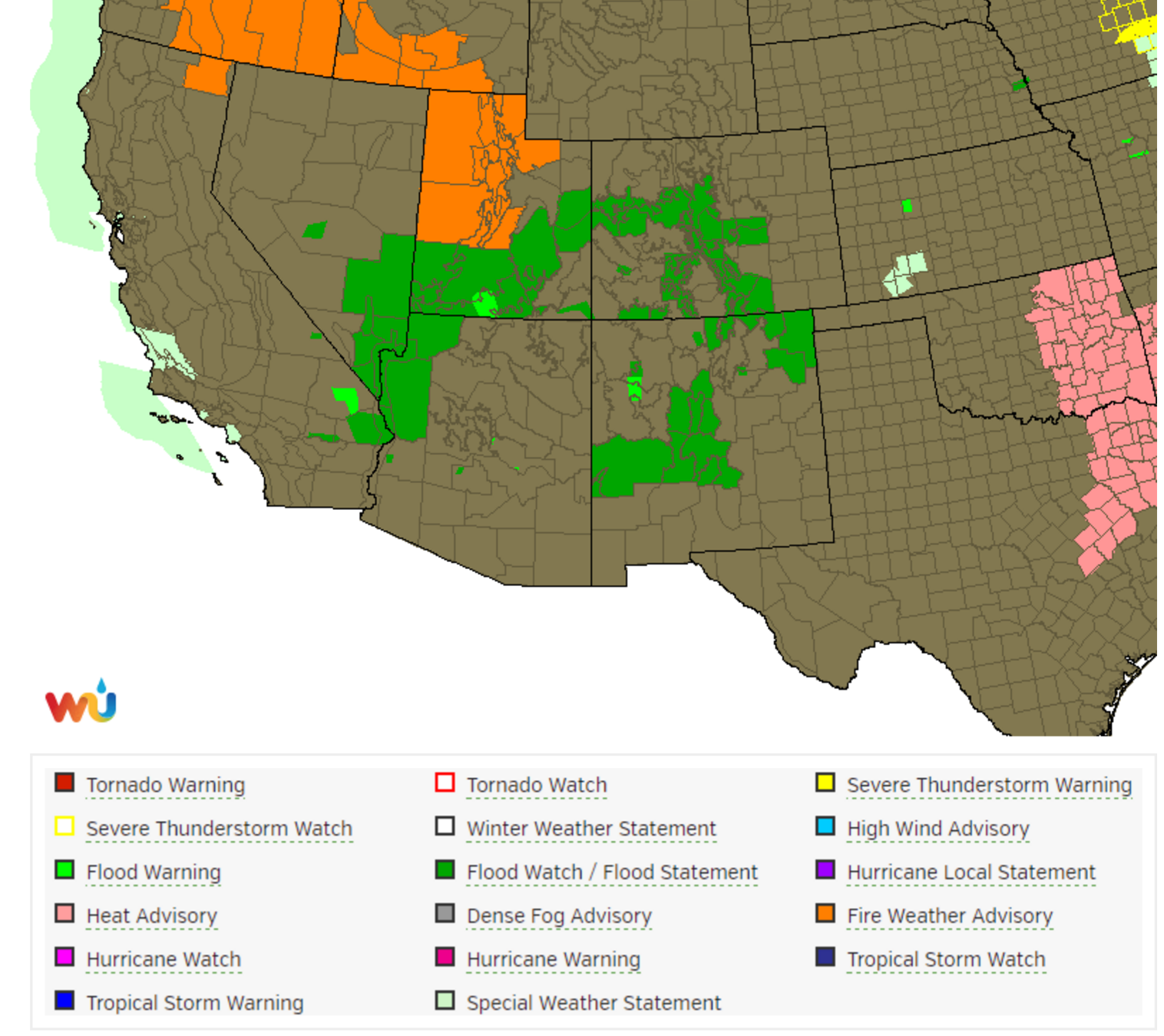
Current weather highlights across the southwest USA, including Flood Watches across portions of the region
The model forecast precipitation for the state through Sunday morning is shown below. Denver and Boulder will both be on the northern edge of the heaviest precipitation. We’ll need to watch areas south of Interstate 70 for heavy flooding rain. A general 1-3″ of rain can be expected there in the next two days. In the Metro Area, were looking at 0.5 to 1.5″ of rain. Not as extreme, but still significant, especially when considering Boulder has recorded less than one inch of rain across the last eight weeks combined.
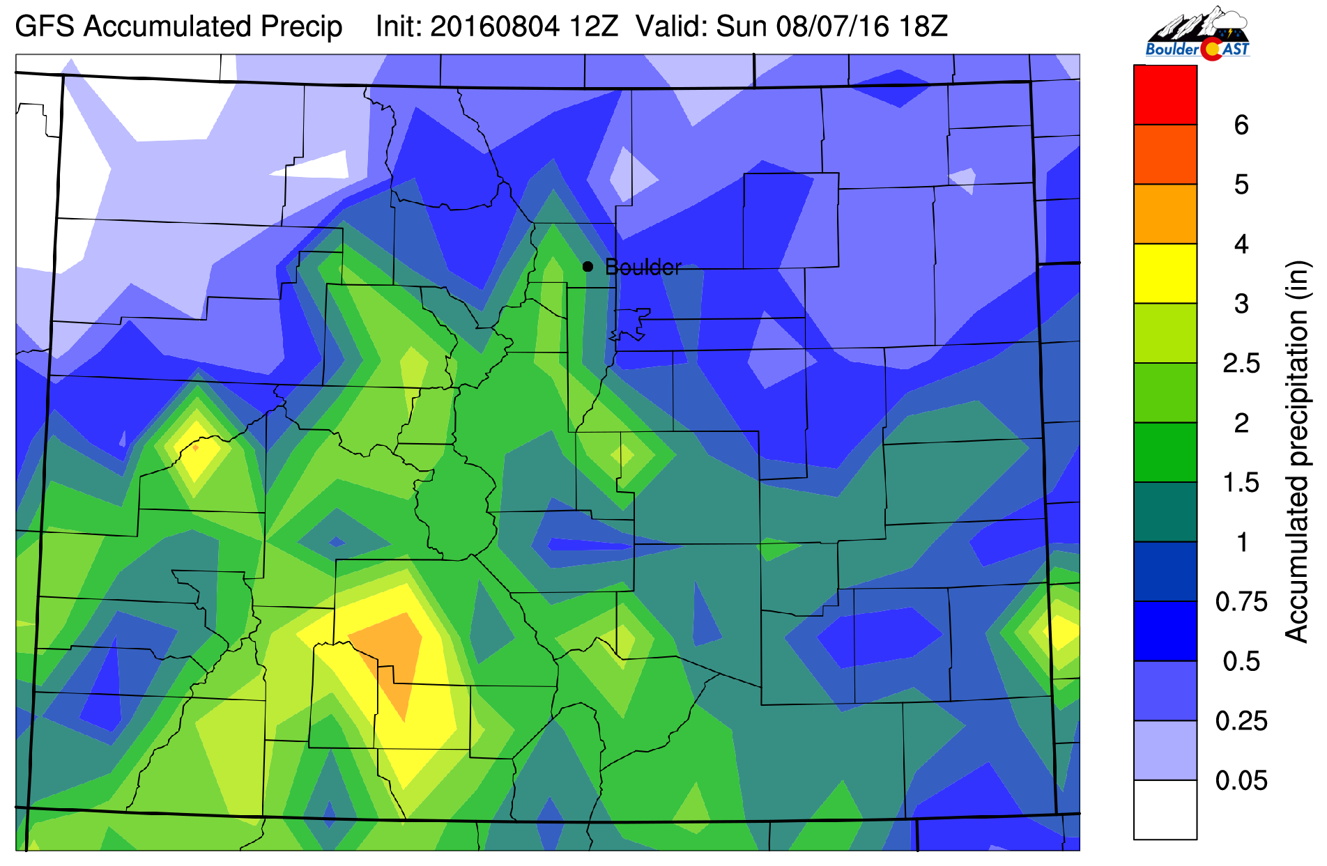
GFS forecast total precipitation for the region through Sunday morning. Heavy rain, especially across southern Colorado, is likely.
The cool and gloomy weather won’t stick around long. By Monday, we will dry out significantly and begin to heat back up to near 90 degrees. If your looking to accomplish some outdoor activities this weekend, start early. Both Saturday and Sunday will see afternoon and evening storms (more so Saturday), especially higher up. Enjoy these few “Pacific Northwest” days. We all know they are few and far between…


You must be logged in to post a comment.