After several 60+ degree days, Saturday’s snow storm brought an end to the unseasonably warm and dry start to December across northeast Colorado. We briefly recap the storm totals and discuss the good and bad of our forecast.
A light snow event was projected, with the possibility of a few locally heavier snow bands associated with a nearby upper-level jet streak. We issued our forecast on Friday afternoon, calling for a general 1-3″ of snow across the Plains of Boulder County, with 3-6″ in the Foothills. We expected Denver may see a little more snow with the low to the southeast, so we predicted 2-4″ there. The National Weather Service had a Winter Weather Advisory in effect for our Foothills, but no winter highlights were issued for the Plains. They painted a broad 2-6″ brush across all of the Denver Metro lower elevations.
Snow developed early Saturday morning, initially as a single, heavy snow band stretching from Breckenridge to Cheyenne (shown below). At its core, snowfall rates exceeded 1″ per hour. Boulder was in and out of this band for several hours.

Eventually, that band headed eastward, and the snow tapered off for us around 4pm. When it was all said and done, Boulder officially recorded 3.3″ of snow. At BoulderCAST, we measured 3.6″.
Shown below is our original forecast snow total map, with the observed storm totals per location contained in boxes. Green boxes indicate that the observed snowfall was within one inch of the given forecast range, while red was outside the scope of our forecast.
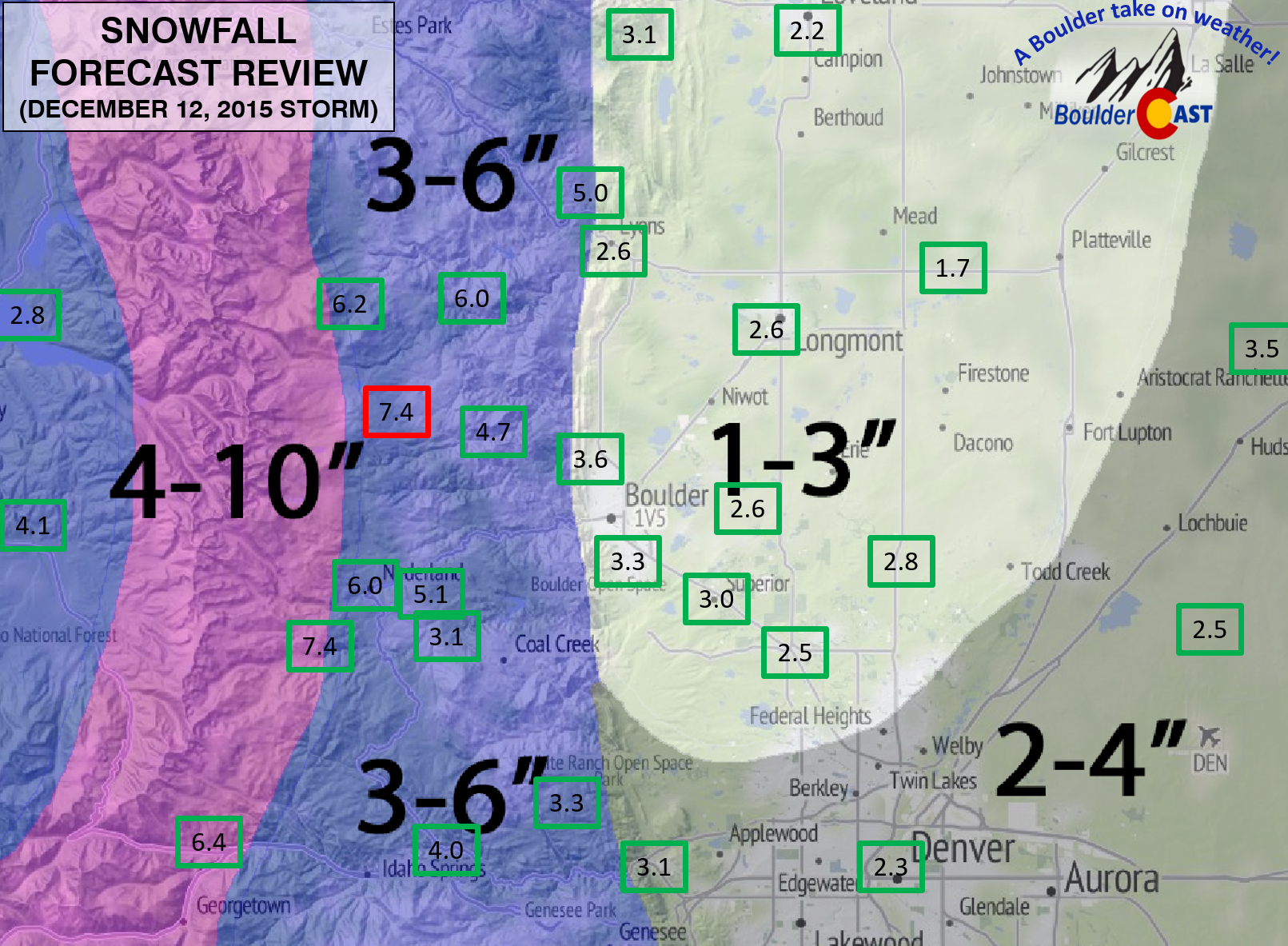
Overall, most places managed to push towards the upper bounds of our forecast ranges, thanks to these heavy bands, but almost every location was within one inch!
Not bad. We’ll call it a good forecast. Admittedly, the hardest decision was deciding whether to lower our forecast to 1-3″, or leave it at 2-4″ (as we were thinking on Wednesday). Both would have got the job done for this storm, however.
We have another similar storm on tap for Monday night. When it rains, it pours. Well, not exactly, as it’s too cold for rain, but you get the point. Check back for updates tomorrow.
Feature image credit: TheRockyGallery.com


You must be logged in to post a comment.