
With El Niño now approaching record levels, we crunch the numbers to see what type of impact we could potentially see in Boulder as the we head through the autumn season. Spoiler: we think it involves an epic snow storm!
ENSO Forecast Update
Last time we checked in on El Niño, it was moderate strength, but the forecast consensus was for further strengthening through summer and into the fall, potentially becoming the strongest one on record. So far, through late-September, this forecast has been accurate. Shown below is an animated map of the Pacific sea-surface temperature (SST) anomalies, from July 1 to September 16, 2015.
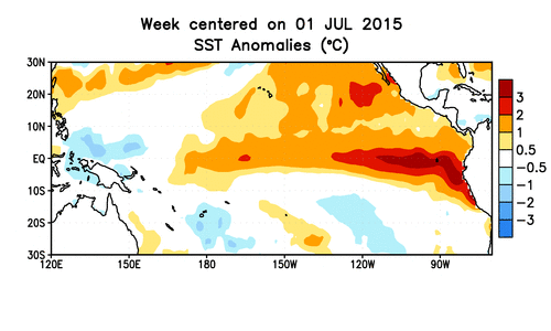
The greatest departures from normal are right along the South American coastline, extending west along the Equator, the signature of a conventional El Niño. However, there is also extensive warming that has propagated northward, just off the coast of the Baja Peninsula. The Oceanic Niño Index (ONI) is shown below for the last year.
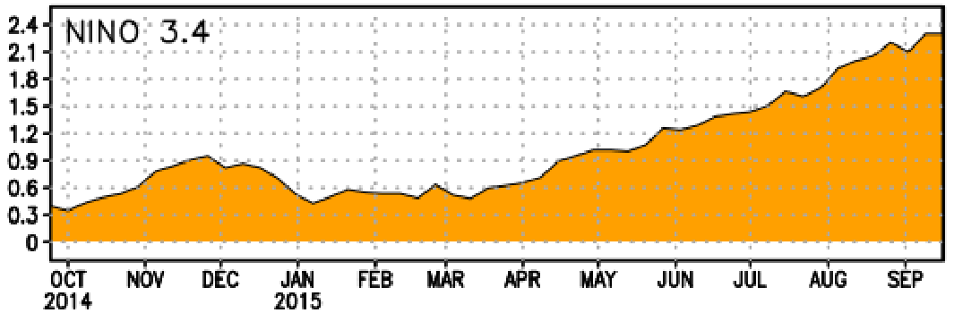
Notice the perpetual strengthening of El Niño, beginning in March, and the current ONI of +2.3 degrees Celsius. It is safe to say we are now in a strong El Niño. Looking forward, the climate model projections (shown below) concur on further strengthening, with the ensemble mean peaking at an ONI of +2.5 degrees Celsius in November.

If this forecast verifies, El Niño conditions will likely persist through May, with moderate to strong El Niño conditions lasting into March.
By the Numbers
With a strong El Niño on tap and expected to last through the fall season, what can Boulder expect in the way of precipitation, snowfall, and temperatures?
The figure below shows box-and-whisker plots of precipitation for Boulder for the monthly totals of October, November, and December. The black box-and-whiskers contain monthly rainfall totals for all years, stretching back to 1950. The orange plots show only the months for years where El Niños were occurring, while the red plots only represent months where moderate (or stronger) El Niños were present. The numbers at the top of the figure indicate how many years those particular conditions were present (data from official Boulder climate site at NOAA).
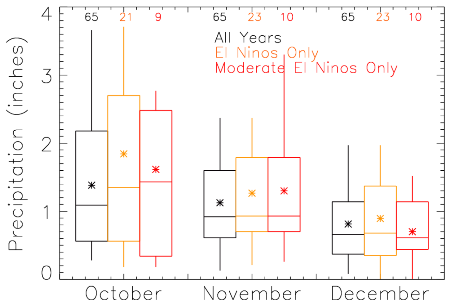
Notice that under El Niño conditions, both the mean and median precipitation in Boulder increases compared to average (orange vs. black) in October, on the order of 0.25-0.50″. (NOTE: Since the number of El Niño years are relatively small, the median is more representative than the mean for these data sets). Under moderate/strong El Niño conditions, the precipitation signal in October is further enhanced. However, November and December don’t shown any statistically significant difference from normal for precipitation during El Niño conditions.
El Niño is often mistakenly linked to tons of snow in Colorado. This is simply not true. In a recent post, we detailed two important facts regarding El Niño and snowfall for our region:
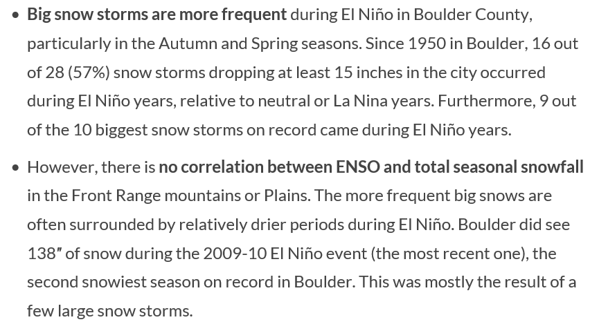
The take-away: El Niño doesn’t generally produce more snow, just bigger storms (especially in the transitional times, like Autumn and Spring), which are often surrounded by lengthy, dry periods.
Does the data support this claim? Shown below is an analogous plot to the one above, but now for snowfall.
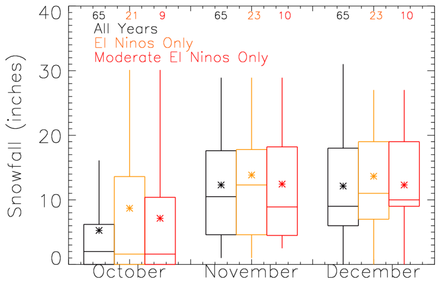
Wow, October should immediately jump out at you! Though the median snowfall actually decreases during El Niño events, the spread goes up substantially. This demonstrates that while October frequently sees very little snow during El Niño, massive, airport-closing snowstorms can occur, as was the case in 1997 and 2009, relatively frequently. November and December have less significant snow implications from El Niño. Focusing on red vs. black (since a strong El Niño is in place currently), the mean snowfall is nearly identical to normal years. However, there is a bit larger spread between the mean and median in November, again indicating less overall snow, but a better chance of a big snow month. For December, the spread is smaller for moderate El Niños, while the mean and median are within an inch or two of normal. December snowfall is apparently not influenced by El Niño, which is expected. The largest impacts in the Front Range occur in early autumn and spring.
Alright, one more set of these plots. Shown below is the same box-and-whisker plots, but now for monthly mean high and low temperatures.

There is not that much interesting here. Median high temperatures for all three months are lower during moderate El Niño events, but only by 1 to 2 degrees. Median low temperatures show no difference. This is expected, as temperature is not strongly correlated with El Niño in our region. However, typically there are less extended cold snaps during El Niño patterns.
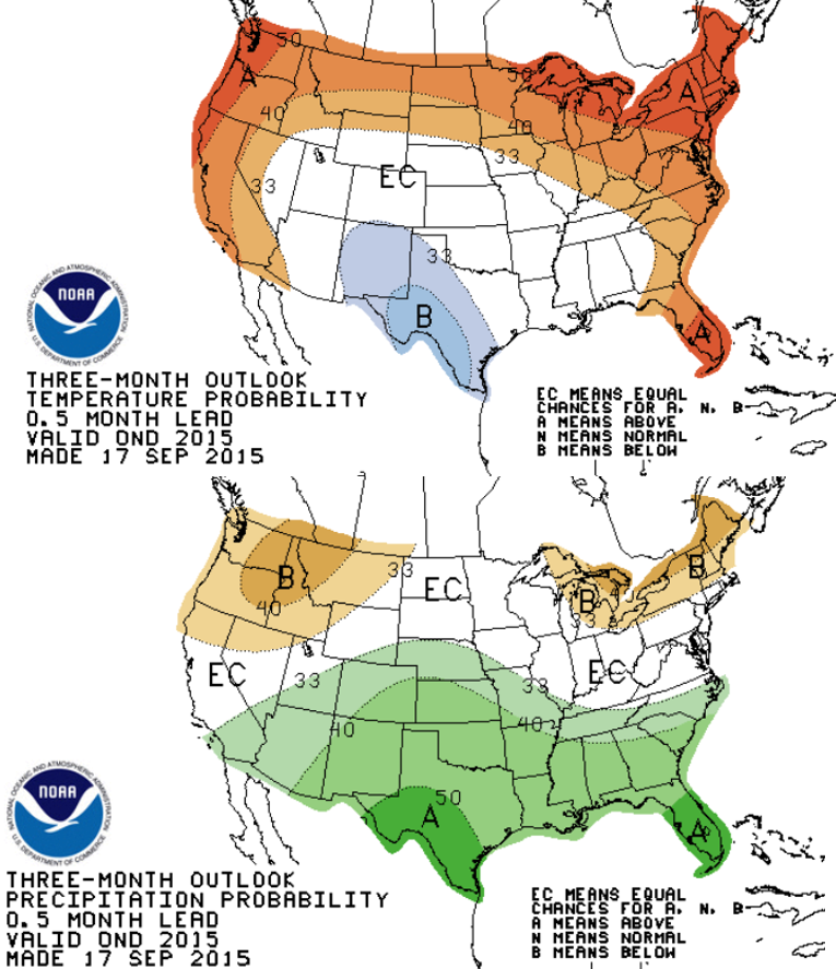
The NOAA Climate Prediction Center actually follows this theme, with their 3-month outlooks showing Colorado leaning towards “Equal Chance” for temperatures and >40% chance of wetter than average conditions for the October-December period.
In summary:
- A strong El Niño is here to stay through the end of the year (at least), currently sitting as the second strongest El Niño on record
- CPC makes no prediction for temperature in the fall, but El Niño statistics hint that temperatures could be a bit below normal
- October has the best odds to see a big snowstorm, but overall, less snow is generally observed during El Niño years in fall
- The CPC is forecasting elevated chances of a wet (i.e. snowy) autumn.
We have reviewed the statistics of past El Niño autumn seasons, and nothing more. Remember, as with most of meteorology, nothing is ever set in stone. Don’t expect anything as historic as the 1997 October blizzard, but also don’t be surprised if you wake up to a foot of snow!


You must be logged in to post a comment.