Not surprisingly, there is already A LOT of media hype surrounding the potential for another “epic snowstorm” this weekend across the Denver Metro area. It’s been all over social media and the news, with even a few shades of optimism present in our own forecasts. However, let’s take it one step at a time and not line ourselves up for disappointment. Continue reading as we set realistic expectations for this weekend’s potential storm.
The upcoming storm has behaved relatively consistently in the models for many days now. The action stems from a trough diving into the western United States out of the Gulf of Alaska at the end of the week. Right now it is still over the Aleutian Islands…
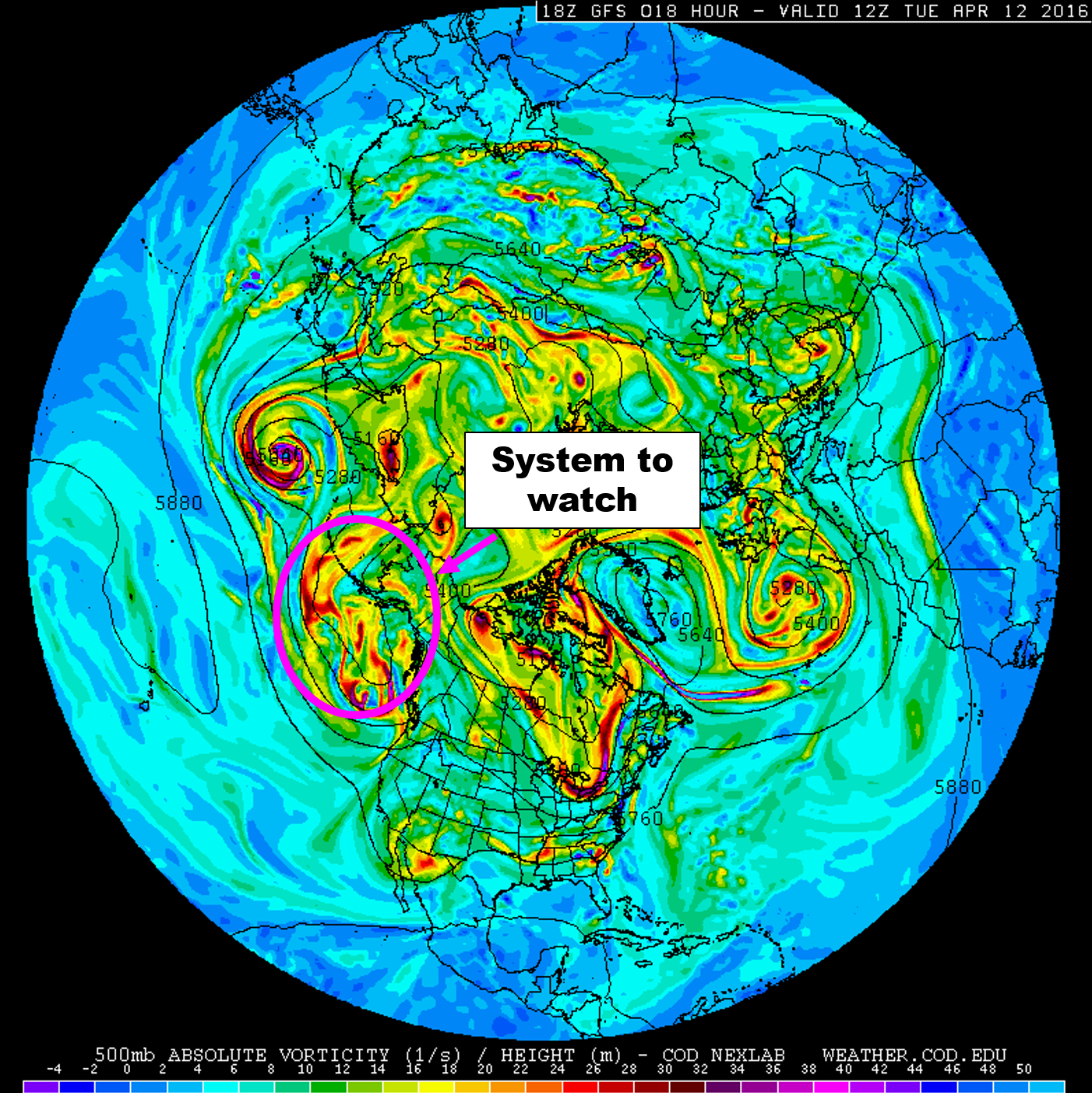
A look at the GFS 500 mb map for today from a polar perspective. The system were are tracking is located south and west of Alaska
The big change over the last day or two is the storm’s movement speed across Colorado, which as it appears currently, will be very, very slow. In the 500 mb forecast loop below, notice how the upper low (blue) tracks into the Four Corners region Friday night. It then cuts-off and remains stationary for several days.
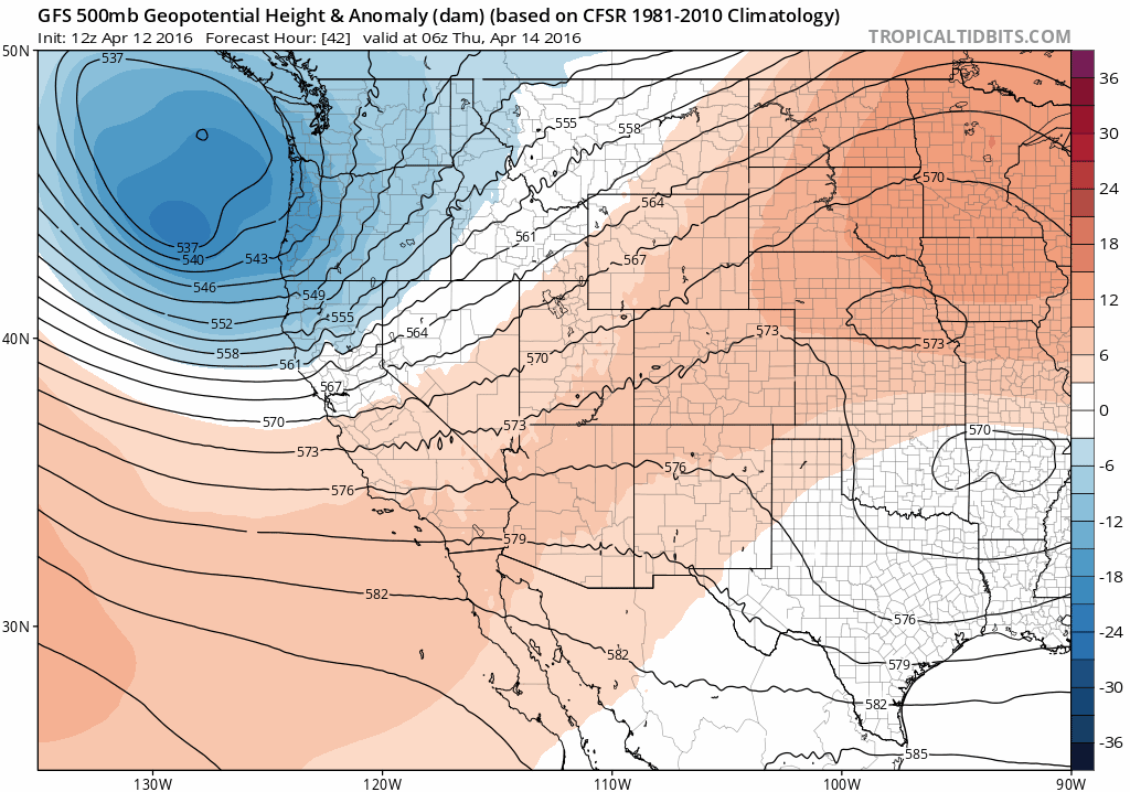
500 mb height and anomaly forecast for Thursday into Monday from the GFS. Pay particularly close attention to the track and how slow the low moves
Anytime a storm system this expansive and well-developed parks itself for a few days in one spot is a major concern, as it can produce precipitation that falls on the same areas for an extended period (see the 2013 Boulder Flood). This is especially true in the springtime when there is ample moisture and there can be enough cold air around to allow that heavy precipitation to fall as snow.
The system taps into relatively deep Gulf of Mexico moisture.
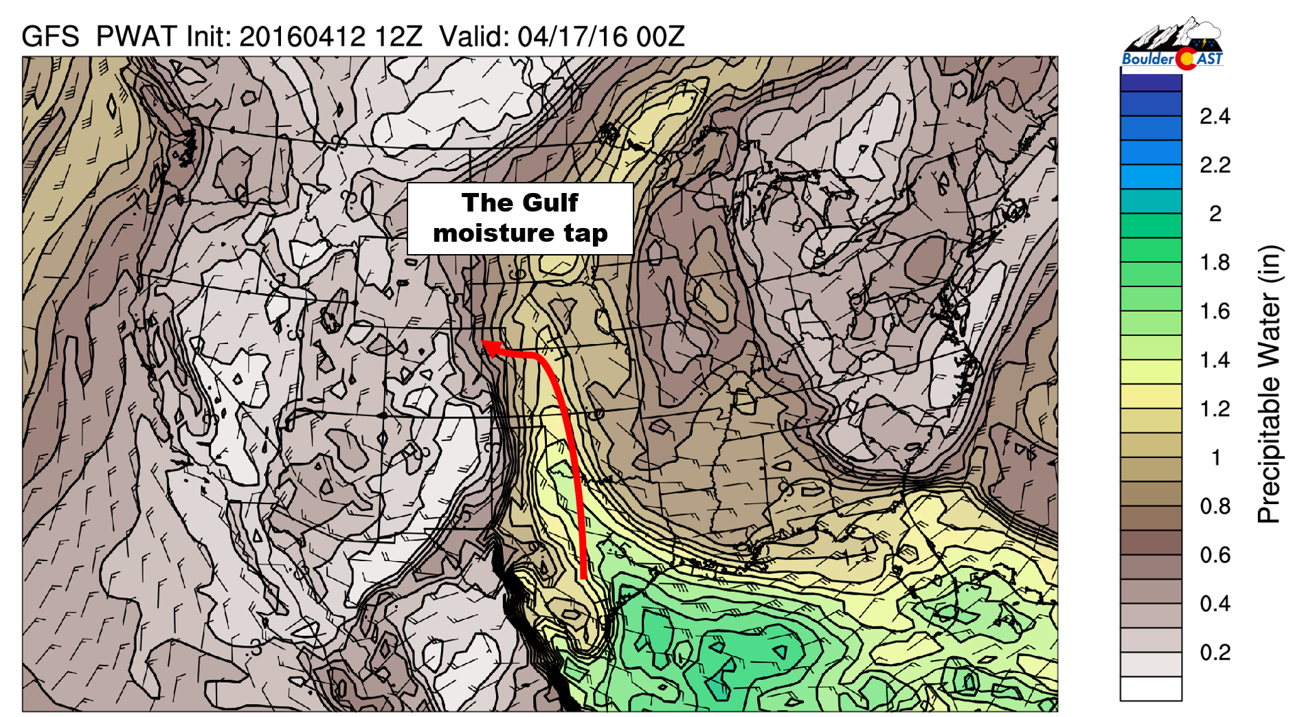
GFS forecast precipitable water content for Saturday. Notice the SE flow with high levels of moisture tracing back to the Gulf
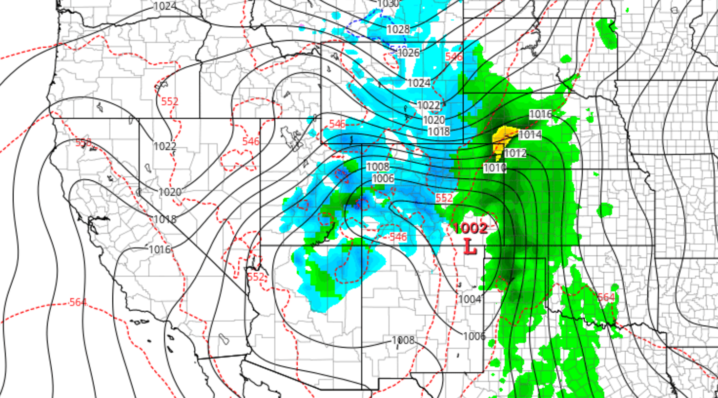
With the current track of the system heading for the Four Corners region, the Front Range could be right at the epicenter of the heaviest precipitation. Models indicate anywhere from 1.5 – 4″ of liquid is possible across the region through the weekend (highest totals in the higher elevations)…a result of the slow moving system’s upslope. All of the ingredients may come together just right, and persist.
All aboard the hype train!
The media hype stems from several European model runs yesterday which ran a little bit colder, bringing the appearance of heavy (and historic) snow to our entire region. Simply taking the model output at face value equated to 30 to 40″ of snow. And of course, you better believe the media let everyone in on that detail!
You all know better than to accept a single, erroneous model run five days in advance as hard fact. There are a lot of IF’s right now. Here are the big ones for us:
- First and foremost, will the track the models have been advertising (for the 500 mb low) across the Four Corners region and into southern Colorado verify? If it does, we have an excellent chance at picking up at least a period of moderate precipitation. If it doesn’t, this becomes someone else’s storm. We know how critical track is for Front Range weather due to upslope/downslope effects
- A key aspect of the event is the storm’s ridiculously slow movement speed. For this to happen, there needs to be a big impedance across the eastern United States to keep the low from trekking eastward. The GFS forecast for Saturday evening shows a huge, blocking high across the East Coast (see below). This the reason the models have been moving our storm so extraordinarily slow. We call this an omega pattern. Using your imagination, try to make out the Greek letter omega (Ω) from the outline of the ridge. We find it hard to believe the system will end up tracking as slow as the models are showing currently, but it’s at least plausible since the various models are agreeing relatively well. If it does move that slow, and if the track stays where it is, we’re in for big-time precipitation. If not, this system has the potential to be far from memorable for everyone.
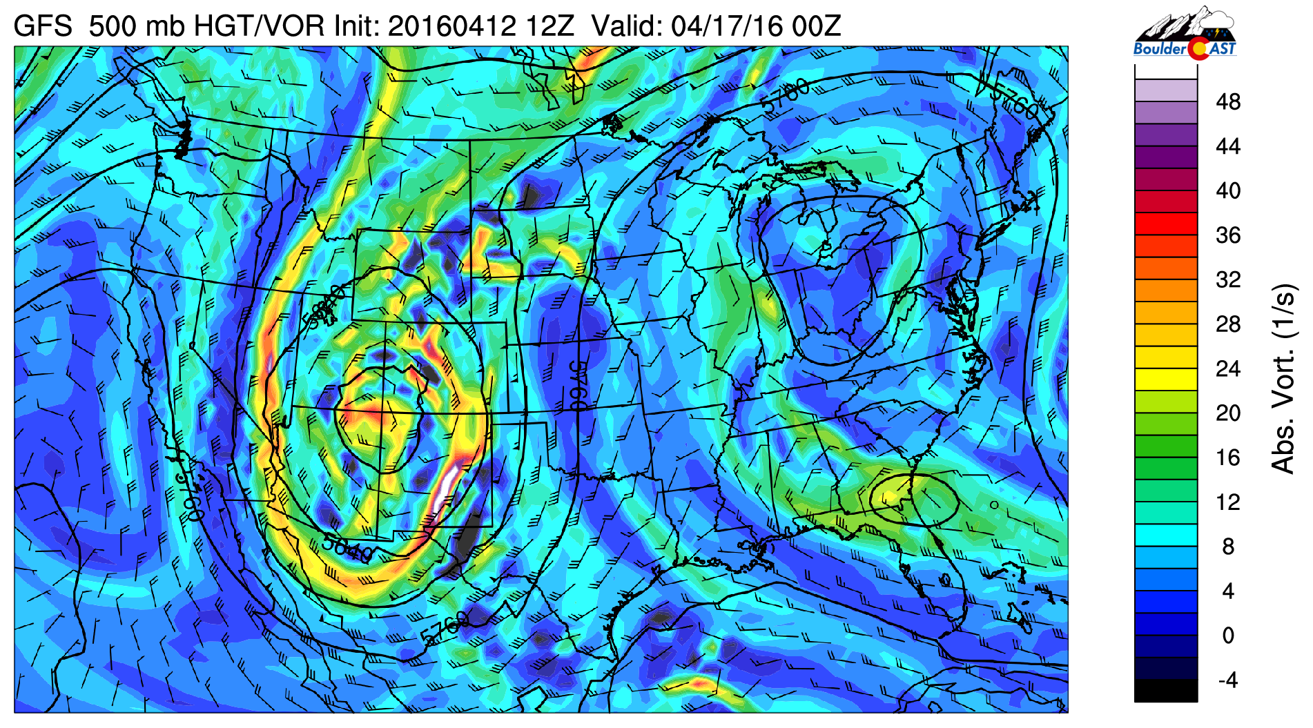
GFS 500 mb vorticity map for Saturday evening. The position of the low is right over the Four Corners, with a large ridge in the eastern USA
- As far as snowfall, we’re less than optimistic. The storm arrives past the mid-point of April. Getting snowfall, let alone prolonged snowfall, on the Plains is difficult (but by no means impossible!) this time of year. We’re just not seeing enough evidence that the lower elevations will be cold enough for significant snowfall to occur. There is cold air, but it’s just a matter of timing. It all depends on how the system evolves, more precisely, whether enough cold air can wedge itself down from the north into Denver during the height of the storm. ~90% of model solutions right now don’t have snow down low. We’re not saying it won’t happen, but it’s not looking good right now. The Foothills on the other hand, especially above 7,000 feet, will get absolutely slammed with snow if things remain in place as they are today.With the extended duration of the storm, we could foresee a scenario where snow levels rise and fall alongside the sun, bringing the threat of snow on the Plains Saturday and Sunday night, with rain during the daytime hours.
As an slight glimmer of hope, the latest two runs of the GFS model have been markedly colder, producing snow on the Plains Saturday night and Sunday. The latest surface temperature forecast shows temps in the low 30’s Saturday night.
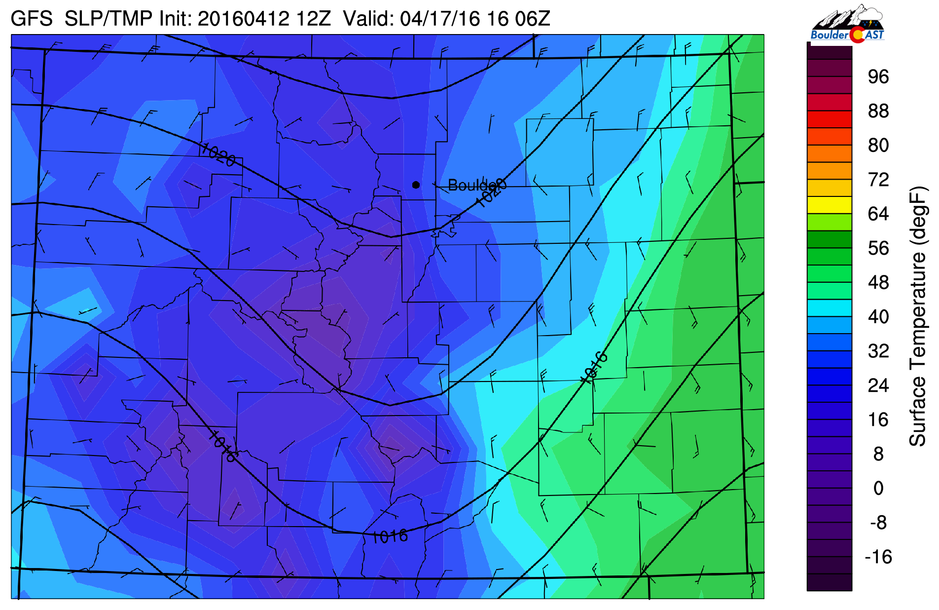
Latest GFS surface temperature forecast for Saturday night showing below freezing temperatures across Denver. Snow? This says yes.
Compare this to the GFS model run from Monday evening, where Metro area temperatures are in the upper 30’s.

An older GFS surface temperature forecast for Saturday night showing well above freezing temperatures across Denver. Snow? This says no
Those few degrees make all the difference, producing hefty snow amounts across all of the Front Range.
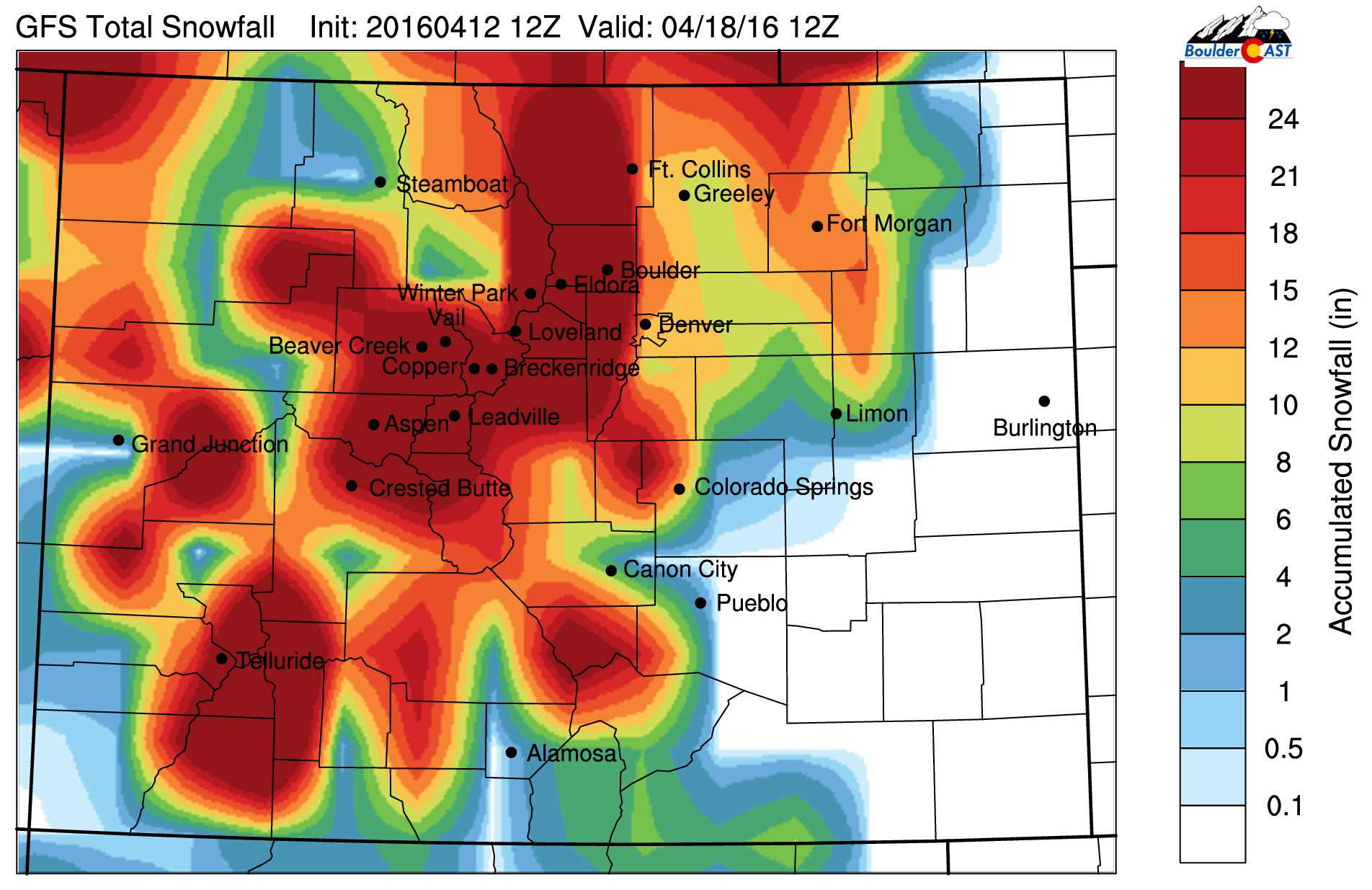
Latest GFS snowfall forecast through Monday morning. The colder temperatures produce big snows everywhere
Keep in mind the storm system is still a good four days out. The models just aren’t good enough to breed high enough confidence for us to make any type of forecast just yet, especially considering how many variables are at play. We’re leaning towards a mostly rain event for the Plains, with an elevated potential for heavy snow in the Foothills.
Summarizing what we know so far:
- A powerful storm system is set to move from the North Pacific into the Four Corners region by Saturday. Track and intensity have been more-or-less consistent for several days now in the models
- The storm has the potential to move very slowly, which could prolong precipitation for areas in the storm’s path
- Right now, it’s sights are set (mostly) on northeast Colorado, bringing the threat of prolonged precipitation to the region from Friday night through the weekend
- Currently, there isn’t enough evidence to proclaim that the lower elevations would see much snow out of this. A few model runs here and there are cold enough for significant snow, but they are definitely far outnumbered by rainy runs at this point. The Foothills have a fair chance to get rocked by snow, though.
- Finally, it is FOUR days away. Nothing is set in stone and things have a decent probability to end up differently than they are looking now
A solid forecast will definitely come into focus over the next few days. For now, plan on rain and thunderstorms developing Friday evening (some of which could be severe east of Denver), with precipitation chances remaining high through the day Saturday and into Sunday, with well below normal temperatures. Don’t rush for the bread and milk just yet. There is far too much uncertainty at this point!
Impress your friends by sharing the credible knowledge from this post, not unfounded claims for three feet of snow!
We’ll be on top of this the next few days with updates! Stay tuned, Colorado.


You must be logged in to post a comment.